
FCCInfo.com
A Service of Cavell, Mertz & Associates, Inc.
(855) FCC-INFO
|
|
|
|
|
||||||||||||||||
|
|
K224CN Channel: 224D 92.7 MHz Roseburg-green, Oregon Service: FX - A translator or application for a translator. Facility ID: 84109 Fac. Service: FX Programming Delivery Method: Unspecified Status: License Application Accepted: 07/21/1997 Application Granted: 03/13/1998 File Number: BLFT-19970721TI License Expires: 00/00/0000 Prefix Type: This is a license for a translator Application Type: License To Cover FCC Website Links: LMS Facility Details This Application CDBS Application Other K224CN Applications Other K224CN Applications in CDBS Including Superseded Applications Mailing Address Correspondence for K224CN Correspondence related to application BLFT-19970721TI Service Contour - Open Street Map or USGS Map (60 dBu) Service Contour - KML / Google Earth (60 dBu) Class: D, A Noncommercial educational operating with no more than 10W Site Location: 43-12-07.4 N 123-22-58.3 W (NAD 83) Site Location: 43-12-08.0 N 123-22-54.0 W (Converted to NAD 27) Effective Radiated Power: 0.082 kW Horiz. ; 0 kW Vert. Antenna Center HAAT: 172 m Horiz.; 0 m Vert. Antenna Center AMSL: 436 m Horiz.; 0 m Vert. Antenna Center HAG: 27 m Horiz.; 0 m Vert. Calculated Site Elevation: 409 m. (1342 ft.) Height Overall*: 31 m (102 ft.) (* As Filed In This Application, may differ from ASR Data, Below.) Directional Antenna Antenna Make/Model: None Antenna ID: 15084 Polarization:
| ||||||||||||||||||
| Antenna Data for Antenna Id: 15084 K224CN FX File: BLFT-19970721TI None - Service: FX | 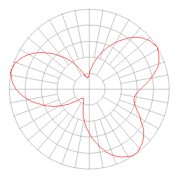 | ||||||||||||||||||
| Azimuth | Ratio | Azimuth | Ratio | Azimuth | Ratio | Azimuth | Ratio | ||||||||||||
| 0 | 0.176 | 10 | 0.323 | 20 | 0.495 | 30 | 0.671 | ||||||||||||
| 40 | 0.839 | 50 | 0.952 | 55 | 0.983 | 58 | 0.997 | ||||||||||||
| 60 | 0.988 | 70 | 0.924 | 80 | 0.787 | 90 | 0.644 | ||||||||||||
| 100 | 0.578 | 110 | 0.614 | 120 | 0.741 | 130 | 0.894 | ||||||||||||
| 140 | 0.977 | 145 | 0.997 | 150 | 0.974 | 160 | 0.885 | ||||||||||||
| 170 | 0.723 | 180 | 0.548 | 190 | 0.375 | 200 | 0.212 | ||||||||||||
| 205 | 0.157 | 210 | 0.138 | 215 | 0.144 | 220 | 0.159 | ||||||||||||
| 230 | 0.264 | 240 | 0.427 | 250 | 0.599 | 260 | 0.768 | ||||||||||||
| 270 | 0.913 | 280 | 0.987 | 283 | 1.000 | 285 | 0.991 | ||||||||||||
| 290 | 0.965 | 300 | 0.864 | 310 | 0.701 | 320 | 0.529 | ||||||||||||
| 330 | 0.361 | 340 | 0.209 | 345 | 0.165 | 350 | 0.145 | ||||||||||||
| 355 | 0.145 | ||||||||||||||||||
Structure Registration Number 1019017 [ASR Heights Differ from K224CN Application] Structure Type: TOWER Registered To: JATCOM COMMUNICATIONS INC Structure Address: Nebo Ridge 2.8 Km Sw Center Of Roseburg Or Roseburg Green, OR County Name: Douglas County ASR Issued: 02/23/2009 Date Built: 01/01/1991 Site Elevation: 406.9 m (1335 ft.) Structure Height: 30.5 m (100 ft.) Height Overall: 36 m (118 ft.) Overall Height AMSL: 442.9 m (1453 ft.) FAA Determination: 02/20/2009 FAA Study #: 2009-ANM-170-OE Paint & Light FAA Chapters: NONE PRIOR STUDY 1996-ANM-1007-OE 43-12-07.4 N 123-22-58.3 W (NAD 83) 43-12-08.0 N 123-22-54.0 W (Converted to NAD 27) |
1303 Jewel Drive Roseburg, OR 97471 Phone: 541-672-5761 | Date: 07/21/1997 Application Certifier RAIDER COMMUNICATIONS, INC. Raider Communications, Inc. 1638 Nw Grdn Valley Blvd Roseburg, OR 97470 Applicant | |||||||||||||||||