
FCCInfo.com
A Service of Cavell, Mertz & Associates, Inc.
(855) FCC-INFO
|
|
WVDS from 06/01/1997 |
|  |
|
|||||||||||||||
|
|
WVDS Channel: 208B 89.5 MHz Petersburg, West Virginia Service: FM - A full-service FM station or application. Facility ID: 71659 Fac. Service: FM Analog & Digital Status: License Application Accepted: 03/14/2013 Application Granted: 03/20/2013 File Number: BLED-20130314ABH License Expires: 00/00/0000 Prefix Type: This is a license for a noncommercial educational FM station Application Type: License To Cover FCC Website Links: LMS Facility Details This Application CDBS Application Other WVDS Applications Other WVDS Applications in CDBS Including Superseded Applications Mailing Address Correspondence for WVDS Correspondence related to application BLED-20130314ABH Service Contour - Open Street Map or USGS Map (60 dBu) Service Contour - KML / Google Earth (60 dBu) Public Inspection Files Facility Type: NON-COMMERCIAL EDUC. FM Class: B, A Zone I or I-A station; with 25kW-50kW ERP and a class contour distance 39km-52km Site Location: 39-11-06.2 N 79-18-14.5 W (NAD 83) Site Location: 39-11-05.8 N 79-18-15.3 W (Converted to NAD 27) Effective Radiated Power: 10 kW Transmitter Output Power: 2.936 kW Antenna Center HAAT: 319.9 m (1050 ft.) Antenna Center AMSL: 1218 m (3996 ft.) Antenna Center HAG: 85.4 m (280 ft.) Calculated Site Elevation: 1132.6 m. (3716 ft.) Height Overall*: 94.2 m (309 ft.) (* As Filed In This Application, may differ from ASR Data, Below.) Directional Antenna Antenna Make/Model: Shivley 6810-5R-DA Antenna ID: 110989 Polarization:
| ||||||||||||||||||
| Antenna Data for Antenna Id: 110989 WVDS FM File: BLED-20130314ABH Shivley - 6810-5R-DA Service: FM | 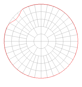 | ||||||||||||||||||
| Azimuth | Ratio | Azimuth | Ratio | Azimuth | Ratio | Azimuth | Ratio | ||||||||||||
| 0 | 1.000 | 10 | 1.000 | 20 | 1.000 | 30 | 1.000 | ||||||||||||
| 40 | 1.000 | 50 | 1.000 | 60 | 1.000 | 70 | 1.000 | ||||||||||||
| 80 | 1.000 | 90 | 1.000 | 100 | 1.000 | 110 | 1.000 | ||||||||||||
| 120 | 1.000 | 130 | 1.000 | 140 | 1.000 | 150 | 1.000 | ||||||||||||
| 160 | 1.000 | 170 | 1.000 | 180 | 1.000 | 190 | 1.000 | ||||||||||||
| 200 | 1.000 | 210 | 1.000 | 220 | 1.000 | 230 | 1.000 | ||||||||||||
| 240 | 1.000 | 250 | 1.000 | 260 | 1.000 | 270 | 1.000 | ||||||||||||
| 280 | 1.000 | 290 | 1.000 | 300 | 0.970 | 310 | 0.900 | ||||||||||||
| 320 | 0.920 | 330 | 1.000 | 340 | 1.000 | 350 | 1.000 | ||||||||||||
Structure Registration Number 1285653 Structure Type: GTOWER Registered To: WEST VIRGINIA EDUCATIONAL BROADCASTING AUTHORITY Structure Address: Located Off An Unnamed Dirt Road Located 15.3 Km Nw Of Davis Wv Davis, WV County Name: Tucker County ASR Issued: 11/02/2012 Date Built: 11/08/2013 Site Elevation: 1132.6 m (3716 ft.) Structure Height: 93 m (305 ft.) Height Overall: 94.2 m (309 ft.) Overall Height AMSL: 1226.8 m (4025 ft.) FAA Determination: 08/10/2012 FAA Study #: 2012-AEA-3712-OE FAA Circular #: 70/7460-1K Paint & Light FAA Chapters: 4, 6, 12 Removed expiration date from determination. Scenario 1./jjs/case#635066 39-11-06.2 N 79-18-14.4 W (NAD 83) 39-11-05.8 N 79-18-15.2 W (Converted to NAD 27) |
600 Capitol Street Charleston, WV 25301-1223 Phone: 304-556-4903 Fax: 304-556-4980 Not-for-Profit | Date: 03/14/2013 Application Certifier WEST VIRGINIA EDUCATIONAL BROADCASTING AUTHORITY 600 Capitol Street Charleston, WV 25301-1223 Applicant RYAN WILHOUR 507 Nw 60th Street Suite D Gainesville, FL 32607 CONSULTING ENGINEER TOM W. DAVIDSON, ESQ. Akin Gump Strauss Hauer & Feld Llp | |||||||||||||||||