
FCCInfo.com
A Service of Cavell, Mertz & Associates, Inc.
(855) FCC-INFO
|
|
K229CT from 12/20/2001 K229CT from 08/07/1985 |
|
|
||||||||||||||||
|
|
K229CT Channel: 229D 93.7 MHz Las Vegas, Nevada Service: FX - A translator or application for a translator. Facility ID: 56170 Fac. Service: FX Programming Delivery Method: Unspecified Status: License Application Accepted: 09/25/2015 Application Granted: 10/15/2015 File Number: BLFT-20150925AAA License Expires: 00/00/0000 Prefix Type: This is a license for a translator Application Type: License To Cover FCC Website Links: LMS Facility Details This Application CDBS Application Other K229CT Applications Other K229CT Applications in CDBS Including Superseded Applications Mailing Address Correspondence for K229CT Correspondence related to application BLFT-20150925AAA Service Contour - Open Street Map or USGS Map (60 dBu) Service Contour - KML / Google Earth (60 dBu) Class: D, A Noncommercial educational operating with no more than 10W Site Location: 35-56-44.9 N 115-02-38.0 W (NAD 83) Site Location: 35-56-45.0 N 115-02-35.0 W (Converted to NAD 27) Effective Radiated Power: 0.25 kW Transmitter Output Power: 0.157 kW Antenna Center HAAT: 0 m Antenna Center AMSL: 1339 m (4393 ft.) Antenna Center HAG: 18 m (59 ft.) Site Elevation: 1321 m. (4334 ft.) Height Overall*: 83 m (272 ft.) (* As Filed In This Application, may differ from ASR Data, Below.) Directional Antenna Antenna Make/Model: None Antenna ID: 121993 Polarization:
| ||||||||||||||||||
| Antenna Data for Antenna Id: 121993 K229CT FX File: BLFT-20150925AAA None - Service: FX Pattern and Field Values Include a 298° Clockwise Rotation | 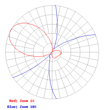 | ||||||||||||||||||
| Azimuth | Ratio | Azimuth | Ratio | Azimuth | Ratio | Azimuth | Ratio | ||||||||||||
| 8 | 0.076 | 18 | 0.032 | 28 | 0.008 | 38 | 0.011 | ||||||||||||
| 48 | 0.022 | 58 | 0.050 | 68 | 0.099 | 78 | 0.150 | ||||||||||||
| 88 | 0.185 | 98 | 0.193 | 108 | 0.181 | 118 | 0.161 | ||||||||||||
| 128 | 0.147 | 138 | 0.144 | 148 | 0.145 | 158 | 0.141 | ||||||||||||
| 168 | 0.122 | 178 | 0.088 | 188 | 0.044 | 198 | 0.014 | ||||||||||||
| 208 | 0.012 | 218 | 0.007 | 228 | 0.040 | 238 | 0.116 | ||||||||||||
| 248 | 0.247 | 258 | 0.427 | 268 | 0.632 | 278 | 0.823 | ||||||||||||
| 288 | 0.953 | 298 | 0.998 | 308 | 0.954 | 318 | 0.830 | ||||||||||||
| 328 | 0.654 | 338 | 0.461 | 348 | 0.286 | 358 | 0.156 | ||||||||||||
Structure Registration Number 1010825 Structure Type: TOWER Registered To: Nexstar Media Inc. Structure Address: Black Mountain Henderson, NV County Name: Clark County ASR Issued: 05/28/2021 Date Built: 05/01/2012 Site Elevation: 1321.3 m (4335 ft.) Structure Height: 58.8 m (193 ft.) Height Overall: 82.6 m (271 ft.) Overall Height AMSL: 1403.9 m (4606 ft.) FAA Determination: 04/23/2012 FAA Study #: 2012-AWP-2509-OE FAA Circular #: 70/7460-1K Paint & Light FAA Chapters: 3, 4, 5, 12 35-56-45.1 N 115-02-38.3 W (NAD 83) 35-56-45.2 N 115-02-35.3 W (Converted to NAD 27) |
P. O Box 747 Lake Havasu City, AZ 8604-0747 Phone: 928-855-9110 | Date: 09/25/2015 Application Certifier RICHARD D, TATHAM 2141 Bryce Drive Lake Havasu City, AZ 86404 Applicant GENE WISNIEWSKI 1472 East 3100 South Wendell, ID 83355 CONSULTING ENGINEER FARON ECKELBATRGER Arizona Broadcast Engineering Services 3110 Crater Drive Lake Havasu City, AZ 86403 | |||||||||||||||||