
FCCInfo.com
A Service of Cavell, Mertz & Associates, Inc.
(855) FCC-INFO
|
|
WCUG from 12/01/2009 WCUG from 08/16/2002 |
|
|
||||||||||||||||
|
|
WCUG Channel: 203C2 88.5 MHz Lumpkin, Georgia Service: FM - A full-service FM station or application. Facility ID: 88005 Fac. Service: FM Status: License Application Accepted: 03/26/2008 Application Granted: 04/03/2008 File Number: BLED-20080326AHV License Expires: 00/00/0000 Prefix Type: This is a license for a noncommercial educational FM station Application Type: License To Cover FCC Website Links: LMS Facility Details This Application CDBS Application Other WCUG Applications Other WCUG Applications in CDBS Including Superseded Applications Mailing Address Correspondence for WCUG Correspondence related to application BLED-20080326AHV Service Contour - Open Street Map or USGS Map (60 dBu) Service Contour - KML / Google Earth (60 dBu) Public Inspection Files Facility Type: NON-COMMERCIAL EDUC. FM Class: C2, A Zone II station; with 25kW-50kW ERP and a class contour distance 39km-52km Site Location: 31-59-19.6 N 84-55-58.7 W (NAD 83) Site Location: 31-59-19.0 N 84-55-59.0 W (Converted to NAD 27) Effective Radiated Power: 23 kW Transmitter Output Power: 6.669 kW Antenna Center HAAT: 164 m (538 ft.) Antenna Center AMSL: 278 m (912 ft.) Antenna Center HAG: 111 m (364 ft.) Calculated Site Elevation: 167 m. (548 ft.) Height Overall*: 142 m (466 ft.) (* As Filed In This Application, may differ from ASR Data, Below.) Directional Antenna Antenna Make/Model: Electronics Research Inc. 1091-2CP-DA, Two Sections Antenna ID: 80738 Polarization: | ||||||||||||||||||
| Antenna Data for Antenna Id: 80738 WCUG FM File: BLED-20080326AHV Electronics Research Inc. - 1091-2CP-DA, Two Sections Service: FM | 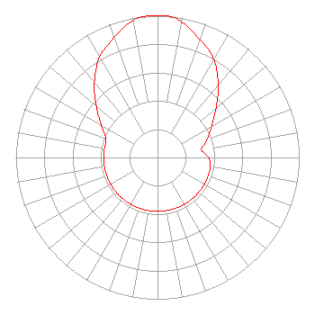 | ||||||||||||||||||
| Azimuth | Ratio | Azimuth | Ratio | Azimuth | Ratio | Azimuth | Ratio | ||||||||||||
| 0 | 1.000 | 5 | 1.000 | 10 | 0.971 | 20 | 0.882 | ||||||||||||
| 30 | 0.797 | 40 | 0.667 | 50 | 0.540 | 60 | 0.443 | ||||||||||||
| 70 | 0.373 | 80 | 0.315 | 90 | 0.362 | 100 | 0.380 | ||||||||||||
| 110 | 0.380 | 120 | 0.380 | 130 | 0.380 | 140 | 0.380 | ||||||||||||
| 150 | 0.380 | 160 | 0.380 | 170 | 0.380 | 180 | 0.380 | ||||||||||||
| 190 | 0.380 | 200 | 0.380 | 210 | 0.380 | 220 | 0.380 | ||||||||||||
| 230 | 0.380 | 240 | 0.380 | 250 | 0.380 | 260 | 0.380 | ||||||||||||
| 270 | 0.380 | 280 | 0.380 | 290 | 0.387 | 300 | 0.460 | ||||||||||||
| 310 | 0.563 | 320 | 0.693 | 330 | 0.818 | 340 | 0.899 | ||||||||||||
| 350 | 0.982 | 355 | 1.000 | ||||||||||||||||
Structure Registration Number 1020134 [ASR Heights Differ from WCUG Application] Structure Type: GTOWER Registered To: Public Service Towers, Inc. Structure Address: Hwy 27 1 Mi Ne Sanford, GA County Name: Stewart County ASR Issued: 05/16/2018 Date Built: 04/10/2018 Site Elevation: 167 m (548 ft.) Structure Height: 123.2 m (404 ft.) Height Overall: 123.2 m (404 ft.) Overall Height AMSL: 290.2 m (952 ft.) FAA Determination: 05/10/2018 FAA Study #: 2018-ASO-8473-OE FAA Circular #: 70/7460-1H Paint & Light FAA Chapters: 4, 6, 13 PRIOR STUDY 1994-ASO-3039-OE 31-59-18.1 N 84-55-59.2 W (NAD 83) 31-59-17.5 N 84-55-59.5 W (Converted to NAD 27) |
P.o. Box 5657 Columbus, GA 31906 Phone: 706-575-2754 | Date: 03/26/2008 Application Certifier SPANISH CULTURAL EDUCATION, INC. P. O. Box 9382 Columbus, GA 31908-9382 Applicant JAMES W. POLLOCK Radiotechniques, L.l.c. P.o. Box 367 Haddon Heights, NJ 08035-0367 CONSULTING ENGINEER MELODIE A. VIRTUE, ESQ. Garvey Schubert Barer | |||||||||||||||||
| |||||||||||||||||||