
FCCInfo.com
A Service of Cavell, Mertz & Associates, Inc.
(855) FCC-INFO
|
|
|
|
|
||||||||||||||||
|
|
W235BW Channel: 235D 94.9 MHz Nashville, Tennessee Service: FX - A translator or application for a translator. Facility ID: 142861 Fac. Service: FX Programming Delivery Method: Unspecified Status: License Application Accepted: 10/24/2013 Application Granted: 11/21/2013 File Number: BLFT-20131024ALB License Expires: 00/00/0000 Prefix Type: This is a license for a translator Application Type: License To Cover FCC Website Links: LMS Facility Details This Application CDBS Application Other W235BW Applications Other W235BW Applications in CDBS Including Superseded Applications Mailing Address Correspondence for W235BW Correspondence related to application BLFT-20131024ALB Service Contour - Open Street Map or USGS Map (60 dBu) Service Contour - KML / Google Earth (60 dBu) Class: D, A Noncommercial educational operating with no more than 10W Site Location: 36-08-27.2 N 86-51-56.0 W (NAD 83) Site Location: 36-08-27.0 N 86-51-56.0 W (Converted to NAD 27) Effective Radiated Power: 0.25 kW Transmitter Output Power: 0.806 kW Antenna Center HAAT: 0 m Antenna Center AMSL: 418 m (1371 ft.) Antenna Center HAG: 212 m (696 ft.) Site Elevation: 206 m. (676 ft.) Height Overall*: 417 m (1368 ft.) (* As Filed In This Application, may differ from ASR Data, Below.) Directional Antenna Antenna Make/Model: None Antenna ID: 115078 Polarization:
| ||||||||||||||||||
| Antenna Data for Antenna Id: 115078 W235BW FX File: BLFT-20131024ALB None - Service: FX | 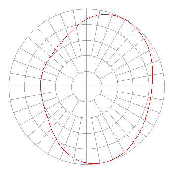 | ||||||||||||||||||
| Azimuth | Ratio | Azimuth | Ratio | Azimuth | Ratio | Azimuth | Ratio | ||||||||||||
| 0 | 0.864 | 10 | 0.932 | 20 | 0.974 | 30 | 0.991 | ||||||||||||
| 40 | 0.985 | 50 | 0.962 | 60 | 0.929 | 70 | 0.893 | ||||||||||||
| 80 | 0.862 | 90 | 0.842 | 100 | 0.837 | 110 | 0.845 | ||||||||||||
| 120 | 0.868 | 130 | 0.901 | 140 | 0.936 | 150 | 0.972 | ||||||||||||
| 160 | 0.994 | 170 | 0.999 | 180 | 0.979 | 190 | 0.935 | ||||||||||||
| 200 | 0.864 | 210 | 0.779 | 220 | 0.702 | 230 | 0.645 | ||||||||||||
| 240 | 0.611 | 250 | 0.596 | 260 | 0.592 | 270 | 0.594 | ||||||||||||
| 280 | 0.596 | 290 | 0.596 | 300 | 0.596 | 310 | 0.601 | ||||||||||||
| 320 | 0.617 | 330 | 0.651 | 340 | 0.707 | 350 | 0.781 | ||||||||||||
Structure Registration Number 1050735 Structure Type: GTOWER Registered To: Gray Media Group, Inc. Structure Address: 5700 Knob Road Nashville, TN County Name: Davidson County ASR Issued: 12/02/2021 Date Built: 01/01/1986 Site Elevation: 205.7 m (675 ft.) Structure Height: 391.4 m (1284 ft.) Height Overall: 417.4 m (1369 ft.) Overall Height AMSL: 623.1 m (2044 ft.) FAA Determination: 01/28/2021 FAA Study #: 2020-ASO-36673-OE FAA Circular #: 70/7460-1M Paint & Light FAA Chapters: 3, 4, 5, 15 PRIOR STUDY 1998-ASO-1912-OE 36-08-27.0 N 86-51-56.0 W (NAD 83) 36-08-26.8 N 86-51-56.0 W (Converted to NAD 27) |
P.o. Box 150846 Nashville, TN 37215 Phone: 615-361-7560 Corporation | Date: 10/24/2013 Application Certifier WYCQ, INC. P.o. Box 150846 Nashville, TN 37215 Applicant CHARLES M. ANDERSON Anderson Associates 1519 Euclid Avenue Bowling Green, KY 42103 CONSULTANT JOHN GARZIGLIA Womble Carlyle Sandridge & Rice, Llp 1200 19th Street, N.w., Suite 500 Washington, DC 20036 | |||||||||||||||||