
FCCInfo.com
A Service of Cavell, Mertz & Associates, Inc.
(855) FCC-INFO
|
|
|
|
|
||||||||||||||||
|
|
K232CI Channel: 232D 94.3 MHz Missoula, Montana Service: FX - A translator or application for a translator. Facility ID: 146259 Fac. Service: FX Programming Delivery Method: Unspecified Status: License Application Accepted: 04/08/2015 Application Granted: 04/27/2015 File Number: BLFT-20150408ADF License Expires: 00/00/0000 Prefix Type: This is a license for a translator Application Type: License To Cover FCC Website Links: LMS Facility Details This Application CDBS Application Other K232CI Applications Other K232CI Applications in CDBS Including Superseded Applications Mailing Address Correspondence for K232CI Correspondence related to application BLFT-20150408ADF Service Contour - Open Street Map or USGS Map (60 dBu) Service Contour - KML / Google Earth (60 dBu) Class: D, A Noncommercial educational operating with no more than 10W Site Location: 46-48-08.7 N 113-58-24.4 W (NAD 83) Site Location: 46-48-09.0 N 113-58-21.0 W (Converted to NAD 27) Effective Radiated Power: 0.25 kW Transmitter Output Power: 0.16 kW Antenna Center HAAT: 0 m Antenna Center AMSL: 1902 m (6240 ft.) Antenna Center HAG: 11 m (36 ft.) Site Elevation: 1891 m. (6204 ft.) Height Overall*: 19 m (62 ft.) (* As Filed In This Application, may differ from ASR Data, Below.) Directional Antenna Antenna Make/Model: None Antenna ID: 120209 Polarization:
| ||||||||||||||||||
| Antenna Data for Antenna Id: 120209 K232CI FX File: BLFT-20150408ADF None - Service: FX | 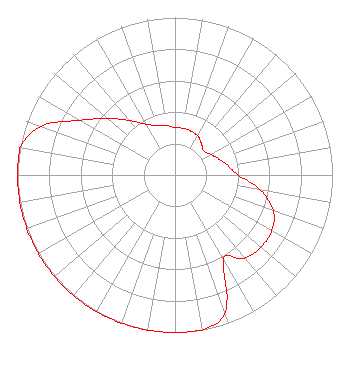 | ||||||||||||||||||
| Azimuth | Ratio | Azimuth | Ratio | Azimuth | Ratio | Azimuth | Ratio | ||||||||||||
| 0 | 0.301 | 10 | 0.301 | 20 | 0.297 | 30 | 0.287 | ||||||||||||
| 40 | 0.260 | 50 | 0.238 | 60 | 0.262 | 70 | 0.297 | ||||||||||||
| 80 | 0.342 | 90 | 0.400 | 100 | 0.550 | 110 | 0.665 | ||||||||||||
| 120 | 0.709 | 130 | 0.712 | 140 | 0.691 | 150 | 0.614 | ||||||||||||
| 160 | 0.929 | 170 | 1.000 | 180 | 1.000 | 190 | 1.000 | ||||||||||||
| 200 | 1.000 | 210 | 1.000 | 220 | 1.000 | 230 | 1.000 | ||||||||||||
| 240 | 1.000 | 250 | 1.000 | 260 | 1.000 | 270 | 1.000 | ||||||||||||
| 280 | 1.000 | 290 | 0.903 | 300 | 0.695 | 310 | 0.560 | ||||||||||||
| 320 | 0.452 | 330 | 0.373 | 340 | 0.335 | 350 | 0.318 | ||||||||||||
Structure Registration Number 1047704 Structure Type: POLE Registered To: HICKMAN SITES LLC Structure Address: Atop Dean Stone Mountain Missoula, MT County Name: Missoula County ASR Issued: 05/18/1998 Date Built: 01/01/1997 Site Elevation: 1890.7 m (6203 ft.) Structure Height: 19.2 m (63 ft.) Height Overall: 19.2 m (63 ft.) Overall Height AMSL: 1909.9 m (6266 ft.) FAA Determination: 10/24/1997 FAA Study #: 97-ANM-1292-OE Paint & Light FAA Chapters: NONE Removed expiration date from determination. Scenario 1./jjs/case#635066 46-48-09.0 N 113-58-24.0 W (NAD 83) 46-48-09.3 N 113-58-20.6 W (Converted to NAD 27) |
4111 Plains Blvd Amarillo, TX 79106 Phone: 208-733-3551 | Date: 04/08/2015 Application Certifier EDGEWATER BROADCASTING, INC. 160 Gooding St. West Suite B Twin Falls, ID 83301 Applicant GENE WISNIEWSKI 160 Gooding Street West Suite A Twin Falls, ID 83301 CONSULTING ENGINEER CLARK PARRISH Edgewater Broadcasting, Inc. 160 Gooding St. West Suite B Twin Falls, ID 83301 | |||||||||||||||||