
FCCInfo.com
A Service of Cavell, Mertz & Associates, Inc.
(855) FCC-INFO
|
|
|
|  |
|
|||||||||||||||
|
|
KCKH Channel: 240C3 95.9 MHz Mansfield, Missouri Service: FM - A full-service FM station or application. Facility ID: 14065 Fac. Service: FM Status: License 73.215 Station Application Accepted: 07/10/2018 Application Granted: 08/17/2018 File Number: BMLED-20180710AAF License Expires: 00/00/0000 Prefix Type: This is a modification of license for a noncommercial educational FM station Application Type: Minor Modification FCC Website Links: LMS Facility Details This Application CDBS Application Other KCKH Applications Other KCKH Applications in CDBS Including Superseded Applications Mailing Address Correspondence for KCKH Correspondence related to application BMLED-20180710AAF Service Contour - Open Street Map or USGS Map (60 dBu) Service Contour - KML / Google Earth (60 dBu) Public Inspection Files History Cards for KCKH Facility Type: NON-COMMERCIAL EDUC. FM Class: C3, A Zone II station; with 6kW-25kW ERP and a class contour distance 28km-39km Site Location: 37-17-10.2 N 92-36-55.6 W (NAD 83) Site Location: 37-17-10.0 N 92-36-55.0 W (Converted to NAD 27) Effective Radiated Power: 8.9 kW Transmitter Output Power: 3 kW Antenna Center HAAT: 165 m (541 ft.) Antenna Center AMSL: 583 m (1913 ft.) Antenna Center HAG: 147 m (482 ft.) Calculated Site Elevation: 436 m. (1430 ft.) Height Overall*: 152.4 m (500 ft.) (* As Filed In This Application, may differ from ASR Data, Below.) Directional Antenna Antenna Make/Model: Shivley 6810-4R-DA Antenna ID: 78101 Polarization: | ||||||||||||||||||
| Antenna Data for Antenna Id: 78101 KCKH FM File: BMLED-20180710AAF Shivley - 6810-4R-DA Service: FM | 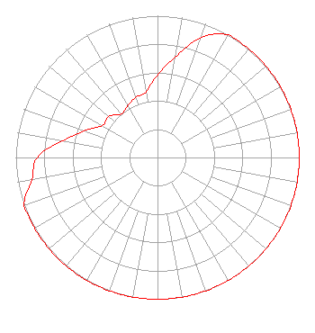 | ||||||||||||||||||
| Azimuth | Ratio | Azimuth | Ratio | Azimuth | Ratio | Azimuth | Ratio | ||||||||||||
| 0 | 0.580 | 10 | 0.720 | 20 | 0.900 | 30 | 1.000 | ||||||||||||
| 40 | 1.000 | 50 | 1.000 | 60 | 1.000 | 70 | 1.000 | ||||||||||||
| 80 | 1.000 | 90 | 1.000 | 100 | 1.000 | 110 | 1.000 | ||||||||||||
| 120 | 1.000 | 130 | 1.000 | 140 | 1.000 | 150 | 1.000 | ||||||||||||
| 160 | 1.000 | 170 | 1.000 | 180 | 1.000 | 190 | 1.000 | ||||||||||||
| 200 | 1.000 | 210 | 1.000 | 220 | 1.000 | 230 | 1.000 | ||||||||||||
| 240 | 1.000 | 250 | 1.000 | 260 | 0.900 | 270 | 0.850 | ||||||||||||
| 280 | 0.680 | 290 | 0.550 | 300 | 0.450 | 310 | 0.450 | ||||||||||||
| 320 | 0.400 | 330 | 0.420 | 340 | 0.450 | 350 | 0.470 | ||||||||||||
Structure Registration Number 1243731 [ASR Heights Differ from KCKH Application] Structure Type: GTOWER Registered To: UNIVERSITY OF NORTHWESTERN - ST. PAUL Structure Address: 0.19 Miles Se Of Hampton Rd./kendrick Rd. Intersection Hartville, MO County Name: Wright County ASR Issued: 07/05/2023 Date Built: 09/01/2018 Site Elevation: 442.9 m (1453 ft.) Structure Height: 151.4 m (497 ft.) Height Overall: 152.4 m (500 ft.) Overall Height AMSL: 595.3 m (1953 ft.) FAA Determination: 09/25/2018 FAA Study #: 2018-ACE-6568-OE FAA Circular #: 70/7460-1L Paint & Light FAA Chapters: 3, 4, 5, 12 PRIOR STUDY 2007-ACE-472-OE 37-17-12.3 N 92-37-14.0 W (NAD 83) 37-17-12.1 N 92-37-13.4 W (Converted to NAD 27) |
3003 Snelling Ave N Saint Paul, MN 55113 Phone: 651-631-5009 Not-for-Profit | Date: 07/10/2018 Application Certifier LAKE AREA EDUCATIONAL BROADCASTING FOUNDATION P. O. Box 800 Camdenton, MO 65020-0800 Applicant JAMES MCDERMOTT Po Box 800 Camdenton, MO 65020-0800 CHIEF ENGINEER JAMES J MCDERMOTT Lake Area Educational Broadcasting Foundation | |||||||||||||||||