
FCCInfo.com
A Service of Cavell, Mertz & Associates, Inc.
(855) FCC-INFO
|
|
KKSP from 05/14/2003 KKSP from 10/05/1999 KKSP from 05/01/1998 KKSP from 11/08/1988 |
|  |
|
|||||||||||||||
|
|
KKSP Channel: 227C3 93.3 MHz Bryant, Arkansas Service: FM - A full-service FM station or application. Facility ID: 39751 Fac. Service: FM Status: License 73.215 Station Application Accepted: 06/08/2016 Application Granted: 06/17/2016 File Number: BLH-20160608HTG License Expires: 00/00/0000 Prefix Type: This is a license for a commercial FM station Application Type: License To Cover FCC Website Links: LMS Facility Details This Application CDBS Application Other KKSP Applications Other KKSP Applications in CDBS Including Superseded Applications Mailing Address Correspondence for KKSP Correspondence related to application BLH-20160608HTG Service Contour - Open Street Map or USGS Map (60 dBu) Service Contour - KML / Google Earth (60 dBu) Public Inspection Files Facility Type: FM STATION Class: C3, A Zone II station; with 6kW-25kW ERP and a class contour distance 28km-39km Site Location: 34-44-37.3 N 92-19-07.5 W (NAD 83) Site Location: 34-44-37.0 N 92-19-07.0 W (Converted to NAD 27) Effective Radiated Power: 22 kW Transmitter Output Power: 10.14 kW Antenna Center HAAT: 107 m (351 ft.) Antenna Center AMSL: 207 m (679 ft.) Antenna Center HAG: 82 m (269 ft.) Calculated Site Elevation: 125 m. (410 ft.) Height Overall*: 97.5 m (320 ft.) (* As Filed In This Application, may differ from ASR Data, Below.) Directional Antenna Antenna Make/Model: Shivley 6810-4R-SS(0.5)-DA, 4 bays, .5 wavelength spaced Antenna ID: 124738 Polarization: | ||||||||||||||||||
| Antenna Data for Antenna Id: 124738 KKSP FM File: BLH-20160608HTG Shivley - 6810-4R-SS(0.5)-DA, 4 bays, .5 wavelength spaced Service: FM | 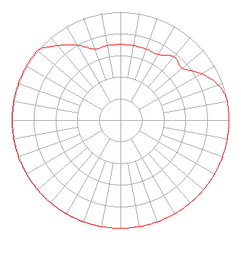 | ||||||||||||||||||
| Azimuth | Ratio | Azimuth | Ratio | Azimuth | Ratio | Azimuth | Ratio | ||||||||||||
| 0 | 0.700 | 10 | 0.700 | 20 | 0.700 | 30 | 0.700 | ||||||||||||
| 40 | 0.765 | 50 | 0.748 | 60 | 0.861 | 70 | 0.958 | ||||||||||||
| 80 | 1.000 | 90 | 1.000 | 100 | 1.000 | 110 | 1.000 | ||||||||||||
| 120 | 1.000 | 130 | 1.000 | 140 | 1.000 | 150 | 1.000 | ||||||||||||
| 160 | 1.000 | 170 | 1.000 | 180 | 1.000 | 190 | 1.000 | ||||||||||||
| 200 | 1.000 | 210 | 1.000 | 220 | 1.000 | 230 | 1.000 | ||||||||||||
| 240 | 1.000 | 250 | 1.000 | 260 | 1.000 | 270 | 1.000 | ||||||||||||
| 280 | 1.000 | 290 | 1.000 | 300 | 1.000 | 310 | 1.000 | ||||||||||||
| 320 | 0.900 | 330 | 0.800 | 340 | 0.700 | 350 | 0.700 | ||||||||||||
Structure Registration Number 1038484 [ASR Heights Differ from KKSP Application] Structure Type: LTOWER Registered To: VB Nimbus, LLC Structure Address: 4021 West Eight Street Little Rock, AR County Name: Pulaski County ASR Issued: 11/19/2020 Date Built: 08/01/1994 Site Elevation: 125 m (410 ft.) Structure Height: 91.4 m (300 ft.) Height Overall: 95 m (312 ft.) Overall Height AMSL: 220 m (722 ft.) FAA Determination: 11/12/2020 FAA Study #: 2020-ASW-14825-OE FAA Circular #: 70/7460-1L Paint & Light FAA Chapters: 4, 8, 12 OM&L to remain the same as prior study = A MED-DUAL SYSTEM 34-44-37.9 N 92-19-06.6 W (NAD 83) 34-44-37.6 N 92-19-06.1 W (Converted to NAD 27) |
4880 Santa Rosa Road Camarillo, CA 93012 Phone: 805-987-0400 | Date: 06/08/2016 Application Certifier SOUTH TEXAS BROADCASTING, INC. 4880 Santa Rosa Road Camarillo, CA 93012 Applicant WILLIAM J. GETZ Carl T. Jones Corporation 7901 Yarnwood Ct Springfield, VA 22153 CONSULTING ENGINEER FRANK R. JAZZO, ESQ. Fletcher, Heald & Hildreth, P.l.c. | |||||||||||||||||
| |||||||||||||||||||