
FCCInfo.com
A Service of Cavell, Mertz & Associates, Inc.
(855) FCC-INFO
|
|
W266BU from 12/11/2009 W266BU from 03/07/2000 |
|
|
||||||||||||||||
|
|
W266BU Channel: 266D 101.1 MHz Mount Pleasant, Michigan Service: FX - A translator or application for a translator. Facility ID: 94015 Fac. Service: FX Programming Delivery Method: Unspecified Status: License Application Accepted: 05/18/2010 Application Granted: 05/26/2010 File Number: BLFT-20100518ABB License Expires: 00/00/0000 Prefix Type: This is a license for a translator Application Type: License To Cover FCC Website Links: LMS Facility Details This Application CDBS Application Other W266BU Applications Other W266BU Applications in CDBS Including Superseded Applications Mailing Address Correspondence for W266BU Correspondence related to application BLFT-20100518ABB Service Contour - Open Street Map or USGS Map (60 dBu) Service Contour - KML / Google Earth (60 dBu) Class: D, A Noncommercial educational operating with no more than 10W Site Location: 43-34-33.1 N 84-46-29.0 W (NAD 83) Site Location: 43-34-33.0 N 84-46-28.9 W (Converted to NAD 27) Effective Radiated Power: 0 kW Horiz. ; 0.12 kW Vert. Transmitter Output Power: 0.081 kW Antenna Center HAAT: 0 m Horiz.; 138.7 m Vert. Antenna Center AMSL: 0 m Horiz.; 380 m Vert. Antenna Center HAG: 0 m Horiz.; 137 m Vert. Site Elevation: 243 m. (797 ft.) Height Overall*: 169 m (554 ft.) (* As Filed In This Application, may differ from ASR Data, Below.) Directional Antenna Antenna Make/Model: None Antenna ID: 97006 Polarization:
| ||||||||||||||||||
| Antenna Data for Antenna Id: 97006 W266BU FX File: BLFT-20100518ABB None - Service: FX | 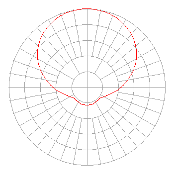 | ||||||||||||||||||
| Azimuth | Ratio | Azimuth | Ratio | Azimuth | Ratio | Azimuth | Ratio | ||||||||||||
| 0 | 1.000 | 10 | 0.990 | 20 | 0.970 | 30 | 0.930 | ||||||||||||
| 40 | 0.880 | 50 | 0.810 | 60 | 0.730 | 70 | 0.630 | ||||||||||||
| 80 | 0.530 | 90 | 0.440 | 100 | 0.360 | 110 | 0.290 | ||||||||||||
| 120 | 0.250 | 130 | 0.220 | 140 | 0.220 | 150 | 0.220 | ||||||||||||
| 160 | 0.230 | 170 | 0.230 | 180 | 0.230 | 190 | 0.230 | ||||||||||||
| 200 | 0.230 | 210 | 0.220 | 220 | 0.220 | 230 | 0.220 | ||||||||||||
| 240 | 0.250 | 250 | 0.290 | 260 | 0.360 | 270 | 0.440 | ||||||||||||
| 280 | 0.530 | 290 | 0.630 | 300 | 0.730 | 310 | 0.810 | ||||||||||||
| 320 | 0.880 | 330 | 0.930 | 340 | 0.970 | 350 | 0.990 | ||||||||||||
Structure Registration Number 1002165 Structure Type: TOWER Registered To: CMU Public Broadcasting Structure Address: 64 Km W Of Blue Grass Rd Old Us Rt 27 Mount Pleasant, MI County Name: Isabella County ASR Issued: 10/04/2016 Date Built: 04/16/2010 Site Elevation: 242.9 m (797 ft.) Structure Height: 168.2 m (552 ft.) Height Overall: 169.2 m (555 ft.) Overall Height AMSL: 412.1 m (1352 ft.) FAA Determination: 09/14/2007 FAA Study #: 2007-AGL-7003-OE FAA Circular #: 70/7460-1G Paint & Light FAA Chapters: 3, 4, 5, 9 PRIOR STUDY 1991-AGL-579-OE 43-34-33.0 N 84-46-29.0 W (NAD 83) 43-34-32.9 N 84-46-28.9 W (Converted to NAD 27) |
340 Moore Hall Mt. Pleasant, MI 48859 Phone: 989-774-3851 | Date: 05/18/2010 Application Certifier CENTRAL MICHIGAN UNIVERSITY 340 Moore Hall Mt. Pleasant, MI 48859 Applicant JUSTIN W. ASHER Munn-reese, Inc. Po Box 220, 385 Airport Dr. Coldwater, MI 49036-0220 CONSULTING ENGINEER ALAN C. CAMPBELL, ESQ. Fletcher, Heald & Hildreth, P.l.c. 1300 North 17th Street 11th Floor Arlington, VA 22209 | |||||||||||||||||