
FCCInfo.com
A Service of Cavell, Mertz & Associates, Inc.
(855) FCC-INFO
|
|
WNOC from 02/27/2009 |
|  |
|
|||||||||||||||
|
|
WNOC Channel: 209A 89.7 MHz Bowling Green, Ohio Service: FM - A full-service FM station or application. Facility ID: 176349 Fac. Service: FM Status: License Application Accepted: 08/24/2010 Application Granted: 08/27/2010 File Number: BLED-20100824AAT License Expires: 00/00/0000 Prefix Type: This is a license for a noncommercial educational FM station Application Type: License To Cover FCC Website Links: LMS Facility Details This Application CDBS Application Other WNOC Applications Other WNOC Applications in CDBS Including Superseded Applications Mailing Address Correspondence for WNOC Correspondence related to application BLED-20100824AAT Service Contour - Open Street Map or USGS Map (60 dBu) Service Contour - KML / Google Earth (60 dBu) Public Inspection Files Facility Type: NON-COMMERCIAL EDUC. FM Class: A, A Zone I; I-A; or II station; with 0.1kW-6kW ERP and a class contour distance <=28km Site Location: 41-25-39.2 N 83-36-29.8 W (NAD 83) Site Location: 41-25-39.0 N 83-36-30.0 W (Converted to NAD 27) Effective Radiated Power: 5.3 kW Transmitter Output Power: 2.45 kW Antenna Center HAAT: 87.9 m (288 ft.) Antenna Center AMSL: 289.2 m (949 ft.) Antenna Center HAG: 86.8 m (285 ft.) Calculated Site Elevation: 202.4 m. (664 ft.) Height Overall*: 108 m (354 ft.) (* As Filed In This Application, may differ from ASR Data, Below.) Directional Antenna Antenna Make/Model: Propagation System Inc FMR-3-DA, three sections, 0.5 wavelength spacing Antenna ID: 98480 Polarization:
| ||||||||||||||||||
| Antenna Data for Antenna Id: 98480 WNOC FM File: BLED-20100824AAT Propagation System Inc - FMR-3-DA, three sections, 0.5 wavelength spacing Service: FM | 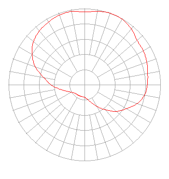 | ||||||||||||||||||
| Azimuth | Ratio | Azimuth | Ratio | Azimuth | Ratio | Azimuth | Ratio | ||||||||||||
| 0 | 0.953 | 10 | 0.977 | 20 | 0.998 | 30 | 0.991 | ||||||||||||
| 40 | 0.956 | 50 | 0.903 | 60 | 0.892 | 70 | 0.871 | ||||||||||||
| 80 | 0.844 | 90 | 0.826 | 100 | 0.802 | 110 | 0.733 | ||||||||||||
| 120 | 0.633 | 130 | 0.547 | 140 | 0.429 | 150 | 0.331 | ||||||||||||
| 160 | 0.246 | 170 | 0.190 | 180 | 0.166 | 190 | 0.161 | ||||||||||||
| 200 | 0.160 | 210 | 0.161 | 220 | 0.162 | 230 | 0.172 | ||||||||||||
| 240 | 0.199 | 250 | 0.250 | 260 | 0.331 | 270 | 0.441 | ||||||||||||
| 280 | 0.545 | 290 | 0.690 | 300 | 0.795 | 310 | 0.877 | ||||||||||||
| 320 | 0.921 | 330 | 0.948 | 340 | 0.970 | 350 | 0.976 | ||||||||||||
Structure Registration Number 1270580 Structure Type: TOWER Registered To: SBA Towers V, LLC Structure Address: 2.4 Nautical Miles Ne Of Airport Reference Point From The Wood County Airport Bowling Green, OH County Name: Wood County ASR Issued: 06/25/2014 Date Built: 08/05/2010 Site Elevation: 202.4 m (664 ft.) Structure Height: 108.2 m (355 ft.) Height Overall: 108.2 m (355 ft.) Overall Height AMSL: 310.6 m (1019 ft.) FAA Determination: 09/09/2009 FAA Study #: 2009-AGL-4189-OE FAA Circular #: 70/7460-1K Paint & Light FAA Chapters: 4, 8, 12 PRIOR STUDY 2009-AGL-624-OE 41-25-38.9 N 83-36-30.2 W (NAD 83) 41-25-38.7 N 83-36-30.4 W (Converted to NAD 27) |
Post Office Box 504 Ann Arbor, MI 48106-9902 Phone: 734-930-3167 Not-for-Profit | Date: 08/24/2010 Application Certifier OUR LADY OF GUADALUPE RADIO, INC., DBA ANNUNCIATION RADIO 2679 Brookford Toledo, OH 43614 Applicant ROBERT M. PETERS 426 West Ludwig Road Fort Wayne, IN 46825 CONSULTING ENGINEER STUART W. NOLAN, JR., ESQ. Legalworks Apostolate, Pllc | |||||||||||||||||