
FCCInfo.com
A Service of Cavell, Mertz & Associates, Inc.
(855) FCC-INFO
|
|
|
|  |
|
|||||||||||||||
|
|
KVRS Channel: 212C3 90.3 MHz Lawton, Oklahoma Service: FM - A full-service FM station or application. Facility ID: 36822 Fac. Service: FM Status: License Application Accepted: 11/19/2009 Application Granted: 03/02/2010 File Number: BLED-20091119AAM License Expires: 00/00/0000 Prefix Type: This is a license for a noncommercial educational FM station Application Type: Amendment FCC Website Links: LMS Facility Details This Application CDBS Application Other KVRS Applications Other KVRS Applications in CDBS Including Superseded Applications Mailing Address Correspondence for KVRS Correspondence related to application BLED-20091119AAM Service Contour - Open Street Map or USGS Map (60 dBu) Service Contour - KML / Google Earth (60 dBu) Public Inspection Files Facility Type: NON-COMMERCIAL EDUC. FM Class: C3, A Zone II station; with 6kW-25kW ERP and a class contour distance 28km-39km Site Location: 34-31-51.3 N 98-33-11.2 W (NAD 83) Site Location: 34-31-51.0 N 98-33-10.0 W (Converted to NAD 27) Effective Radiated Power: 0 kW Horiz. ; 9.8 kW Vert. Transmitter Output Power: 1.082 kW Antenna Center HAAT: 0 m Horiz.; 80 m Vert. Antenna Center AMSL: 0 m Horiz.; 430 m Vert. Antenna Center HAG: 0 m Horiz.; 81 m Vert. Site Elevation: 349 m. (1145 ft.) Height Overall*: 91.4 m (300 ft.) (* As Filed In This Application, may differ from ASR Data, Below.) Directional Antenna Antenna Make/Model: Shivley 6513-5-DA, five sections Antenna ID: 89929 Polarization: | ||||||||||||||||||
| Antenna Data for Antenna Id: 89929 KVRS FM File: BLED-20091119AAM Shivley - 6513-5-DA, five sections Service: FM | 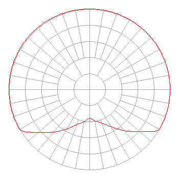 | ||||||||||||||||||
| Azimuth | Ratio | Azimuth | Ratio | Azimuth | Ratio | Azimuth | Ratio | ||||||||||||
| 0 | 1.000 | 10 | 1.000 | 20 | 1.000 | 30 | 1.000 | ||||||||||||
| 40 | 1.000 | 50 | 1.000 | 60 | 1.000 | 70 | 1.000 | ||||||||||||
| 80 | 1.000 | 90 | 1.000 | 100 | 1.000 | 110 | 1.000 | ||||||||||||
| 120 | 1.000 | 130 | 0.812 | 140 | 0.668 | 150 | 0.534 | ||||||||||||
| 160 | 0.443 | 170 | 0.398 | 180 | 0.359 | 190 | 0.411 | ||||||||||||
| 200 | 0.467 | 210 | 0.571 | 220 | 0.692 | 230 | 0.836 | ||||||||||||
| 240 | 1.000 | 250 | 1.000 | 260 | 1.000 | 270 | 1.000 | ||||||||||||
| 280 | 1.000 | 290 | 1.000 | 300 | 1.000 | 310 | 1.000 | ||||||||||||
| 320 | 1.000 | 330 | 1.000 | 340 | 1.000 | 350 | 1.000 | ||||||||||||
Structure Registration Number 1265655 Structure Type: TOWER Registered To: AMERICAN FAMILY ASSOCIATION Structure Address: 13121 Sw Pecan Road Lawton, OK County Name: Comanche County ASR Issued: 02/01/2010 Date Built: 08/21/2009 Site Elevation: 349 m (1145 ft.) Structure Height: 91.4 m (300 ft.) Height Overall: 91.4 m (300 ft.) Overall Height AMSL: 440.4 m (1445 ft.) FAA Determination: 01/27/2010 FAA Study #: 2009-ASW-6025-OE FAA Circular #: 70/7460-1K Paint & Light FAA Chapters: 4, 8, 12 PRIOR STUDY 2009-ASW-3770-OE 34-31-51.0 N 98-33-11.0 W (NAD 83) 34-31-50.7 N 98-33-09.8 W (Converted to NAD 27) |
P.o. Drawer 2440 Tupelo, MS 38803 Phone: 662-844-8888 Not-for-Profit | Date: 11/19/2009 Application Certifier AMERICAN FAMILY ASSOCIATION P.o. Drawer 2440 Tupelo, MS 38801 Applicant JESSICA HUCKABY P.o. Drawer 2440 Tupelo, MS 38803 TECHNICAL CONSULTANT JESSICA HUCKABY American Family Association | |||||||||||||||||