
FCCInfo.com
A Service of Cavell, Mertz & Associates, Inc.
(855) FCC-INFO
|
|
K298AZ from 11/06/2007 K298AZ from 09/27/2007 K298AZ from 08/30/2007 K298AZ from 03/26/2007 K298AZ from 08/19/2004 |
|
|
||||||||||||||||
|
|
K298AZ Channel: 298D 107.5 MHz Santa Rosa, California Service: FX - A translator or application for a translator. Facility ID: 147493 Fac. Service: FX Programming Delivery Method: Unspecified Status: License Application Accepted: 08/06/2009 Application Granted: 08/12/2009 File Number: BLFT-20090806ACQ License Expires: 00/00/0000 Prefix Type: This is a license for a translator Application Type: License To Cover FCC Website Links: LMS Facility Details This Application CDBS Application Other K298AZ Applications Other K298AZ Applications in CDBS Including Superseded Applications Mailing Address Correspondence for K298AZ Correspondence related to application BLFT-20090806ACQ Service Contour - Open Street Map or USGS Map (60 dBu) Service Contour - KML / Google Earth (60 dBu) Class: D, A Noncommercial educational operating with no more than 10W Site Location: 38-30-30.7 N 122-39-44.9 W (NAD 83) Site Location: 38-30-31.0 N 122-39-41.0 W (Converted to NAD 27) Effective Radiated Power: 0.017 kW Transmitter Output Power: 0.05 kW Antenna Center HAAT: 318.5 m Horiz.; 0 m Vert. Antenna Center AMSL: 538 m (1765 ft.) Antenna Center HAG: 50 m (164 ft.) Site Elevation: 488 m. (1601 ft.) Height Overall*: 62 m (203 ft.) (* As Filed In This Application, may differ from ASR Data, Below.) Directional Antenna Antenna Make/Model: None Antenna ID: 94405 Polarization:
| ||||||||||||||||||
| Antenna Data for Antenna Id: 94405 K298AZ FX File: BLFT-20090806ACQ None - Service: FX Pattern and Field Values Include a 220° Clockwise Rotation | 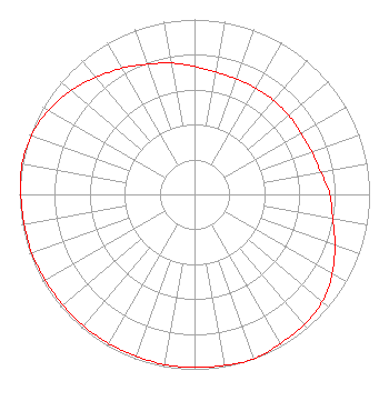 | ||||||||||||||||||
| Azimuth | Ratio | Azimuth | Ratio | Azimuth | Ratio | Azimuth | Ratio | ||||||||||||
| 0 | 0.732 | 10 | 0.710 | 20 | 0.702 | 30 | 0.702 | ||||||||||||
| 40 | 0.702 | 50 | 0.702 | 60 | 0.702 | 70 | 0.712 | ||||||||||||
| 80 | 0.732 | 90 | 0.772 | 100 | 0.802 | 110 | 0.853 | ||||||||||||
| 120 | 0.909 | 130 | 0.953 | 140 | 0.973 | 150 | 0.983 | ||||||||||||
| 160 | 1.000 | 170 | 0.992 | 180 | 0.988 | 190 | 0.988 | ||||||||||||
| 200 | 0.983 | 210 | 0.983 | 220 | 0.983 | 230 | 0.983 | ||||||||||||
| 240 | 0.983 | 250 | 0.988 | 260 | 0.988 | 270 | 0.992 | ||||||||||||
| 280 | 1.000 | 290 | 0.991 | 300 | 0.963 | 310 | 0.923 | ||||||||||||
| 320 | 0.873 | 330 | 0.832 | 340 | 0.792 | 350 | 0.762 | ||||||||||||
Structure Registration Number 1000695 [ASR Heights Differ from K298AZ Application] Structure Type: GTOWER Registered To: SBA Towers V, LLC Structure Address: 2179 Calistoga Rd (ca15528-a) Santa Rosa, CA County Name: Sonoma County ASR Issued: 11/16/2022 Date Built: 02/01/1972 Site Elevation: 479.8 m (1574 ft.) Structure Height: 61 m (200 ft.) Height Overall: 67.7 m (222 ft.) Overall Height AMSL: 547.5 m (1796 ft.) FAA Determination: 11/14/2022 FAA Study #: 2022-AWP-20227-OE FAA Circular #: 70/7460-1M Paint & Light FAA Chapters: 4, 8, 15 PRIOR STUDY 2014-AWP-3348-OE 38-30-32.1 N 122-39-48.0 W (NAD 83) 38-30-32.4 N 122-39-44.1 W (Converted to NAD 27) |
868 N. Garfield Ave Montebello, CA 90640 Phone: 213-745-6224 Corporation | Date: 08/06/2009 Application Certifier MOON BROADCASTING LICENSEE, LLC 1200 W. Venice Blvd. Los Angeles, CA 90006 Applicant SCOTT C. CINNAMON Scott C. Cinnamon 1250 Connecticut Ave., N.w.. Suite 200, # 144 Washington, DC 20036 KEITH J. LEITCH P.o. Box 1118 Santa Rosa, CA 95402 ENGINEER | |||||||||||||||||