
FCCInfo.com
A Service of Cavell, Mertz & Associates, Inc.
(855) FCC-INFO
|
|
|
|  |
|
|||||||||||||||
|
|
WYBO Channel: 225A 92.9 MHz Waynesboro, Georgia Service: FM - A full-service FM station or application. Facility ID: 166071 Fac. Service: FM Status: License 73.215 Station Application Accepted: 03/22/2016 Application Granted: 03/29/2016 File Number: BLH-20160322ADT License Expires: 00/00/0000 Prefix Type: This is a license for a commercial FM station Application Type: Amendment FCC Website Links: LMS Facility Details This Application CDBS Application Other WYBO Applications Other WYBO Applications in CDBS Including Superseded Applications Mailing Address Correspondence for WYBO Correspondence related to application BLH-20160322ADT Service Contour - Open Street Map or USGS Map (60 dBu) Service Contour - KML / Google Earth (60 dBu) Public Inspection Files Facility Type: FM STATION Class: A, A Zone I; I-A; or II station; with 0.1kW-6kW ERP and a class contour distance <=28km Site Location: 33-13-06.4 N 82-02-31.1 W (NAD 83) Site Location: 33-13-05.9 N 82-02-31.7 W (Converted to NAD 27) Effective Radiated Power: 4.3 kW Transmitter Output Power: 2.13 kW Antenna Center HAAT: 99 m (325 ft.) Antenna Center AMSL: 181.2 m (594 ft.) Antenna Center HAG: 101.2 m (332 ft.) Calculated Site Elevation: 80 m. (262 ft.) Height Overall*: 103.6 m (340 ft.) (* As Filed In This Application, may differ from ASR Data, Below.) Directional Antenna Antenna Make/Model: Systems With Reliability Inc. FM3/2-0.75WS-DA Antenna ID: 123468 Polarization: | ||||||||||||||||||
| Antenna Data for Antenna Id: 123468 WYBO FM File: BLH-20160322ADT Systems With Reliability Inc. - FM3/2-0.75WS-DA Service: FM | 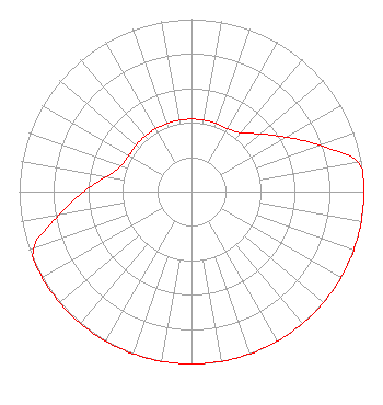 | ||||||||||||||||||
| Azimuth | Ratio | Azimuth | Ratio | Azimuth | Ratio | Azimuth | Ratio | ||||||||||||
| 0 | 0.420 | 10 | 0.420 | 20 | 0.420 | 30 | 0.420 | ||||||||||||
| 40 | 0.445 | 50 | 0.520 | 60 | 0.630 | 70 | 0.787 | ||||||||||||
| 80 | 0.980 | 90 | 1.000 | 100 | 1.000 | 110 | 1.000 | ||||||||||||
| 120 | 1.000 | 130 | 1.000 | 140 | 1.000 | 150 | 1.000 | ||||||||||||
| 160 | 1.000 | 170 | 1.000 | 180 | 1.000 | 190 | 1.000 | ||||||||||||
| 200 | 1.000 | 210 | 1.000 | 220 | 1.000 | 230 | 1.000 | ||||||||||||
| 240 | 1.000 | 250 | 0.976 | 260 | 0.781 | 270 | 0.625 | ||||||||||||
| 280 | 0.500 | 290 | 0.435 | 300 | 0.420 | 310 | 0.420 | ||||||||||||
| 320 | 0.420 | 330 | 0.420 | 340 | 0.420 | 350 | 0.420 | ||||||||||||
Structure Registration Number 1047293 Structure Type: TOWER Registered To: SBA Towers, LLC Structure Address: 4256 Hwy 25 North Hephzibah, GA County Name: Burke County ASR Issued: 04/26/2013 Date Built: 08/06/1998 Site Elevation: 79.9 m (262 ft.) Structure Height: 97.5 m (320 ft.) Height Overall: 103.6 m (340 ft.) Overall Height AMSL: 183.5 m (602 ft.) FAA Determination: 03/06/2003 FAA Study #: 2003-ASO-473-OE FAA Circular #: 70/7460-1J Paint & Light FAA Chapters: 4, 5, 6, 8, 13 PRIOR STUDY 1998-ASO-3625-OE 33-13-06.4 N 82-02-31.1 W (NAD 83) 33-13-05.9 N 82-02-31.7 W (Converted to NAD 27) |
650 Pinchtown Road Montgomery, PA 17752 Phone: 570-547-1131 Individual | Date: 03/22/2016 Application Certifier JOHN SMITH 650 Pinchtown Road Montgomery, PA 17752 Applicant ROBERT HUNNICUTT 2397 Highway 25 North Keysville, GA 30816 ENGINEER JEFFREY L. TIMMONS, ESQ. Jeffrey L. Timmons, P.c. | |||||||||||||||||