
FCCInfo.com
A Service of Cavell, Mertz & Associates, Inc.
(855) FCC-INFO
|
|
|
|  |
|
|||||||||||||||
|
|
WLJW-FM Channel: 240C2 95.9 MHz Fife Lake, Michigan Service: FM - A full-service FM station or application. Facility ID: 190434 Fac. Service: FM Status: License 73.215 Station Application Accepted: 02/07/2014 Application Granted: 02/28/2014 File Number: BLED-20140207ABG License Expires: 00/00/0000 Prefix Type: This is a license for a noncommercial educational FM station Application Type: License To Cover FCC Website Links: LMS Facility Details This Application CDBS Application Other WLJW-FM Applications Other WLJW-FM Applications in CDBS Including Superseded Applications Mailing Address Correspondence for WLJW-FM Correspondence related to application BLED-20140207ABG Service Contour - Open Street Map or USGS Map (60 dBu) Service Contour - KML / Google Earth (60 dBu) Public Inspection Files Facility Type: NON-COMMERCIAL EDUC. FM Class: C2, A Zone II station; with 25kW-50kW ERP and a class contour distance 39km-52km Site Location: 44-35-41.0 N 85-11-53.2 W (NAD 83) Site Location: 44-35-41.0 N 85-11-53.0 W (Converted to NAD 27) Effective Radiated Power: 19 kW Transmitter Output Power: 5.41 kW Antenna Center HAAT: 249 m (817 ft.) Antenna Center AMSL: 581.5 m (1908 ft.) Antenna Center HAG: 167.6 m (550 ft.) Calculated Site Elevation: 413.9 m. (1358 ft.) Height Overall*: 210.6 m (691 ft.) (* As Filed In This Application, may differ from ASR Data, Below.) Directional Antenna Antenna Make/Model: Electronics Research Inc. MP-5E-DA, five sections Antenna ID: 109820 Polarization: | ||||||||||||||||||
| Antenna Data for Antenna Id: 109820 WLJW-FM FM File: BLED-20140207ABG Electronics Research Inc. - MP-5E-DA, five sections Service: FM | 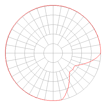 | ||||||||||||||||||
| Azimuth | Ratio | Azimuth | Ratio | Azimuth | Ratio | Azimuth | Ratio | ||||||||||||
| 0 | 1.000 | 10 | 1.000 | 20 | 1.000 | 30 | 1.000 | ||||||||||||
| 40 | 1.000 | 50 | 1.000 | 60 | 1.000 | 70 | 1.000 | ||||||||||||
| 80 | 1.000 | 90 | 1.000 | 100 | 0.855 | 110 | 0.679 | ||||||||||||
| 120 | 0.540 | 130 | 0.540 | 140 | 0.540 | 150 | 0.679 | ||||||||||||
| 160 | 0.855 | 170 | 1.000 | 180 | 1.000 | 190 | 1.000 | ||||||||||||
| 200 | 1.000 | 210 | 1.000 | 220 | 1.000 | 230 | 1.000 | ||||||||||||
| 240 | 1.000 | 250 | 1.000 | 260 | 1.000 | 270 | 1.000 | ||||||||||||
| 280 | 1.000 | 290 | 1.000 | 300 | 1.000 | 310 | 1.000 | ||||||||||||
| 320 | 1.000 | 330 | 1.000 | 340 | 1.000 | 350 | 1.000 | ||||||||||||
Structure Registration Number 1220711 Structure Type: GTOWER Registered To: WKJF Radio, Inc. Structure Address: 1 Kilometer North Of Giddings, MI County Name: Kalkaska County ASR Issued: 07/06/2020 Date Built: 07/16/2020 Site Elevation: 413.9 m (1358 ft.) Structure Height: 209.7 m (688 ft.) Height Overall: 210.6 m (691 ft.) Overall Height AMSL: 624.5 m (2049 ft.) FAA Determination: 11/20/2019 FAA Study #: 2019-AGL-16874-OE FAA Circular #: 70/7460-1L Paint & Light FAA Chapters: 3, 4, 5, 12 PRIOR STUDY 1999-AGL-3583-OE 44-35-41.0 N 85-11-53.2 W (NAD 83) 44-35-41.0 N 85-11-53.0 W (Converted to NAD 27) |
1511 M-32 East Po Box 695 Gaylord, MI 49734 Phone: 989-732-6274 Not-for-Profit | Date: 02/07/2014 Application Certifier GOOD NEWS MEDIA, INC. Po Box 1408 Traverse City, MI 49685-1408 Applicant JOHN J. MULLANEY Mullaney Engineering, Inc. 9049 Shady Grove Court Gaithersburg, MD 20877 CONSULTING ENGINEER JEFFREY D. SOUTHMAYD Southmayd & Miller | |||||||||||||||||
| |||||||||||||||||||