
FCCInfo.com
A Service of Cavell, Mertz & Associates, Inc.
(855) FCC-INFO
|
|
|
|
|
||||||||||||||||
|
|
WDTP Channel: 208A 89.5 MHz Huron Township, Michigan Service: FM - A full-service FM station or application. Facility ID: 176302 Fac. Service: FM Status: License Application Accepted: 05/26/2011 Application Granted: 06/15/2011 File Number: BLED-20110526AJF License Expires: 00/00/0000 Prefix Type: This is a license for a noncommercial educational FM station Application Type: License To Cover FCC Website Links: LMS Facility Details This Application CDBS Application Other WDTP Applications Other WDTP Applications in CDBS Including Superseded Applications Mailing Address Correspondence for WDTP Correspondence related to application BLED-20110526AJF Service Contour - Open Street Map or USGS Map (60 dBu) Service Contour - KML / Google Earth (60 dBu) Public Inspection Files Facility Type: NON-COMMERCIAL EDUC. FM Class: A, A Zone I; I-A; or II station; with 0.1kW-6kW ERP and a class contour distance <=28km Site Location: 42-09-44.1 N 83-12-19.7 W (NAD 83) Site Location: 42-09-44.0 N 83-12-20.0 W (Converted to NAD 27) Effective Radiated Power: 0.7 kW Transmitter Output Power: 0.85 kW Antenna Center HAAT: 95 m (312 ft.) Antenna Center AMSL: 273 m (896 ft.) Antenna Center HAG: 92 m (302 ft.) Calculated Site Elevation: 181 m. (594 ft.) Height Overall*: 99 m (325 ft.) (* As Filed In This Application, may differ from ASR Data, Below.) Directional Antenna Antenna Make/Model: ETC FM-1-DA Antenna ID: 101590 Polarization:
| ||||||||||||||||||
| Antenna Data for Antenna Id: 101590 WDTP FM File: BLED-20110526AJF ETC - FM-1-DA Service: FM | 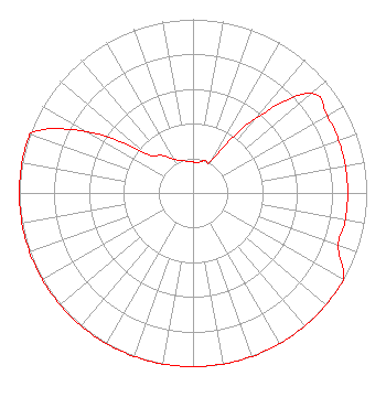 | ||||||||||||||||||
| Azimuth | Ratio | Azimuth | Ratio | Azimuth | Ratio | Azimuth | Ratio | ||||||||||||
| 0 | 0.178 | 10 | 0.178 | 20 | 0.200 | 30 | 0.224 | ||||||||||||
| 40 | 0.562 | 50 | 0.891 | 60 | 0.891 | 70 | 0.891 | ||||||||||||
| 80 | 0.891 | 90 | 0.891 | 100 | 0.891 | 110 | 0.891 | ||||||||||||
| 120 | 1.000 | 130 | 1.000 | 140 | 1.000 | 150 | 1.000 | ||||||||||||
| 160 | 1.000 | 170 | 1.000 | 180 | 1.000 | 190 | 1.000 | ||||||||||||
| 200 | 1.000 | 210 | 1.000 | 220 | 1.000 | 230 | 1.000 | ||||||||||||
| 240 | 1.000 | 250 | 1.000 | 260 | 1.000 | 270 | 1.000 | ||||||||||||
| 280 | 1.000 | 290 | 1.000 | 300 | 0.708 | 310 | 0.355 | ||||||||||||
| 320 | 0.282 | 330 | 0.224 | 340 | 0.200 | 350 | 0.185 | ||||||||||||
Structure Registration Number 1001046 [ASR Heights Differ from WDTP Application] Structure Type: TOWER Registered To: City of Riverview Structure Address: 20863 Grange Riverview, MI County Name: Wayne County ASR Issued: 03/13/2012 Date Built: 09/16/1994 Site Elevation: 181 m (594 ft.) Structure Height: 99 m (325 ft.) Height Overall: 103 m (338 ft.) Overall Height AMSL: 284 m (932 ft.) FAA Determination: 02/24/2012 FAA Study #: 2012-AGL-1099-OE FAA Circular #: 70/7460-1H Paint & Light FAA Chapters: 4, 8, 13 OM&L to remain the same as prior study = A MED-DUAL SYSTEM 42-09-44.0 N 83-12-20.0 W (NAD 83) 42-09-43.9 N 83-12-20.3 W (Converted to NAD 27) |
172 N Cedar St Imlay City, MI 48444 Phone: 810-895-2040 Not-for-Profit | Date: 05/26/2011 Application Certifier SMILE FM 3302 N. Van Dyke Imlay City, MI 48444 Applicant EDWARD CZELADA 3302 N. Van Dyke Rd. Imlay City, MI 48444 PRESIDENT EDWARD CZELADA Smile Fm | |||||||||||||||||