
FCCInfo.com
A Service of Cavell, Mertz & Associates, Inc.
(855) FCC-INFO
|
|
W268BN from 03/26/2010 W268BN from 04/05/2004 |
|
|
||||||||||||||||
|
|
W268BN Channel: 268D 101.5 MHz Dickson, Tennessee Service: FX - A translator or application for a translator. Facility ID: 140472 Fac. Service: FX Programming Delivery Method: Unspecified Status: License Application Accepted: 10/07/2011 Application Granted: 10/27/2011 File Number: BLFT-20111007ADA License Expires: 00/00/0000 Prefix Type: This is a license for a translator Application Type: License To Cover FCC Website Links: LMS Facility Details This Application CDBS Application Other W268BN Applications Other W268BN Applications in CDBS Including Superseded Applications Mailing Address Correspondence for W268BN Correspondence related to application BLFT-20111007ADA Service Contour - Open Street Map or USGS Map (60 dBu) Service Contour - KML / Google Earth (60 dBu) Class: D, A Noncommercial educational operating with no more than 10W Site Location: 36-06-31.2 N 87-22-14.0 W (NAD 83) Site Location: 36-06-31.0 N 87-22-14.0 W (Converted to NAD 27) Effective Radiated Power: 0.25 kW Transmitter Output Power: 0.315 kW Antenna Center HAAT: 105.1 m Horiz.; 0 m Vert. Antenna Center AMSL: 332 m (1089 ft.) Antenna Center HAG: 78 m (256 ft.) Site Elevation: 254 m. (833 ft.) Height Overall*: 81 m (266 ft.) (* As Filed In This Application, may differ from ASR Data, Below.) Directional Antenna Antenna Make/Model: None Antenna ID: 106430 Polarization:
| ||||||||||||||||||
| Antenna Data for Antenna Id: 106430 W268BN FX File: BLFT-20111007ADA None - Service: FX | 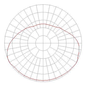 | ||||||||||||||||||
| Azimuth | Ratio | Azimuth | Ratio | Azimuth | Ratio | Azimuth | Ratio | ||||||||||||
| 0 | 0.493 | 10 | 0.493 | 20 | 0.493 | 30 | 0.507 | ||||||||||||
| 40 | 0.536 | 50 | 0.596 | 60 | 0.643 | 70 | 0.728 | ||||||||||||
| 80 | 0.826 | 90 | 0.908 | 100 | 0.947 | 110 | 0.966 | ||||||||||||
| 120 | 1.000 | 130 | 0.984 | 140 | 0.976 | 150 | 0.966 | ||||||||||||
| 160 | 0.966 | 170 | 0.966 | 180 | 0.966 | 190 | 0.966 | ||||||||||||
| 200 | 0.966 | 210 | 0.966 | 220 | 0.966 | 230 | 0.966 | ||||||||||||
| 240 | 1.000 | 250 | 0.982 | 260 | 0.927 | 270 | 0.852 | ||||||||||||
| 280 | 0.762 | 290 | 0.692 | 300 | 0.627 | 310 | 0.581 | ||||||||||||
| 320 | 0.536 | 330 | 0.498 | 340 | 0.493 | 350 | 0.493 | ||||||||||||
Structure Registration Number 1227950 Structure Type: TOWER Registered To: R & F COMMUNICATIONS, INC. Structure Address: Hwy 48 Dickson, TN County Name: Dickson County ASR Issued: 07/19/2023 Date Built: 07/07/1985 Site Elevation: 253.6 m (832 ft.) Structure Height: 80.8 m (265 ft.) Height Overall: 80.8 m (265 ft.) Overall Height AMSL: 334.4 m (1097 ft.) FAA Determination: 01/11/1980 FAA Study #: 80-ASO-63-OE Paint & Light FAA Chapters: 1, 3, 11, 21 RED LIGHTS/PAINT 36-06-31.2 N 87-22-14.0 W (NAD 83) 36-06-31.0 N 87-22-14.0 W (Converted to NAD 27) |
108 West College Street Dickson, TN 37055 Phone: 615-446-0752 Corporation | Date: 10/07/2011 Application Certifier R & F COMMUNICATIONS, INC. 106 East College St. Dickson, TN 37055 Applicant JIM TURVAVILLE 4825-104 Garden Ranch Drive Colorado Springs, CO 80918 CONSUTING ENGINEER ROBERT S. STONE, ESQ. Ramsey, Elmore & Stone, Pllc 5616 Kingston Pike Suite 301 Knoxville, TN 37919-6301 | |||||||||||||||||