
FCCInfo.com
A Service of Cavell, Mertz & Associates, Inc.
(855) FCC-INFO
|
|
KZLO from 11/29/1989 |
|
|
||||||||||||||||
|
|
KZLO Channel: 204C1 88.7 MHz Kilgore, Texas Service: FM - A full-service FM station or application. Facility ID: 34602 Fac. Service: FM Status: License Application Accepted: 03/26/1997 Application Granted: 09/30/1997 File Number: BLED-19970326KA License Expires: 00/00/0000 Prefix Type: This is a license for a noncommercial educational FM station Application Type: License To Cover FCC Website Links: LMS Facility Details This Application CDBS Application Other KZLO Applications Other KZLO Applications in CDBS Including Superseded Applications Mailing Address Correspondence for KZLO Correspondence related to application BLED-19970326KA Service Contour - Open Street Map or USGS Map (60 dBu) Service Contour - KML / Google Earth (60 dBu) Public Inspection Files Facility Type: NON-COMMERCIAL EDUC. FM Class: C1, A Zone II station; with 50kW-100kW ERP and a class contour distance 52km-72km Site Location: 32-20-14.5 N 95-02-41.8 W (NAD 83) Site Location: 32-20-14.0 N 95-02-41.0 W (Converted to NAD 27) Effective Radiated Power: 63 kW Horiz. ; 79 kW Vert. Antenna Center HAAT: 168 m (551 ft.) Antenna Center AMSL: 302 m (991 ft.) Antenna Center HAG: 126 m (413 ft.) Site Elevation: 175.9 m. (577 ft.) Height Overall*: 141.3 m (464 ft.) (* As Filed In This Application, may differ from ASR Data, Below.) Directional Antenna Antenna Make/Model: Oddball; usually designed by Applicant ODD921221MB Antenna ID: 14447 Polarization: | ||||||||||||||||||
| Antenna Data for Antenna Id: 14447 KZLO FM File: BLED-19970326KA Oddball; usually designed by Applicant - ODD921221MB Service: FM | 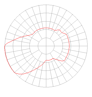 | ||||||||||||||||||
| Azimuth | Ratio | Azimuth | Ratio | Azimuth | Ratio | Azimuth | Ratio | ||||||||||||
| 0 | 0.435 | 10 | 0.435 | 20 | 0.435 | 30 | 0.435 | ||||||||||||
| 40 | 0.502 | 50 | 0.502 | 60 | 0.561 | 70 | 0.561 | ||||||||||||
| 80 | 0.561 | 90 | 0.561 | 100 | 0.561 | 110 | 0.561 | ||||||||||||
| 120 | 0.561 | 130 | 0.561 | 140 | 0.447 | 150 | 0.355 | ||||||||||||
| 160 | 0.355 | 170 | 0.355 | 180 | 0.355 | 190 | 0.447 | ||||||||||||
| 200 | 0.562 | 210 | 0.708 | 220 | 0.891 | 230 | 1.000 | ||||||||||||
| 240 | 1.000 | 250 | 1.000 | 260 | 1.000 | 270 | 1.000 | ||||||||||||
| 280 | 0.794 | 290 | 0.631 | 300 | 0.502 | 310 | 0.435 | ||||||||||||
| 320 | 0.435 | 330 | 0.435 | 340 | 0.435 | 350 | 0.435 | ||||||||||||
Structure Registration Number 1055375 Structure Type: TOWER Registered To: EDUCATIONAL MEDIA FOUNDATION Structure Address: 9.45 Km Northwest Overton, TX County Name: Smith County ASR Issued: 03/17/2010 Date Built: 03/26/1997 Site Elevation: 175.9 m (577 ft.) Structure Height: 140.6 m (461 ft.) Height Overall: 141.3 m (464 ft.) Overall Height AMSL: 317.2 m (1041 ft.) FAA Determination: 08/07/1998 FAA Study #: 98-ASW-3237-OE FAA Circular #: 70/7460-1G Paint & Light FAA Chapters: 3, 4, 5, 9 OM&L REMAINS RED LIGHTS/PAINT AS PER PREV FAA 90-ASW-0688-OE. 32-20-15.0 N 95-02-42.0 W (NAD 83) 32-20-14.5 N 95-02-41.2 W (Converted to NAD 27) |
5700 West Oaks Blvd. Rocklin, CA 95765 Phone: 916-251-1600 Not-for-Profit | Date: 03/26/1997 Application Certifier KILGORE JUNIOR COLLEGE Kilgore Junior College 904 Houston Street Kilgore, TX 75662 Applicant | |||||||||||||||||