
FCCInfo.com
A Service of Cavell, Mertz & Associates, Inc.
(855) FCC-INFO
|
|
|
|
|
||||||||||||||||
|
|
W270CE Channel: 270D 101.9 MHz Rome, Georgia Service: FX - A translator or application for a translator. Facility ID: 150667 Fac. Service: FX Programming Delivery Method: Unspecified Status: License Application Accepted: 02/13/2017 Application Granted: 04/24/2018 File Number: BLFT-20170213AAE License Expires: 00/00/0000 Prefix Type: This is a license for a translator Application Type: License To Cover FCC Website Links: LMS Facility Details This Application CDBS Application Other W270CE Applications Other W270CE Applications in CDBS Including Superseded Applications Mailing Address Correspondence for W270CE Correspondence related to application BLFT-20170213AAE Service Contour - Open Street Map or USGS Map (60 dBu) Service Contour - KML / Google Earth (60 dBu) Class: D, A Noncommercial educational operating with no more than 10W Site Location: 34-00-14.4 N 85-03-21.8 W (NAD 83) Site Location: 34-00-14.0 N 85-03-22.0 W (Converted to NAD 27) Effective Radiated Power: 0.24 kW Transmitter Output Power: 0.38 kW Antenna Center HAAT: 0 m Antenna Center AMSL: 381 m (1250 ft.) Antenna Center HAG: 152 m (499 ft.) Site Elevation: 229 m. (751 ft.) Height Overall*: 165 m (541 ft.) (* As Filed In This Application, may differ from ASR Data, Below.) Directional Antenna Antenna Make/Model: None Antenna ID: 120618 Polarization:
| ||||||||||||||||||
| Antenna Data for Antenna Id: 120618 W270CE FX File: BLFT-20170213AAE None - Service: FX Pattern and Field Values Include a 165° Clockwise Rotation | 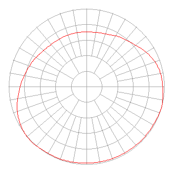 | ||||||||||||||||||
| Azimuth | Ratio | Azimuth | Ratio | Azimuth | Ratio | Azimuth | Ratio | ||||||||||||
| 5 | 0.702 | 15 | 0.712 | 25 | 0.732 | 35 | 0.772 | ||||||||||||
| 45 | 0.802 | 55 | 0.853 | 65 | 0.909 | 75 | 0.953 | ||||||||||||
| 85 | 0.973 | 95 | 0.983 | 105 | 1.000 | 115 | 0.992 | ||||||||||||
| 125 | 0.988 | 135 | 0.988 | 145 | 0.983 | 155 | 0.983 | ||||||||||||
| 165 | 0.983 | 175 | 0.983 | 185 | 0.983 | 195 | 0.988 | ||||||||||||
| 205 | 0.988 | 215 | 0.992 | 225 | 1.000 | 235 | 0.991 | ||||||||||||
| 245 | 0.963 | 255 | 0.923 | 265 | 0.873 | 275 | 0.832 | ||||||||||||
| 285 | 0.792 | 295 | 0.762 | 305 | 0.732 | 315 | 0.710 | ||||||||||||
| 325 | 0.702 | 335 | 0.702 | 345 | 0.702 | 355 | 0.702 | ||||||||||||
Structure Registration Number 1019057 Structure Type: TOWER Registered To: BROADCAST INVESTMENTS ASSOCIATES INC DBA = WZOT RADIO Structure Address: 602 West Elm St Rockmart, GA County Name: Polk County ASR Issued: 05/28/1997 Date Built: 12/31/1982 Site Elevation: 228.6 m (750 ft.) Structure Height: 163 m (535 ft.) Height Overall: 165 m (541 ft.) Overall Height AMSL: 393.6 m (1291 ft.) FAA Determination: 03/24/1983 FAA Study #: 82-ASO-2917-OE Paint & Light FAA Chapters: 1, 3, 4, 13, 21 RED LIGHTS/PAINT 34-00-14.0 N 85-03-22.0 W (NAD 83) 34-00-13.6 N 85-03-22.2 W (Converted to NAD 27) |
4111 Plains Blvd Amarillo, TX 79106 Phone: 208-733-3551 | Date: 02/13/2017 Application Certifier EDGEWATER BROADCASTING, INC. 160 W Gooding Street Twin Falls, ID 83301 Applicant CLARK PARRISH Edgewater Broadcasting, Inc. 160 W Gooding Street Twin Falls, ID 83301 GENE WISNIEWSKI 160 Gooding Street West Suite A Twin Falls, ID 83301 CONSULTING ENGINEER | |||||||||||||||||