
FCCInfo.com
A Service of Cavell, Mertz & Associates, Inc.
(855) FCC-INFO
|
|
KNBQ from 02/05/2015 |
|
|
||||||||||||||||
|
|
KNBQ Channel: 253C2 98.5 MHz Central Park, Washington Service: FM - A full-service FM station or application. Facility ID: 189496 Fac. Service: FM Status: License 73.215 Station Application Accepted: 05/03/2017 Application Granted: 07/14/2017 File Number: BMLED-20170503AAU License Expires: 00/00/0000 Prefix Type: This is a modification of license for a noncommercial educational FM station Application Type: Minor Modification FCC Website Links: LMS Facility Details This Application CDBS Application Other KNBQ Applications Other KNBQ Applications in CDBS Including Superseded Applications Mailing Address Correspondence for KNBQ Correspondence related to application BMLED-20170503AAU Service Contour - Open Street Map or USGS Map (60 dBu) Service Contour - KML / Google Earth (60 dBu) Public Inspection Files Facility Type: NON-COMMERCIAL EDUC. FM Class: C2, A Zone II station; with 25kW-50kW ERP and a class contour distance 39km-52km Site Location: 46-58-30.3 N 123-08-20.5 W (NAD 83) Site Location: 46-58-31.0 N 123-08-16.0 W (Converted to NAD 27) Effective Radiated Power: 1.6 kW Transmitter Output Power: 0.66 kW Antenna Center HAAT: 685 m (2247 ft.) Antenna Center AMSL: 885 m (2904 ft.) Antenna Center HAG: 78 m (256 ft.) Calculated Site Elevation: 807 m. (2648 ft.) Height Overall*: 93 m (305 ft.) (* As Filed In This Application, may differ from ASR Data, Below.) Directional Antenna Antenna Make/Model: Propagation System Inc FMR-6C-50WS-R-DA, 6 bays, .5 wavelength spacd Antenna ID: 124688 Polarization: | ||||||||||||||||||
| Antenna Data for Antenna Id: 124688 KNBQ FM File: BMLED-20170503AAU Propagation System Inc - FMR-6C-50WS-R-DA, 6 bays, .5 wavelength spacd Service: FM | 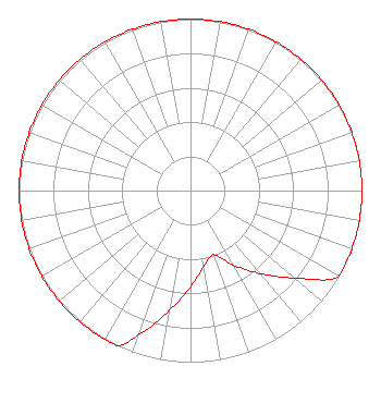 | ||||||||||||||||||
| Azimuth | Ratio | Azimuth | Ratio | Azimuth | Ratio | Azimuth | Ratio | ||||||||||||
| 0 | 1.000 | 10 | 1.000 | 20 | 1.000 | 30 | 1.000 | ||||||||||||
| 40 | 1.000 | 50 | 1.000 | 60 | 1.000 | 70 | 1.000 | ||||||||||||
| 80 | 1.000 | 90 | 1.000 | 100 | 1.000 | 110 | 1.000 | ||||||||||||
| 120 | 1.000 | 130 | 0.794 | 140 | 0.631 | 150 | 0.501 | ||||||||||||
| 160 | 0.398 | 170 | 0.447 | 180 | 0.562 | 190 | 0.708 | ||||||||||||
| 200 | 0.891 | 205 | 1.000 | 210 | 1.000 | 220 | 1.000 | ||||||||||||
| 230 | 1.000 | 240 | 1.000 | 250 | 1.000 | 260 | 1.000 | ||||||||||||
| 270 | 1.000 | 280 | 1.000 | 290 | 1.000 | 300 | 1.000 | ||||||||||||
| 310 | 1.000 | 320 | 1.000 | 330 | 1.000 | 340 | 1.000 | ||||||||||||
| 350 | 1.000 | ||||||||||||||||||
Structure Registration Number 1231674 Structure Type: TOWER Registered To: Weyerhaeuser NR Company Structure Address: Top Of Capitol Peak Littlerock, WA County Name: Thurston County ASR Issued: 10/25/2023 Date Built: 06/04/2002 Site Elevation: 806.8 m (2647 ft.) Structure Height: 91.4 m (300 ft.) Height Overall: 93 m (305 ft.) Overall Height AMSL: 899.8 m (2952 ft.) FAA Determination: 01/04/2002 FAA Study #: 98-ANM-0765-OE FAA Circular #: 70/7460-1J Paint & Light FAA Chapters: 3, 4, 5, 13 Removed expiration date from determination. Scenario 1./jjs/case#635066 46-58-30.6 N 123-08-21.0 W (NAD 83) 46-58-31.3 N 123-08-16.5 W (Converted to NAD 27) |
5700 West Oaks Blvd. Rocklin, CA 95765 Phone: 916-251-1600 Not-for-Profit | Date: 05/03/2017 Application Certifier EDUCATIONAL MEDIA FOUNDATION 5700 West Oaks Blvd. Rocklin, CA 95765 Applicant SAM WALLINGTON 5700 West Oaks Blvd. Rocklin, CA 95765 VP OF ENGINEERING MARY O'CONNOR Wilkinson Barker Knauer, Llp | |||||||||||||||||