
FCCInfo.com
A Service of Cavell, Mertz & Associates, Inc.
(855) FCC-INFO
|
|
|
|
|
||||||||||||||||
|
|
W229BY Channel: 229D 93.7 MHz Hummels Wharf, Pennsylvania Service: FX - A translator or application for a translator. Facility ID: 157268 Fac. Service: FX Programming Delivery Method: Unspecified Status: License Application Accepted: 09/12/2016 Application Granted: 09/19/2016 File Number: BLFT-20160912AAE License Expires: 00/00/0000 Prefix Type: This is a license for a translator Application Type: License To Cover FCC Website Links: LMS Facility Details This Application CDBS Application Other W229BY Applications Other W229BY Applications in CDBS Including Superseded Applications Mailing Address Correspondence for W229BY Correspondence related to application BLFT-20160912AAE Service Contour - Open Street Map or USGS Map (60 dBu) Service Contour - KML / Google Earth (60 dBu) Class: D, A Noncommercial educational operating with no more than 10W Site Location: 40-50-30.3 N 76-53-55.9 W (NAD 83) Site Location: 40-50-30.0 N 76-53-57.0 W (Converted to NAD 27) Effective Radiated Power: 0.013 kW Transmitter Output Power: 0.018 kW Antenna Center HAAT: 0 m Antenna Center AMSL: 300 m (984 ft.) Antenna Center HAG: 25 m (82 ft.) Site Elevation: 275 m. (902 ft.) Height Overall*: 38 m (125 ft.) (* As Filed In This Application, may differ from ASR Data, Below.) Directional Antenna Antenna Make/Model: None Antenna ID: 16125 Polarization:
| ||||||||||||||||||
| Antenna Data for Antenna Id: 16125 W229BY FX File: BLFT-20160912AAE None - Service: FX Pattern and Field Values Include a 90° Clockwise Rotation | 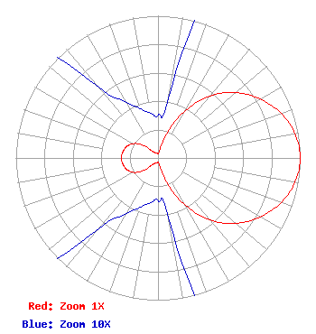 | ||||||||||||||||||
| Azimuth | Ratio | Azimuth | Ratio | Azimuth | Ratio | Azimuth | Ratio | ||||||||||||
| 0 | 0.030 | 10 | 0.045 | 20 | 0.187 | 30 | 0.388 | ||||||||||||
| 40 | 0.570 | 50 | 0.715 | 60 | 0.829 | 70 | 0.920 | ||||||||||||
| 80 | 0.979 | 90 | 1.000 | 100 | 0.979 | 110 | 0.920 | ||||||||||||
| 120 | 0.829 | 130 | 0.715 | 140 | 0.570 | 150 | 0.388 | ||||||||||||
| 160 | 0.187 | 170 | 0.045 | 180 | 0.030 | 190 | 0.032 | ||||||||||||
| 200 | 0.037 | 210 | 0.046 | 220 | 0.065 | 230 | 0.142 | ||||||||||||
| 240 | 0.202 | 250 | 0.234 | 260 | 0.250 | 270 | 0.260 | ||||||||||||
| 280 | 0.250 | 290 | 0.234 | 300 | 0.202 | 310 | 0.142 | ||||||||||||
| 320 | 0.065 | 330 | 0.046 | 340 | 0.037 | 350 | 0.032 | ||||||||||||
Structure Registration Number 1279534 Structure Type: TOWER Registered To: Beaver Springs Faith Baptist Church, Inc. Structure Address: Just East Of Intersection Of Ridge View Road & Herman Road Selinsgrove, PA County Name: Snyder County ASR Issued: 07/05/2011 Date Built: 12/19/2011 Site Elevation: 275 m (902 ft.) Structure Height: 37 m (121 ft.) Height Overall: 38 m (125 ft.) Overall Height AMSL: 313 m (1027 ft.) FAA Determination: 05/26/2011 FAA Study #: 2011-AEA-484-OE FAA Circular #: 70/7460-1K Paint & Light FAA Chapters: 4, 8, 12 Removed final date from determination. Scenario 3./jjs/case#635066 40-50-30.3 N 76-53-55.9 W (NAD 83) 40-50-30.0 N 76-53-57.0 W (Converted to NAD 27) |
1186 Sumneytown Pike Harleysville, PA 19438 Phone: 215-721-2141 | Date: 09/12/2016 Application Certifier FOUR RIVERS COMMUNITY BROADCASTING CORPORATION P.o. Box 186 Sellersville, PA 18960 Applicant CHARLES W. LOUGHERY Po Box 186 Sellersville, PA 18960 PRESIDENT/DIRECTOR OF ENGINEERING MALCOLM G. STEVENSON Schwartz, Woods & Miller Suite 900 2001 L Street N.w. Washington, DC 20036-7322 | |||||||||||||||||