
FCCInfo.com
A Service of Cavell, Mertz & Associates, Inc.
(855) FCC-INFO
|
|
|
|
|
||||||||||||||||
|
|
KXBX-FM1 Channel: 252D 98.3 MHz Ukiah, California Service: FB - A booster station or application for a booster. Facility ID: 130943 Fac. Service: FB Programming Delivery Method: Unspecified Status: License Application Accepted: 11/07/2001 Application Granted: 01/30/2002 File Number: BLFTB-20011107ABU License Expires: 00/00/0000 Prefix Type: This is a license for a booster Application Type: Amendment FCC Website Links: LMS Facility Details This Application CDBS Application Other KXBX-FM1 Applications Other KXBX-FM1 Applications in CDBS Including Superseded Applications Mailing Address Correspondence for KXBX-FM1 Correspondence related to application BLFTB-20011107ABU Service Contour - Open Street Map or USGS Map (60 dBu) Service Contour - KML / Google Earth (60 dBu) Facility Type: FM STATION Class: D, A Noncommercial educational operating with no more than 10W Site Location: 39-07-00.6 N 123-13-58.0 W (NAD 83) Site Location: 39-07-01.0 N 123-13-54.0 W (Converted to NAD 27) Effective Radiated Power: 0 kW Horiz. ; 1 kW Vert. Antenna Center HAAT: 0 m Antenna Center AMSL: 0 m Horiz.; 785 m Vert. Antenna Center HAG: 0 m Horiz.; 21 m Vert. Site Elevation: 764 m. (2507 ft.) Height Overall*: 23 m (75 ft.) (* As Filed In This Application, may differ from ASR Data, Below.) Directional Antenna Antenna Make/Model: None Antenna ID: 37706 Polarization:
| ||||||||||||||||||
| Antenna Data for Antenna Id: 37706 KXBX-FM1 FB File: BLFTB-20011107ABU None - Service: FB | 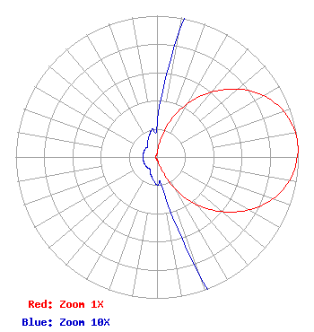 | ||||||||||||||||||
| Azimuth | Ratio | Azimuth | Ratio | Azimuth | Ratio | Azimuth | Ratio | ||||||||||||
| 0 | 0.023 | 10 | 0.092 | 20 | 0.270 | 30 | 0.442 | ||||||||||||
| 40 | 0.601 | 50 | 0.748 | 60 | 0.870 | 70 | 0.952 | ||||||||||||
| 80 | 0.993 | 85 | 1.000 | 90 | 0.993 | 100 | 0.952 | ||||||||||||
| 110 | 0.870 | 120 | 0.748 | 130 | 0.601 | 140 | 0.442 | ||||||||||||
| 150 | 0.270 | 160 | 0.092 | 170 | 0.023 | 180 | 0.020 | ||||||||||||
| 190 | 0.016 | 200 | 0.013 | 210 | 0.010 | 220 | 0.010 | ||||||||||||
| 230 | 0.010 | 240 | 0.010 | 250 | 0.010 | 260 | 0.010 | ||||||||||||
| 270 | 0.010 | 280 | 0.010 | 290 | 0.010 | 300 | 0.010 | ||||||||||||
| 310 | 0.010 | 320 | 0.010 | 330 | 0.013 | 340 | 0.016 | ||||||||||||
| 350 | 0.020 | ||||||||||||||||||
Structure Registration Number 1036896 Structure Type: TOWER Structure Address: Cleland Mountain Ukiah, CA County Name: Mendocino County ASR Issued: 03/29/2013 Date Built: 01/01/1997 Site Elevation: 764 m (2507 ft.) Structure Height: 23 m (75 ft.) Height Overall: 23 m (75 ft.) Overall Height AMSL: 787 m (2582 ft.) FAA Determination: 10/23/1997 FAA Study #: 97-AWP-2231-OE FAA Circular #: 70/7460-1J Paint & Light FAA Chapters: 3, 4, 5, 13 39-07-01.0 N 123-13-58.0 W (NAD 83) 39-07-01.4 N 123-13-54.0 W (Converted to NAD 27) |
1 Blackfield Drive # 333 Tiburon, CA 94920 Phone: 415-789-5035 | Date: 11/07/2001 Application Certifier BICOASTAL MEDIA, LLC Pmb 333 1 Blackfield Dr Tiburon, CA 94920 Applicant ERIK C. SWANSON 9500 Greenwood Ave N Seattle, WA 98103 CONSULTING ENGINEER ERWIN G. KRASNOW Verner Liipfert Bernard Mcpherson And Hand 901 15th St Nw, Ste 700 Washington, DC 20005-2301 | |||||||||||||||||