
FCCInfo.com
A Service of Cavell, Mertz & Associates, Inc.
(855) FCC-INFO
|
|
W255CT from 05/15/2012 W255CT from 07/31/1995 |
|
|
||||||||||||||||
|
|
W255CT Channel: 255D 98.9 MHz Charlottesville, Virginia Service: FX - A translator or application for a translator. Facility ID: 18875 Fac. Service: FX Programming Delivery Method: Unspecified Status: License Application Accepted: 11/24/2015 Application Granted: 12/14/2015 File Number: BLFT-20151124DQH License Expires: 00/00/0000 Prefix Type: This is a license for a translator Application Type: License To Cover FCC Website Links: LMS Facility Details This Application CDBS Application Other W255CT Applications Other W255CT Applications in CDBS Including Superseded Applications Mailing Address Correspondence for W255CT Correspondence related to application BLFT-20151124DQH Service Contour - Open Street Map or USGS Map (60 dBu) Service Contour - KML / Google Earth (60 dBu) Class: D, A Noncommercial educational operating with no more than 10W Site Location: 37-59-06.5 N 78-28-47.0 W (NAD 83) Site Location: 37-59-06.0 N 78-28-48.0 W (Converted to NAD 27) Effective Radiated Power: 0 kW Horiz. ; 0.25 kW Vert. Transmitter Output Power: 0.107 kW Antenna Center HAAT: 0 m Antenna Center AMSL: 0 m Horiz.; 483 m Vert. Antenna Center HAG: 0 m Horiz.; 49 m Vert. Site Elevation: 434 m. (1424 ft.) Height Overall*: 92 m (302 ft.) (* As Filed In This Application, may differ from ASR Data, Below.) Directional Antenna Antenna Make/Model: None Antenna ID: 122003 Polarization:
| ||||||||||||||||||
| Antenna Data for Antenna Id: 122003 W255CT FX File: BLFT-20151124DQH None - Service: FX | 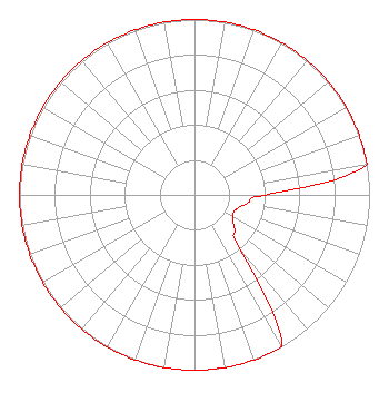 | ||||||||||||||||||
| Azimuth | Ratio | Azimuth | Ratio | Azimuth | Ratio | Azimuth | Ratio | ||||||||||||
| 0 | 1.000 | 10 | 1.000 | 20 | 1.000 | 30 | 1.000 | ||||||||||||
| 40 | 1.000 | 50 | 1.000 | 60 | 1.000 | 70 | 1.000 | ||||||||||||
| 80 | 1.000 | 90 | 0.400 | 100 | 0.300 | 110 | 0.250 | ||||||||||||
| 120 | 0.250 | 130 | 0.300 | 140 | 0.400 | 150 | 1.000 | ||||||||||||
| 160 | 1.000 | 170 | 1.000 | 180 | 1.000 | 190 | 1.000 | ||||||||||||
| 200 | 1.000 | 210 | 1.000 | 220 | 1.000 | 230 | 1.000 | ||||||||||||
| 240 | 1.000 | 250 | 1.000 | 260 | 1.000 | 270 | 1.000 | ||||||||||||
| 280 | 1.000 | 290 | 1.000 | 300 | 1.000 | 310 | 1.000 | ||||||||||||
| 320 | 1.000 | 330 | 1.000 | 340 | 1.000 | 350 | 1.000 | ||||||||||||
Structure Registration Number 1015412 Structure Type: TOWER Registered To: American Towers LLC Structure Address: 1840 Carters Mountain Trail (090228) Charlottesville, VA County Name: Albemarle County ASR Issued: 01/15/2013 Date Built: 07/25/2008 Site Elevation: 433.7 m (1423 ft.) Structure Height: 83.5 m (274 ft.) Height Overall: 92.3 m (303 ft.) Overall Height AMSL: 526 m (1726 ft.) FAA Determination: 07/25/2008 FAA Study #: 2008-AEA-1656-OE FAA Circular #: 70/7460-1K Paint & Light FAA Chapters: 4, 8, 12 OM&L to remain the same as prior study = A MED-DUAL SYSTEM 37-59-06.4 N 78-28-47.4 W (NAD 83) 37-59-05.9 N 78-28-48.4 W (Converted to NAD 27) |
73 Kercheval Avenue Grosse Pointe Farms, MI 48236 Phone: 313-886-7070 | Date: 11/24/2015 Application Certifier SAGA COMMUNICATIONS, INC. 73 Kercheval Avenue Grosse Pointe Farms, MI 48236 Applicant WAYNE S. REESE Munn-reese, Inc. P. O. Box 220 Coldwater, MI 49036-0220 CONSULTING ENGINEER GARY S. SMITHWICK, ESQUIRE Smithwick & Belendiuk, P.c. 5028 Wisconsin Avenue, N.w. Suite 301 Washington, DC 20016 | |||||||||||||||||