
FCCInfo.com
A Service of Cavell, Mertz & Associates, Inc.
(855) FCC-INFO
|
|
W224DI from 10/20/2014 W224DI from 08/04/2014 |
|
|
||||||||||||||||
|
|
W224DI Channel: 224D 92.7 MHz Indianapolis, Indiana Service: FX - A translator or application for a translator. Facility ID: 158339 Fac. Service: FX Programming Delivery Method: Unspecified Status: License Application Accepted: 04/10/2019 Application Granted: 04/15/2019 File Number: BLFT-20190410AAY License Expires: 00/00/0000 Prefix Type: This is a license for a translator Application Type: License To Cover FCC Website Links: LMS Facility Details This Application CDBS Application Other W224DI Applications Other W224DI Applications in CDBS Including Superseded Applications Mailing Address Correspondence for W224DI Correspondence related to application BLFT-20190410AAY Service Contour - Open Street Map or USGS Map (60 dBu) Service Contour - KML / Google Earth (60 dBu) Class: D, A Noncommercial educational operating with no more than 10W Site Location: 39-45-36.2 N 86-00-21.9 W (NAD 83) Site Location: 39-45-36.0 N 86-00-22.0 W (Converted to NAD 27) Effective Radiated Power: 0.25 kW Transmitter Output Power: 0.641 kW Antenna Center HAAT: 0 m Antenna Center AMSL: 512 m (1680 ft.) Antenna Center HAG: 253 m (830 ft.) Site Elevation: 259 m. (850 ft.) Height Overall*: 304 m (997 ft.) (* As Filed In This Application, may differ from ASR Data, Below.) Directional Antenna Antenna Make/Model: None Antenna ID: 132177 Polarization:
| ||||||||||||||||||
| Antenna Data for Antenna Id: 132177 W224DI FX File: BLFT-20190410AAY None - Service: FX | 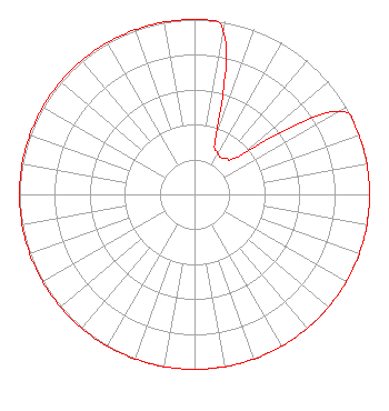 | ||||||||||||||||||
| Azimuth | Ratio | Azimuth | Ratio | Azimuth | Ratio | Azimuth | Ratio | ||||||||||||
| 0 | 1.000 | 10 | 0.950 | 20 | 0.360 | 30 | 0.270 | ||||||||||||
| 40 | 0.270 | 50 | 0.360 | 60 | 0.950 | 70 | 1.000 | ||||||||||||
| 80 | 1.000 | 90 | 1.000 | 100 | 1.000 | 110 | 1.000 | ||||||||||||
| 120 | 1.000 | 130 | 1.000 | 140 | 1.000 | 150 | 1.000 | ||||||||||||
| 160 | 1.000 | 170 | 1.000 | 180 | 1.000 | 190 | 1.000 | ||||||||||||
| 200 | 1.000 | 210 | 1.000 | 220 | 1.000 | 230 | 1.000 | ||||||||||||
| 240 | 1.000 | 250 | 1.000 | 260 | 1.000 | 270 | 1.000 | ||||||||||||
| 280 | 1.000 | 290 | 1.000 | 300 | 1.000 | 310 | 1.000 | ||||||||||||
| 320 | 1.000 | 330 | 1.000 | 340 | 1.000 | 350 | 1.000 | ||||||||||||
Structure Registration Number 1031014 Structure Type: TOWER Registered To: Vertical Bridge Towers, IV LLC Structure Address: 553 S Post Rd Indianapolis, IN County Name: Marion County ASR Issued: 11/20/2023 Date Built: 07/01/1956 Site Elevation: 259 m (850 ft.) Structure Height: 282 m (925 ft.) Height Overall: 303.9 m (997 ft.) Overall Height AMSL: 562.9 m (1847 ft.) FAA Determination: 10/24/1997 FAA Study #: 97-AGL-4554-OE FAA Circular #: 70/7460-1J Paint & Light FAA Chapters: 3, 4, 5, 13 39-45-36.0 N 86-00-22.0 W (NAD 83) 39-45-35.8 N 86-00-22.1 W (Converted to NAD 27) |
1010 Wayne Avenue, 14th Floor Silver Spring, MD 20910 Phone: 301-429-3200 | Date: 04/10/2019 Application Certifier CHARLES M. ANDERSON 1519 Euclid Avenue Bowling Green, KY 42103 Applicant CHARLES M. ANDERSON 1519 Euclid Avenue Bowling Green, KY 42103 APPLICANT/LICENSEE CHARLES M. ANDERSON Charles M. Anderson 1519 Euclid Avenue Bowling Green, KY 42103 | |||||||||||||||||