
FCCInfo.com
A Service of Cavell, Mertz & Associates, Inc.
(855) FCC-INFO
|
|
|
|  |
|
|||||||||||||||
|
|
WAYL Channel: 220A 91.9 MHz St. Augustine, Florida Service: FM - A full-service FM station or application. Facility ID: 49963 Fac. Service: FM Status: License 73.215 Station Application Accepted: 06/11/2015 Application Granted: 06/16/2015 File Number: BLED-20150611ABN License Expires: 00/00/0000 Prefix Type: This is a license for a noncommercial educational FM station Application Type: License To Cover FCC Website Links: LMS Facility Details This Application CDBS Application Other WAYL Applications Other WAYL Applications in CDBS Including Superseded Applications Mailing Address Correspondence for WAYL Correspondence related to application BLED-20150611ABN Service Contour - Open Street Map or USGS Map (60 dBu) Service Contour - KML / Google Earth (60 dBu) Public Inspection Files Facility Type: NON-COMMERCIAL EDUC. FM Class: A, A Zone I; I-A; or II station; with 0.1kW-6kW ERP and a class contour distance <=28km Site Location: 29-51-00.9 N 81-19-49.3 W (NAD 83) Site Location: 29-51-00.0 N 81-19-50.0 W (Converted to NAD 27) Effective Radiated Power: 5 kW Transmitter Output Power: 3.4 kW Antenna Center HAAT: 63 m (207 ft.) Antenna Center AMSL: 66 m (217 ft.) Antenna Center HAG: 56 m (184 ft.) Calculated Site Elevation: 10 m. (33 ft.) Height Overall*: 123.7 m (406 ft.) (* As Filed In This Application, may differ from ASR Data, Below.) Directional Antenna Antenna Make/Model: Shivley 6810-2-DA Antenna ID: 109209 Polarization: | ||||||||||||||||||
| Antenna Data for Antenna Id: 109209 WAYL FM File: BLED-20150611ABN Shivley - 6810-2-DA Service: FM | 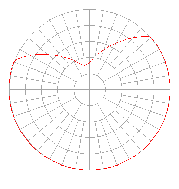 | ||||||||||||||||||
| Azimuth | Ratio | Azimuth | Ratio | Azimuth | Ratio | Azimuth | Ratio | ||||||||||||
| 0 | 0.334 | 10 | 0.421 | 20 | 0.525 | 30 | 0.661 | ||||||||||||
| 40 | 0.833 | 50 | 1.000 | 60 | 1.000 | 70 | 1.000 | ||||||||||||
| 80 | 1.000 | 90 | 1.000 | 100 | 1.000 | 110 | 1.000 | ||||||||||||
| 120 | 1.000 | 130 | 1.000 | 140 | 1.000 | 150 | 1.000 | ||||||||||||
| 160 | 1.000 | 170 | 1.000 | 180 | 1.000 | 190 | 1.000 | ||||||||||||
| 200 | 1.000 | 210 | 1.000 | 220 | 1.000 | 230 | 1.000 | ||||||||||||
| 240 | 1.000 | 250 | 1.000 | 260 | 1.000 | 270 | 1.000 | ||||||||||||
| 280 | 1.000 | 290 | 1.000 | 300 | 0.847 | 310 | 0.673 | ||||||||||||
| 320 | 0.535 | 330 | 0.425 | 340 | 0.337 | 350 | 0.303 | ||||||||||||
Structure Registration Number 1027312 [ASR Heights Differ from WAYL Application] Structure Type: GTOWER Registered To: Florida Remington Group, Inc. Structure Address: 567 Lewis Point Rd Ext Saint Augustine, FL County Name: St. Johns County ASR Issued: 03/29/2021 Date Built: 08/18/1995 Site Elevation: 9.8 m (32 ft.) Structure Height: 135.9 m (446 ft.) Height Overall: 135.9 m (446 ft.) Overall Height AMSL: 145.7 m (478 ft.) FAA Determination: 01/23/2013 FAA Study #: 2012-ASO-11549-OE FAA Circular #: 70/7460-1K Paint & Light FAA Chapters: 3, 4, 5, 12 PRIOR STUDY 1991-ASO-1277-OE 29-51-01.9 N 81-19-48.3 W (NAD 83) 29-51-01.0 N 81-19-49.0 W (Converted to NAD 27) |
3780 Will Scarlet Road Winston-salem, NC 27104 Phone: 336-765-7438 Not-for-Profit | Date: 06/11/2015 Application Certifier DELMARVA EDUCATIONAL ASSOCIATION 3780 Will Scarlet Road Winston-salem, NC 27104 Applicant WILLIAM J. GETZ Carl T. Jones Corporation 7901 Yarnwood Ct Springfield, VA 22153 CONSULTING ENGINEER DAVINA SASHKIN, ESQ. Fletcher, Heald & Hildreth, P.l.c. | |||||||||||||||||
| |||||||||||||||||||