
FCCInfo.com
A Service of Cavell, Mertz & Associates, Inc.
(855) FCC-INFO
|
|
|
|
|
||||||||||||||||
|
|
W251AO Channel: 251D 98.1 MHz Asheville, North Carolina Service: FX - A translator or application for a translator. Facility ID: 137991 Fac. Service: FX Programming Delivery Method: Unspecified Status: License Application Accepted: 04/04/2008 Application Granted: 04/25/2008 File Number: BLFT-20080404ADP License Expires: 00/00/0000 Prefix Type: This is a license for a translator Application Type: License To Cover FCC Website Links: LMS Facility Details This Application CDBS Application Other W251AO Applications Other W251AO Applications in CDBS Including Superseded Applications Mailing Address Correspondence for W251AO Correspondence related to application BLFT-20080404ADP Service Contour - Open Street Map or USGS Map (60 dBu) Service Contour - KML / Google Earth (60 dBu) Class: D, A Noncommercial educational operating with no more than 10W Site Location: 35-36-04.4 N 82-39-06.5 W (NAD 83) Site Location: 35-36-04.0 N 82-39-07.0 W (Converted to NAD 27) Effective Radiated Power: 0.25 kW Transmitter Output Power: 0.1 kW Antenna Center HAAT: 326.1 m Horiz.; 0 m Vert. Antenna Center AMSL: 1034 m (3392 ft.) Antenna Center HAG: 24 m (79 ft.) Site Elevation: 1010 m. (3314 ft.) Height Overall*: 61 m (200 ft.) (* As Filed In This Application, may differ from ASR Data, Below.) Directional Antenna Antenna Make/Model: None Antenna ID: 83691 Polarization:
| ||||||||||||||||||
| Antenna Data for Antenna Id: 83691 W251AO FX File: BLFT-20080404ADP None - Service: FX Pattern and Field Values Include a 104° Clockwise Rotation | 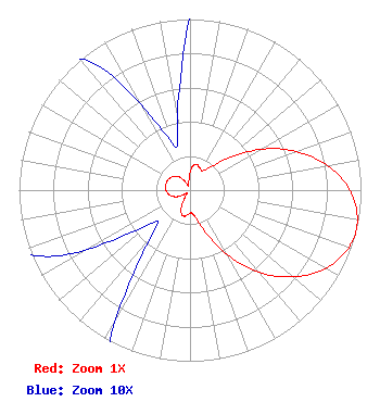 | ||||||||||||||||||
| Azimuth | Ratio | Azimuth | Ratio | Azimuth | Ratio | Azimuth | Ratio | ||||||||||||
| 4 | 0.130 | 14 | 0.157 | 24 | 0.141 | 34 | 0.138 | ||||||||||||
| 44 | 0.203 | 54 | 0.363 | 64 | 0.553 | 74 | 0.727 | ||||||||||||
| 84 | 0.871 | 94 | 0.966 | 104 | 1.000 | 114 | 0.966 | ||||||||||||
| 124 | 0.871 | 134 | 0.727 | 144 | 0.553 | 154 | 0.363 | ||||||||||||
| 164 | 0.203 | 174 | 0.138 | 184 | 0.141 | 194 | 0.157 | ||||||||||||
| 204 | 0.130 | 214 | 0.060 | 224 | 0.027 | 234 | 0.042 | ||||||||||||
| 244 | 0.088 | 254 | 0.117 | 264 | 0.134 | 274 | 0.143 | ||||||||||||
| 284 | 0.145 | 294 | 0.143 | 304 | 0.134 | 314 | 0.117 | ||||||||||||
| 324 | 0.088 | 334 | 0.042 | 344 | 0.027 | 354 | 0.060 | ||||||||||||
Structure Registration Number 1033392 Structure Type: TOWER Registered To: Pinnacle Towers LLC Structure Address: Atop Spivey Mountain At End Of Spivey Mountain Rd Asheville, NC County Name: Buncombe County ASR Issued: 05/06/2016 Date Built: 08/03/1998 Site Elevation: 1010 m (3314 ft.) Structure Height: 55 m (180 ft.) Height Overall: 61 m (200 ft.) Overall Height AMSL: 1071 m (3514 ft.) FAA Determination: 09/22/1997 FAA Study #: 97-ASO-4570-OE Paint & Light FAA Chapters: NONE 35-36-04.0 N 82-39-06.0 W (NAD 83) 35-36-03.6 N 82-39-06.5 W (Converted to NAD 27) |
73 Kercheval Avenue Grosse Pointe Farms, MI 48236 Phone: 313-886-7070 | Date: 04/04/2008 Application Certifier SAGA COMMUNICATIONS OF NORTH CAROLINA, LLC 73 Kercheval Avenue Grosse Pointe Farms, MI 48236 Applicant WILLIAM G. BROWN Bromo Communications, Inc. P.o. Box 191747 Atlanta, GA 31119-1747 TECHNICAL CONSULTANT GARY S. SMITHWICK, ESQ. Smithwick & Belendiuk, P.c. 5028 Wisconsin Avenue, Nw Suite 301 Washington, DC 20016 | |||||||||||||||||