
FCCInfo.com
A Service of Cavell, Mertz & Associates, Inc.
(855) FCC-INFO
|
|
K211DF from 06/04/1993 |
|
|
||||||||||||||||
|
|
K211DF Channel: 211D 90.1 MHz Foothill Farms, California Service: FX - A translator or application for a translator. Facility ID: 63459 Fac. Service: FX Programming Delivery Method: Unspecified Status: License Application Accepted: 02/19/1998 Application Granted: 05/19/1998 File Number: BLFT-19980219TD License Expires: 00/00/0000 Prefix Type: This is a license for a translator Application Type: License To Cover FCC Website Links: LMS Facility Details This Application CDBS Application Other K211DF Applications Other K211DF Applications in CDBS Including Superseded Applications Mailing Address Correspondence for K211DF Correspondence related to application BLFT-19980219TD Service Contour - Open Street Map or USGS Map (60 dBu) Service Contour - KML / Google Earth (60 dBu) Class: D, A Noncommercial educational operating with no more than 10W Site Location: 38-40-21.7 N 121-19-55.8 W (NAD 83) Site Location: 38-40-22.0 N 121-19-52.0 W (Converted to NAD 27) Effective Radiated Power: 0.245 kW Antenna Center HAAT: 56 m (184 ft.) Antenna Center AMSL: 92 m (302 ft.) Antenna Center HAG: 60 m (197 ft.) Calculated Site Elevation: 32 m. (105 ft.) Height Overall*: 106 m (348 ft.) (* As Filed In This Application, may differ from ASR Data, Below.) Directional Antenna Antenna Make/Model: None Antenna ID: 16125 Polarization:
| ||||||||||||||||||
| Antenna Data for Antenna Id: 16125 K211DF FX File: BLFT-19980219TD None - Service: FX Pattern and Field Values Include a 60° Clockwise Rotation | 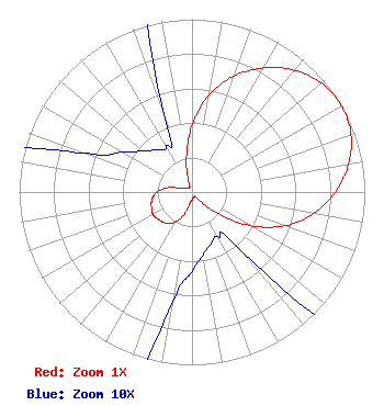 | ||||||||||||||||||
| Azimuth | Ratio | Azimuth | Ratio | Azimuth | Ratio | Azimuth | Ratio | ||||||||||||
| 0 | 0.388 | 10 | 0.570 | 20 | 0.715 | 30 | 0.829 | ||||||||||||
| 40 | 0.920 | 50 | 0.979 | 60 | 1.000 | 70 | 0.979 | ||||||||||||
| 80 | 0.920 | 90 | 0.829 | 100 | 0.715 | 110 | 0.570 | ||||||||||||
| 120 | 0.388 | 130 | 0.187 | 140 | 0.045 | 150 | 0.030 | ||||||||||||
| 160 | 0.032 | 170 | 0.037 | 180 | 0.046 | 190 | 0.065 | ||||||||||||
| 200 | 0.142 | 210 | 0.202 | 220 | 0.234 | 230 | 0.250 | ||||||||||||
| 240 | 0.260 | 250 | 0.250 | 260 | 0.234 | 270 | 0.202 | ||||||||||||
| 280 | 0.142 | 290 | 0.065 | 300 | 0.046 | 310 | 0.037 | ||||||||||||
| 320 | 0.032 | 330 | 0.030 | 340 | 0.045 | 350 | 0.187 | ||||||||||||
Structure Registration Number 1018642 Structure Type: TOWER Registered To: KOELZER, HARRY P DBA = ROSEBUD PROPERTIES Structure Address: 5831 Rosebud Ln Sacramento, CA County Name: Sacramento County ASR Issued: 04/24/1997 Date Built: 01/01/1991 Site Elevation: 32.3 m (106 ft.) Structure Height: 105.5 m (346 ft.) Height Overall: 106.3 m (349 ft.) Overall Height AMSL: 138.6 m (455 ft.) Paint & Light FAA Chapters: 1, 3, 11, 21 38-40-22.0 N 121-19-56.0 W (NAD 83) 38-40-22.3 N 121-19-52.2 W (Converted to NAD 27) |
9019 West Lane Stockton, CA 95210 | Date: 02/19/1998 Application Certifier YOUR CHRISTIAN COMPANION NETWORK, INC. Your Christian Companion Network, Inc. 9019 West Lane Stockton, CA 95210 Applicant | |||||||||||||||||