
FCCInfo.com
A Service of Cavell, Mertz & Associates, Inc.
(855) FCC-INFO
|
|
|
|
|
||||||||||||||||
|
|
W235AV Channel: 235D 94.9 MHz Tatnuck, Massachusetts Service: FX - A translator or application for a translator. Facility ID: 138657 Fac. Service: FX Programming Delivery Method: Unspecified Status: License Application Accepted: 07/25/2007 Application Granted: 10/05/2007 File Number: BLFT-20070725AAR License Expires: 00/00/0000 Prefix Type: This is a license for a translator Application Type: License To Cover FCC Website Links: LMS Facility Details This Application CDBS Application Other W235AV Applications Other W235AV Applications in CDBS Including Superseded Applications Mailing Address Correspondence for W235AV Correspondence related to application BLFT-20070725AAR Service Contour - Open Street Map or USGS Map (60 dBu) Service Contour - KML / Google Earth (60 dBu) Class: D, A Noncommercial educational operating with no more than 10W Site Location: 42-18-34.3 N 71-54-11.3 W (NAD 83) Site Location: 42-18-34.0 N 71-54-13.0 W (Converted to NAD 27) Effective Radiated Power: 0.23 kW Transmitter Output Power: 0.073 kW Antenna Center HAAT: 232.1 m Horiz.; 0 m Vert. Antenna Center AMSL: 474 m Horiz.; 472 m Vert. (1555 ft. Horiz. / 1549 ft. Vert.) Antenna Center HAG: 75 m Horiz.; 73 m Vert. (246 ft. Horiz. / 240 ft. Vert.) Site Elevation: 399 m. (1309 ft.) Height Overall*: 112 m (367 ft.) (* As Filed In This Application, may differ from ASR Data, Below.) Directional Antenna Antenna Make/Model: None Antenna ID: 16149 Polarization:
| ||||||||||||||||||
| Antenna Data for Antenna Id: 16149 W235AV FX File: BLFT-20070725AAR None - Service: FX Pattern and Field Values Include a 121° Clockwise Rotation | 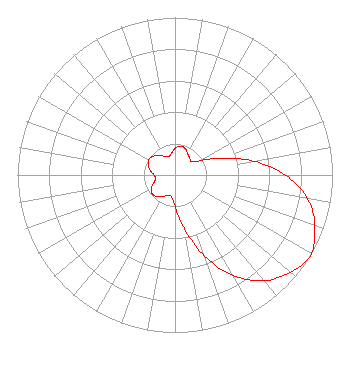 | ||||||||||||||||||
| Azimuth | Ratio | Azimuth | Ratio | Azimuth | Ratio | Azimuth | Ratio | ||||||||||||
| 1 | 0.171 | 11 | 0.187 | 21 | 0.181 | 31 | 0.157 | ||||||||||||
| 41 | 0.142 | 51 | 0.134 | 61 | 0.190 | 71 | 0.329 | ||||||||||||
| 81 | 0.528 | 91 | 0.718 | 101 | 0.866 | 111 | 0.952 | ||||||||||||
| 121 | 1.000 | 131 | 0.952 | 141 | 0.866 | 151 | 0.718 | ||||||||||||
| 161 | 0.528 | 171 | 0.329 | 181 | 0.190 | 191 | 0.134 | ||||||||||||
| 201 | 0.142 | 211 | 0.157 | 221 | 0.181 | 231 | 0.187 | ||||||||||||
| 241 | 0.171 | 251 | 0.140 | 261 | 0.123 | 271 | 0.135 | ||||||||||||
| 281 | 0.160 | 291 | 0.182 | 301 | 0.193 | 311 | 0.182 | ||||||||||||
| 321 | 0.160 | 331 | 0.135 | 341 | 0.123 | 351 | 0.140 | ||||||||||||
Structure Registration Number 1007888 Structure Type: TOWER Registered To: Vertical Bridge CC FM, LLC Structure Address: 96 Stereo Ln Off Asnebumskit Rd Paxton, MA County Name: Worcester County ASR Issued: 11/08/2018 Date Built: 11/11/1988 Site Elevation: 398.7 m (1308 ft.) Structure Height: 110.1 m (361 ft.) Height Overall: 111.6 m (366 ft.) Overall Height AMSL: 510.3 m (1674 ft.) FAA Determination: 02/16/1988 FAA Study #: 88-ANE-088-OE FAA Circular #: 70/7460-1G Paint & Light FAA Chapters: 3, 4, 5, 9 42-18-34.0 N 71-54-11.0 W (NAD 83) 42-18-33.7 N 71-54-12.7 W (Converted to NAD 27) |
7136 S. Yale Avenue Suite 501 Tulsa, OK 74136 Phone: 918-664-4581 | Date: 07/25/2007 Application Certifier AMFM RADIO LICENSES, LLC 2625 S. Memorial Drive Suite A Tulsa, OK 74129 Applicant LANCE NELMS 2625 S. Memorial Drive Suite A Tulsa, OK 74129 FCC ENGINEER MARISSA G. REPP Hogan & Hartson L.l.p. 555 - 13th Street, N.w. Washington, DC 20004-1109 | |||||||||||||||||