
FCCInfo.com
A Service of Cavell, Mertz & Associates, Inc.
(855) FCC-INFO
|
|
WRIQ from 12/22/2017 WRIQ from 08/18/2015 WRIQ from 09/26/1997 |
|
|
||||||||||||||||
|
|
WRIQ Channel: 209B 89.7 MHz Charles City, Virginia Service: FM - A full-service FM station or application. Facility ID: 82970 Fac. Service: FM Status: License Application Accepted: 09/20/2018 Application Granted: 02/14/2019 File Number: BLED-20180920AAB License Expires: 00/00/0000 Prefix Type: This is a license for a noncommercial educational FM station Application Type: Amendment FCC Website Links: LMS Facility Details This Application CDBS Application Other WRIQ Applications Other WRIQ Applications in CDBS Including Superseded Applications Mailing Address Correspondence for WRIQ Correspondence related to application BLED-20180920AAB Service Contour - Open Street Map or USGS Map (60 dBu) Service Contour - KML / Google Earth (60 dBu) Public Inspection Files Facility Type: NON-COMMERCIAL EDUC. FM Class: B, A Zone I or I-A station; with 25kW-50kW ERP and a class contour distance 39km-52km Site Location: 37-31-40.5 N 77-22-46.9 W (NAD 83) Site Location: 37-31-40.0 N 77-22-48.0 W (Converted to NAD 27) Effective Radiated Power: 27 kW Transmitter Output Power: 8.432 kW Antenna Center HAAT: 69.6 m (228 ft.) Antenna Center AMSL: 106.6 m (350 ft.) Antenna Center HAG: 70 m (230 ft.) Site Elevation: 36.6 m. (120 ft.) Height Overall*: 75 m (246 ft.) (* As Filed In This Application, may differ from ASR Data, Below.) Directional Antenna Antenna Make/Model: None Shively 6025-2-1/1, 2 bays, 1 wavelength spaced Antenna ID: 122166 Polarization: | ||||||||||||||||||
| Antenna Data for Antenna Id: 122166 WRIQ FM File: BLED-20180920AAB None - Shively 6025-2-1/1, 2 bays, 1 wavelength spaced Service: FM | 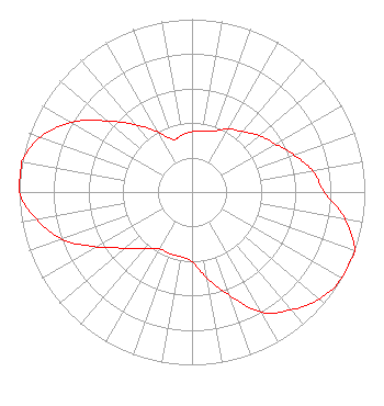 | ||||||||||||||||||
| Azimuth | Ratio | Azimuth | Ratio | Azimuth | Ratio | Azimuth | Ratio | ||||||||||||
| 0 | 0.350 | 10 | 0.358 | 20 | 0.375 | 30 | 0.421 | ||||||||||||
| 40 | 0.456 | 50 | 0.509 | 60 | 0.557 | 70 | 0.628 | ||||||||||||
| 80 | 0.708 | 90 | 0.765 | 100 | 0.900 | 110 | 1.000 | ||||||||||||
| 120 | 1.000 | 130 | 0.962 | 140 | 0.890 | 150 | 0.804 | ||||||||||||
| 160 | 0.639 | 170 | 0.507 | 180 | 0.403 | 190 | 0.380 | ||||||||||||
| 200 | 0.380 | 210 | 0.380 | 220 | 0.428 | 230 | 0.504 | ||||||||||||
| 240 | 0.635 | 250 | 0.799 | 260 | 0.911 | 270 | 1.000 | ||||||||||||
| 280 | 1.000 | 290 | 0.932 | 300 | 0.806 | 310 | 0.640 | ||||||||||||
| 320 | 0.509 | 330 | 0.404 | 340 | 0.323 | 350 | 0.335 | ||||||||||||
Structure Registration Number 1231421 [ASR Heights Differ from WRIQ Application] Structure Type: GTOWER Registered To: Virginia Tech Foundation, Inc WVTF Public Radio Structure Address: 2450 Inman Avenue Richmond, VA County Name: Henrico County ASR Issued: 02/25/2020 Date Built: 07/12/2019 Site Elevation: 36.6 m (120 ft.) Structure Height: 74.7 m (245 ft.) Height Overall: 75.6 m (248 ft.) Overall Height AMSL: 112.2 m (368 ft.) FAA Determination: 07/17/1973 FAA Study #: 73-EA-871-OE FAA Circular #: 70/7460-1 Paint & Light FAA Chapters: 1, 3, 11, 21 RED LIGHTS/PAINT 37-31-40.5 N 77-22-46.9 W (NAD 83) 37-31-40.0 N 77-22-48.0 W (Converted to NAD 27) |
3520 Kingsbury Lane Roanoke, VA 24014 Phone: 540-989-8900 Not-for-Profit | Date: 09/20/2018 Application Certifier EDUCATIONAL MEDIA FOUNDATION 5700 West Oaks Blvd Rocklin, CA 95765 Applicant STEPHEN WILDE 5700 West Oaks Blvd Rocklin, CA 95765 CONSULTING ENGINEER MARY O'CONNOR Wilkinson Barker Knauer, Llp | |||||||||||||||||