
FCCInfo.com
A Service of Cavell, Mertz & Associates, Inc.
(855) FCC-INFO
|
|
WAEZ from 07/31/2000 WAEZ from 09/27/1982 |
|  |
|
|||||||||||||||
|
|
WAEZ Channel: 235C0 94.9 MHz Greeneville, Tennessee Service: FM - A full-service FM station or application. Facility ID: 54601 Fac. Service: FM Status: License Application Accepted: 05/04/2001 Application Granted: 12/14/2005 File Number: BMLH-20010504AAT License Expires: 00/00/0000 Prefix Type: This is a modification of a license for a commecial FM station Application Type: Minor Amendment FCC Website Links: LMS Facility Details This Application CDBS Application Other WAEZ Applications Other WAEZ Applications in CDBS Including Superseded Applications Mailing Address Correspondence for WAEZ Correspondence related to application BMLH-20010504AAT Service Contour - Open Street Map or USGS Map (60 dBu) Service Contour - KML / Google Earth (60 dBu) Public Inspection Files History Cards for WAEZ Facility Type: FM STATION Class: C0, C0 Site Location: 36-04-34.4 N 82-41-27.5 W (NAD 83) Site Location: 36-04-34.0 N 82-41-28.0 W (Converted to NAD 27) Effective Radiated Power: 100 kW Horiz. ; 87 kW Vert. Transmitter Output Power: 31.1 kW Antenna Center HAAT: 332 m (1089 ft.) Antenna Center AMSL: 1042 m (3419 ft.) Antenna Center HAG: 49 m (161 ft.) Site Elevation: 994 m. (3261 ft.) Height Overall*: 61 m (200 ft.) (* As Filed In This Application, may differ from ASR Data, Below.) Directional Antenna Antenna Make/Model: DIELECTRIC DCRM4ESS.88, 4 section, 0.875 wavelength spaced Antenna ID: 13478 Polarization:
| ||||||||||||||||||
| Antenna Data for Antenna Id: 13478 WAEZ FM File: BMLH-20010504AAT DIELECTRIC - DCRM4ESS.88, 4 section, 0.875 wavelength spaced Service: FM | 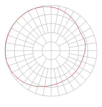 | ||||||||||||||||||
| Azimuth | Ratio | Azimuth | Ratio | Azimuth | Ratio | Azimuth | Ratio | ||||||||||||
| 0 | 0.956 | 10 | 0.929 | 20 | 0.894 | 30 | 0.855 | ||||||||||||
| 40 | 0.815 | 50 | 0.779 | 60 | 0.749 | 70 | 0.760 | ||||||||||||
| 80 | 0.760 | 90 | 0.740 | 100 | 0.720 | 110 | 0.706 | ||||||||||||
| 120 | 0.706 | 130 | 0.707 | 140 | 0.708 | 150 | 0.712 | ||||||||||||
| 160 | 0.721 | 170 | 0.739 | 180 | 0.764 | 190 | 0.798 | ||||||||||||
| 200 | 0.837 | 210 | 0.876 | 220 | 0.913 | 230 | 0.945 | ||||||||||||
| 240 | 0.968 | 250 | 0.984 | 260 | 1.000 | 270 | 1.000 | ||||||||||||
| 280 | 1.000 | 290 | 1.000 | 300 | 1.000 | 310 | 1.000 | ||||||||||||
| 320 | 1.000 | 330 | 1.000 | 340 | 0.989 | 350 | 0.976 | ||||||||||||
Structure Registration Number 1253826 [ASR Heights Differ from WAEZ Application] Structure Type: TOWER Registered To: Bristol Broadcasting Company, Inc. Structure Address: Greystone Mtn, 9 Miles Se Of Greenville Greenville, TN County Name: Greene County ASR Issued: 06/12/2006 Site Elevation: 975.4 m (3200 ft.) Structure Height: 186.9 m (613 ft.) Height Overall: 187.8 m (616 ft.) Overall Height AMSL: 1163.2 m (3816 ft.) FAA Determination: 02/27/2006 FAA Study #: 2005-ASO-5080-OE FAA Circular #: 70/7460-1K Paint & Light FAA Chapters: 3, 4, 5, 12 Removed expiration and final dates from determination. Scenario 2./jjs/case#635066 36-04-34.4 N 82-41-27.5 W (NAD 83) 36-04-34.0 N 82-41-28.0 W (Converted to NAD 27) |
P.o. Box 1389 Bristol, VA 24201 Phone: 540-669-8112 | Date: 05/04/2001 Application Certifier BRISTOL BROADCASTING CO., INC. 901 East Valley Drive P. O. Box 1389 Bristol, VA 24201 Applicant CHARLES A. LAWSON 901 East Valley Drive P.o. Box 1389 Bristol, VA 54601 DIRECTOR OF ENGINEERING COLETTE M. CAPRETZ, ESQ. Shaw Pittman Llp | |||||||||||||||||
| |||||||||||||||||||