
FCCInfo.com
A Service of Cavell, Mertz & Associates, Inc.
(855) FCC-INFO
|
|
W219CY from 09/21/1995 |
|
|
||||||||||||||||
|
|
W219CY Channel: 219D 91.7 MHz Irmo, South Carolina Service: FX - A translator or application for a translator. Facility ID: 76023 Fac. Service: FX Programming Delivery Method: Unspecified Status: License Application Accepted: 06/08/2018 Application Granted: 06/18/2018 File Number: BLFT-20180608AAT License Expires: 00/00/0000 Prefix Type: This is a license for a translator Application Type: License To Cover FCC Website Links: LMS Facility Details This Application CDBS Application Other W219CY Applications Other W219CY Applications in CDBS Including Superseded Applications Mailing Address Correspondence for W219CY Correspondence related to application BLFT-20180608AAT Service Contour - Open Street Map or USGS Map (60 dBu) Service Contour - KML / Google Earth (60 dBu) Class: D, A Noncommercial educational operating with no more than 10W Site Location: 34-07-06.9 N 80-56-12.7 W (NAD 83) Site Location: 34-07-06.4 N 80-56-13.4 W (Converted to NAD 27) Effective Radiated Power: 0 kW Horiz. ; 0.25 kW Vert. Transmitter Output Power: 0.226 kW Antenna Center HAAT: 0 m Antenna Center AMSL: 0 m Horiz.; 363 m Vert. Antenna Center HAG: 0 m Horiz.; 244 m Vert. Site Elevation: 119 m. (390 ft.) Height Overall*: 306 m (1004 ft.) (* As Filed In This Application, may differ from ASR Data, Below.) Directional Antenna Antenna Make/Model: None Antenna ID: 131726 Polarization:
| ||||||||||||||||||
| Antenna Data for Antenna Id: 131726 W219CY FX File: BLFT-20180608AAT None - Service: FX | 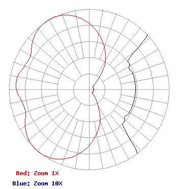 | ||||||||||||||||||
| Azimuth | Ratio | Azimuth | Ratio | Azimuth | Ratio | Azimuth | Ratio | ||||||||||||
| 0 | 0.823 | 10 | 0.699 | 20 | 0.557 | 30 | 0.408 | ||||||||||||
| 40 | 0.214 | 50 | 0.078 | 60 | 0.058 | 70 | 0.058 | ||||||||||||
| 80 | 0.058 | 90 | 0.058 | 100 | 0.058 | 110 | 0.058 | ||||||||||||
| 120 | 0.058 | 130 | 0.058 | 140 | 0.078 | 150 | 0.214 | ||||||||||||
| 160 | 0.408 | 170 | 0.557 | 180 | 0.699 | 190 | 0.823 | ||||||||||||
| 200 | 0.919 | 210 | 0.981 | 220 | 1.000 | 230 | 0.981 | ||||||||||||
| 240 | 0.919 | 250 | 0.842 | 260 | 0.854 | 270 | 0.906 | ||||||||||||
| 280 | 0.906 | 290 | 0.854 | 300 | 0.842 | 310 | 0.919 | ||||||||||||
| 320 | 0.981 | 330 | 1.000 | 340 | 0.981 | 350 | 0.919 | ||||||||||||
Structure Registration Number 1059176 Structure Type: TOWER Registered To: South Carolina Educational TV Commission Structure Address: Site Is 3.5 Mi N Of I-20 & U.s. 1/ .6 Mi E Mt. Pilgrim Church Columbia, SC County Name: Richland County ASR Issued: 08/24/2018 Date Built: 03/24/2005 Site Elevation: 119.4 m (392 ft.) Structure Height: 290.4 m (953 ft.) Height Overall: 305.9 m (1004 ft.) Overall Height AMSL: 425.3 m (1395 ft.) FAA Determination: 10/26/2004 FAA Study #: 2004-ASO-4292-OE FAA Circular #: 70/7460-1K Paint & Light FAA Chapters: 3, 4, 5, 12 PRIOR STUDY 2001-ASO-2905-OE 34-07-07.0 N 80-56-12.7 W (NAD 83) 34-07-06.5 N 80-56-13.4 W (Converted to NAD 27) |
5700 West Oaks Blvd. Rocklin, CA 95765 Phone: 916-251-1600 | Date: 06/08/2018 Application Certifier EDUCATIONAL MEDIA FOUNDATION 5700 West Oaks Blvd Rocklin, CA 95765 Applicant STEPHEN WILDE 5700 West Oaks Blvd Rocklin, CA 95765 CONSULTING ENGINEER MARY O'CONNOR Educational Media Foundation 1800 M Street, N.w. Suite 800n Washington, DC 20036 | |||||||||||||||||