
FCCInfo.com
A Service of Cavell, Mertz & Associates, Inc.
(855) FCC-INFO
|
|
WYBA from 06/16/2006 |
|  |
|
|||||||||||||||
|
|
WYBA Channel: 211B 90.1 MHz Coldwater, Michigan Service: FM - A full-service FM station or application. Facility ID: 121240 Fac. Service: FM Status: License Application Accepted: 06/02/2014 Application Granted: 06/30/2014 File Number: BMLED-20140602BAO License Expires: 00/00/0000 Prefix Type: This is a modification of license for a noncommercial educational FM station Application Type: Minor Modification FCC Website Links: LMS Facility Details This Application CDBS Application Other WYBA Applications Other WYBA Applications in CDBS Including Superseded Applications Mailing Address Correspondence for WYBA Correspondence related to application BMLED-20140602BAO Service Contour - Open Street Map or USGS Map (60 dBu) Service Contour - KML / Google Earth (60 dBu) Public Inspection Files Facility Type: NON-COMMERCIAL EDUC. FM Class: B, A Zone I or I-A station; with 25kW-50kW ERP and a class contour distance 39km-52km Site Location: 42-08-39.2 N 85-12-34.9 W (NAD 83) Site Location: 42-08-39.0 N 85-12-35.0 W (Converted to NAD 27) Effective Radiated Power: 32 kW Transmitter Output Power: 7.9 kW Antenna Center HAAT: 77 m (253 ft.) Antenna Center AMSL: 359 m (1178 ft.) Antenna Center HAG: 83 m (272 ft.) Calculated Site Elevation: 276 m. (906 ft.) Height Overall*: 91 m (299 ft.) (* As Filed In This Application, may differ from ASR Data, Below.) Directional Antenna Antenna Make/Model: Systems With Reliability Inc. FM10D/5-DA Antenna ID: 103347 Polarization:
| ||||||||||||||||||
| Antenna Data for Antenna Id: 103347 WYBA FM File: BMLED-20140602BAO Systems With Reliability Inc. - FM10D/5-DA Service: FM | 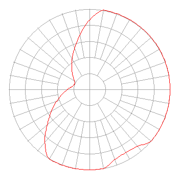 | ||||||||||||||||||
| Azimuth | Ratio | Azimuth | Ratio | Azimuth | Ratio | Azimuth | Ratio | ||||||||||||
| 0 | 0.862 | 10 | 1.000 | 20 | 1.000 | 30 | 1.000 | ||||||||||||
| 40 | 1.000 | 50 | 1.000 | 60 | 1.000 | 70 | 1.000 | ||||||||||||
| 80 | 1.000 | 90 | 1.000 | 100 | 1.000 | 110 | 1.000 | ||||||||||||
| 120 | 1.000 | 130 | 1.000 | 140 | 0.926 | 150 | 0.906 | ||||||||||||
| 160 | 0.926 | 170 | 1.000 | 180 | 1.000 | 190 | 1.000 | ||||||||||||
| 200 | 1.000 | 210 | 1.000 | 220 | 0.862 | 230 | 0.685 | ||||||||||||
| 240 | 0.544 | 250 | 0.432 | 260 | 0.343 | 270 | 0.273 | ||||||||||||
| 280 | 0.217 | 290 | 0.198 | 300 | 0.217 | 310 | 0.273 | ||||||||||||
| 320 | 0.343 | 330 | 0.432 | 340 | 0.544 | 350 | 0.685 | ||||||||||||
Structure Registration Number 1277038 [ASR Heights Differ from WYBA Application] Structure Type: GTOWER Registered To: Bible Broadcasting Network, Inc. Structure Address: 5013 Michigan Highway 66, 1.5 Mi S Of East Leroy East Leroy, MI County Name: Calhoun County ASR Issued: 04/30/2014 Date Built: 08/19/2011 Site Elevation: 275.5 m (904 ft.) Structure Height: 90.5 m (297 ft.) Height Overall: 91.4 m (300 ft.) Overall Height AMSL: 366.9 m (1204 ft.) FAA Determination: 04/29/2014 FAA Study #: 2014-AGL-3234-OE FAA Circular #: 70/7460-1K Paint & Light FAA Chapters: 3, 4, 5, 12 OM&L to remain the same as prior study = PAINT/RED LIGHTS 42-08-39.0 N 85-12-35.2 W (NAD 83) 42-08-38.8 N 85-12-35.3 W (Converted to NAD 27) |
11530 Carmel Commons Boulevard Charlotte, NC 28226 Phone: 704-523-5555 Not-for-Profit | Date: 06/02/2014 Application Certifier BIBLE BROADCASTING NETWORK, INC. 11530 Carmel Commons Blvd. Charlotte, NC 28226 Applicant JUSTIN W. ASHER Munn-reese, Inc. Po Box 220, 385 Airport Dr. Coldwater, MI 49036-0220 CONSULTING ENGINEER GARY S. SMITHWICK, ESQ. Smithwick & Belendiuk, P.c. | |||||||||||||||||