
FCCInfo.com
A Service of Cavell, Mertz & Associates, Inc.
(855) FCC-INFO
|
|
K252FD from 02/27/2004 |
|
|
||||||||||||||||
|
|
K252FD Channel: 252D 98.3 MHz Thomasville, Colorado Service: FX - A translator or application for a translator. Facility ID: 138067 Fac. Service: FX Programming Delivery Method: Unspecified Status: License Application Accepted: 05/07/2015 Application Granted: 06/08/2015 File Number: BLFT-20150507ABV License Expires: 00/00/0000 Prefix Type: This is a license for a translator Application Type: License To Cover FCC Website Links: LMS Facility Details This Application CDBS Application Other K252FD Applications Other K252FD Applications in CDBS Including Superseded Applications Mailing Address Correspondence for K252FD Correspondence related to application BLFT-20150507ABV Service Contour - Open Street Map or USGS Map (60 dBu) Service Contour - KML / Google Earth (60 dBu) Class: D, A Noncommercial educational operating with no more than 10W Site Location: 39-21-11.9 N 106-41-02.1 W (NAD 83) Site Location: 39-21-12.0 N 106-40-60.0 W (Converted to NAD 27) Effective Radiated Power: 0.02 kW Transmitter Output Power: 0.02 kW Antenna Center HAAT: -415.9 m Horiz.; 0 m Vert. Antenna Center AMSL: 2669 m (8757 ft.) Antenna Center HAG: 9 m (30 ft.) Site Elevation: 2660 m. (8727 ft.) Height Overall*: 18 m (59 ft.) (* As Filed In This Application, may differ from ASR Data, Below.) Directional Antenna Antenna Make/Model: None Antenna ID: 111627 Polarization:
| ||||||||||||||||||
| Antenna Data for Antenna Id: 111627 K252FD FX File: BLFT-20150507ABV None - Service: FX | 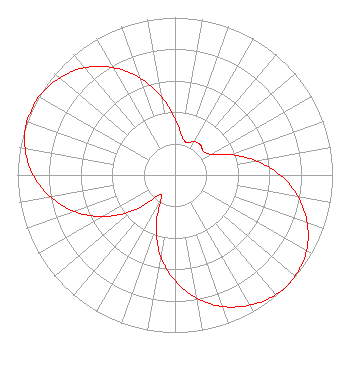 | ||||||||||||||||||
| Azimuth | Ratio | Azimuth | Ratio | Azimuth | Ratio | Azimuth | Ratio | ||||||||||||
| 0 | 0.357 | 10 | 0.252 | 20 | 0.218 | 30 | 0.246 | ||||||||||||
| 40 | 0.250 | 50 | 0.235 | 60 | 0.264 | 70 | 0.379 | ||||||||||||
| 80 | 0.519 | 90 | 0.667 | 100 | 0.793 | 110 | 0.893 | ||||||||||||
| 120 | 0.965 | 130 | 0.996 | 140 | 0.994 | 150 | 0.953 | ||||||||||||
| 160 | 0.889 | 170 | 0.793 | 180 | 0.671 | 190 | 0.524 | ||||||||||||
| 200 | 0.349 | 210 | 0.180 | 220 | 0.173 | 230 | 0.351 | ||||||||||||
| 240 | 0.526 | 250 | 0.679 | 260 | 0.801 | 270 | 0.901 | ||||||||||||
| 280 | 0.967 | 290 | 1.000 | 300 | 0.999 | 310 | 0.957 | ||||||||||||
| 320 | 0.891 | 330 | 0.787 | 340 | 0.658 | 350 | 0.507 | ||||||||||||
Structure Registration Number 1242303 Structure Type: TOWER Registered To: Pitkin County Translator Department Structure Address: Thomasville Communications Site Thomasville, CO County Name: Pitkin County ASR Issued: 12/30/2014 Date Built: 06/18/2004 Site Elevation: 2659.7 m (8726 ft.) Structure Height: 18.3 m (60 ft.) Height Overall: 18.3 m (60 ft.) Overall Height AMSL: 2678 m (8786 ft.) FAA Determination: 05/07/2002 FAA Study #: 02-ANM-0405-OE Paint & Light FAA Chapters: NONE 39-21-11.9 N 106-41-02.1 W (NAD 83) 39-21-12.0 N 106-40-60.0 W (Converted to NAD 27) |
530 E Main Street Garden Level Aspen, CO 81611 Phone: 970-920-5395 | Date: 05/07/2015 Application Certifier PITKIN COUNTY TRANSLATOR DEPARTMENT 530 E Main Street Garden Level Aspen, CO 81611 Applicant JON V BANKS 1015 Park West Drive Glenwood Springs, CO 81601 TECHNICAL CONSULTANT PITKIN COUNTY TRANSLATOR DEPARTMENT Pitkin County Translator Department 530 E Main Street Garden Level Aspen, CO 81611 | |||||||||||||||||