
FCCInfo.com
A Service of Cavell, Mertz & Associates, Inc.
(855) FCC-INFO
|
|
|
|
|
||||||||||||||||
|
|
K277DP Channel: 277D 103.3 MHz Little Rock, Arkansas Service: FX - A translator or application for a translator. Facility ID: 202855 Fac. Service: FX Programming Delivery Method: Unspecified Status: License Application Accepted: 02/08/2019 Application Granted: 02/15/2019 File Number: BLFT-20190208AAJ License Expires: 00/00/0000 Prefix Type: This is a license for a translator Application Type: License To Cover FCC Website Links: LMS Facility Details This Application CDBS Application Other K277DP Applications Other K277DP Applications in CDBS Including Superseded Applications Mailing Address Correspondence for K277DP Correspondence related to application BLFT-20190208AAJ Service Contour - Open Street Map or USGS Map (60 dBu) Service Contour - KML / Google Earth (60 dBu) Class: D, A Noncommercial educational operating with no more than 10W Site Location: 34-47-49.3 N 92-29-20.1 W (NAD 83) Site Location: 34-47-49.0 N 92-29-19.5 W (Converted to NAD 27) Effective Radiated Power: 0.25 kW Transmitter Output Power: 0.145 kW Antenna Center HAAT: 0 m Antenna Center AMSL: 554 m (1818 ft.) Antenna Center HAG: 274 m (899 ft.) Site Elevation: 280 m. (919 ft.) Height Overall*: 370 m (1214 ft.) (* As Filed In This Application, may differ from ASR Data, Below.) Directional Antenna Antenna Make/Model: None Antenna ID: 133626 Polarization:
| ||||||||||||||||||
| Antenna Data for Antenna Id: 133626 K277DP FX File: BLFT-20190208AAJ None - Service: FX | 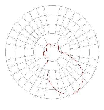 | ||||||||||||||||||
| Azimuth | Ratio | Azimuth | Ratio | Azimuth | Ratio | Azimuth | Ratio | ||||||||||||
| 0 | 0.135 | 10 | 0.123 | 20 | 0.140 | 30 | 0.171 | ||||||||||||
| 40 | 0.187 | 50 | 0.181 | 60 | 0.157 | 70 | 0.142 | ||||||||||||
| 80 | 0.134 | 90 | 0.190 | 100 | 0.329 | 110 | 0.528 | ||||||||||||
| 120 | 0.718 | 130 | 0.866 | 140 | 0.952 | 150 | 1.000 | ||||||||||||
| 160 | 0.952 | 170 | 0.866 | 180 | 0.718 | 190 | 0.528 | ||||||||||||
| 200 | 0.329 | 210 | 0.190 | 220 | 0.134 | 230 | 0.142 | ||||||||||||
| 240 | 0.157 | 250 | 0.181 | 260 | 0.187 | 270 | 0.171 | ||||||||||||
| 280 | 0.140 | 290 | 0.123 | 300 | 0.135 | 310 | 0.160 | ||||||||||||
| 320 | 0.182 | 330 | 0.193 | 340 | 0.182 | 350 | 0.160 | ||||||||||||
Structure Registration Number 1263739 [ASR Heights Differ from K277DP Application] Structure Type: GTOWER Registered To: KATV Licensee, LLC Structure Address: Shinall Mountain Antenna Farm Little Rock, AR County Name: Pulaski County ASR Issued: 02/22/2023 Date Built: 03/18/2009 Site Elevation: 278.9 m (915 ft.) Structure Height: 350.5 m (1150 ft.) Height Overall: 372.5 m (1222 ft.) Overall Height AMSL: 651.4 m (2137 ft.) FAA Determination: 11/10/2022 FAA Study #: 2022-ASW-17115-OE FAA Circular #: 70/7460-1M Paint & Light FAA Chapters: 4, 9, 15 PRIOR STUDY 2021-ASW-7632-OE 34-47-50.6 N 92-29-20.8 W (NAD 83) 34-47-50.3 N 92-29-20.2 W (Converted to NAD 27) |
4880 Santa Rosa Rd. Camarillo, CA 93012 Phone: 805-987-0400 | Date: 02/08/2019 Application Certifier SALEM COMMUNICATIONS HOLDING CORPORATION 4880 Santa Rosa Road Camarillo, CA 93012-0948 Applicant WILLIAM J. GETZ Carl T. Jones Corporation 7901 Yarnwood Court Springfield, VA 22153 CONSULTING ENGINEER KATHLEEN A. KIRBY Wiley Rein Llp 1776 K Street, Nw Washington, DC 20006 | |||||||||||||||||