
FCCInfo.com
A Service of Cavell, Mertz & Associates, Inc.
(855) FCC-INFO
|
|
|
|  |
|
|||||||||||||||
|
|
WUKY Channel: 217C1 91.3 MHz Lexington, Kentucky Service: FM - A full-service FM station or application. Facility ID: 4303 Fac. Service: FM Status: License Application Accepted: 11/15/2006 Application Granted: 11/21/2006 File Number: BLED-20061115AAL License Expires: 00/00/0000 Prefix Type: This is a license for a noncommercial educational FM station Application Type: License To Cover FCC Website Links: LMS Facility Details This Application CDBS Application Other WUKY Applications Other WUKY Applications in CDBS Including Superseded Applications Mailing Address Correspondence for WUKY Correspondence related to application BLED-20061115AAL Service Contour - Open Street Map or USGS Map (60 dBu) Service Contour - KML / Google Earth (60 dBu) Public Inspection Files History Cards for WUKY Facility Type: NON-COMMERCIAL EDUC. FM Class: C1, A Zone II station; with 50kW-100kW ERP and a class contour distance 52km-72km Site Location: 37-52-45.3 N 84-19-32.8 W (NAD 83) Site Location: 37-52-45.0 N 84-19-33.0 W (Converted to NAD 27) Effective Radiated Power: 100 kW Transmitter Output Power: 19.63 kW Antenna Center HAAT: 237.4 m (779 ft.) Antenna Center AMSL: 500.4 m (1642 ft.) Antenna Center HAG: 221.6 m (727 ft.) Site Elevation: 278.8 m. (915 ft.) Height Overall*: 258.3 m (847 ft.) (* As Filed In This Application, may differ from ASR Data, Below.) Directional Antenna Antenna Make/Model: Electronics Research Inc. MP-8AC-DA-HW Antenna ID: 70644 Polarization: | ||||||||||||||||||
| Antenna Data for Antenna Id: 70644 WUKY FM File: BLED-20061115AAL Electronics Research Inc. - MP-8AC-DA-HW Service: FM | 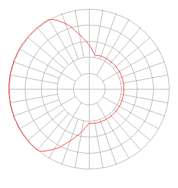 | ||||||||||||||||||
| Azimuth | Ratio | Azimuth | Ratio | Azimuth | Ratio | Azimuth | Ratio | ||||||||||||
| 0 | 0.549 | 10 | 0.436 | 20 | 0.436 | 30 | 0.436 | ||||||||||||
| 40 | 0.436 | 50 | 0.436 | 60 | 0.436 | 70 | 0.436 | ||||||||||||
| 80 | 0.436 | 90 | 0.436 | 100 | 0.436 | 110 | 0.436 | ||||||||||||
| 120 | 0.436 | 130 | 0.436 | 140 | 0.436 | 150 | 0.436 | ||||||||||||
| 160 | 0.436 | 170 | 0.436 | 180 | 0.436 | 190 | 0.549 | ||||||||||||
| 200 | 0.691 | 210 | 0.870 | 220 | 1.000 | 230 | 1.000 | ||||||||||||
| 240 | 1.000 | 250 | 1.000 | 260 | 1.000 | 270 | 1.000 | ||||||||||||
| 280 | 1.000 | 290 | 1.000 | 300 | 1.000 | 310 | 1.000 | ||||||||||||
| 320 | 1.000 | 330 | 1.000 | 340 | 0.870 | 350 | 0.691 | ||||||||||||
Structure Registration Number 1044040 Structure Type: TOWER Registered To: KENTUCKY AUTHORITY FOR EDUCATIONAL TELEVISION DBA = WKLE Structure Address: 1.6 Km Se Clays Ferry, KY County Name: Madison County ASR Issued: 08/10/1998 Date Built: 01/01/1967 Site Elevation: 278.8 m (915 ft.) Structure Height: 245.1 m (804 ft.) Height Overall: 258.3 m (847 ft.) Overall Height AMSL: 537.1 m (1762 ft.) FAA Determination: 07/29/1998 FAA Study #: 98-ASO-4076-OE Paint & Light FAA Chapters: 1, 3, 6, 15, 21 PREV. 95-ASO-1370-OE. 37-52-45.0 N 84-19-33.0 W (NAD 83) 37-52-44.7 N 84-19-33.2 W (Converted to NAD 27) |
2640 Spurr Road Lexington, KY 40511 Phone: 859-257-3226 Government Entity | Date: 11/15/2006 Application Certifier BOARD OF TRUSTEES, UNIVERSITY OF KENTUCKY 340 Mcvey Hall University Of Kentucky Lexington, KY 40506-0045 Applicant RICHARD H. MERTZ Cavell, Mertz & Davis, Inc. 7839 Ashton Avenue Manassas, VA 20109 CONSULTANT ERNEST T. SANCHEZ The Sanchez Law Firm | |||||||||||||||||
| |||||||||||||||||||