
FCCInfo.com
A Service of Cavell, Mertz & Associates, Inc.
(855) FCC-INFO
|
|
K221FQ from 07/13/2011 K221FQ from 03/23/2011 K221FQ from 08/03/2010 K221FQ from 06/24/2009 K221FQ from 01/13/1997 |
|
|
||||||||||||||||
|
|
K221FQ Channel: 221D 92.1 MHz Oklahoma City, Oklahoma Service: FX - A translator or application for a translator. Facility ID: 77231 Fac. Service: FX Programming Delivery Method: Unspecified Status: License Application Accepted: 05/08/2014 Application Granted: 10/23/2014 File Number: BLFT-20140508ABI License Expires: 00/00/0000 Prefix Type: This is a license for a translator Application Type: License To Cover FCC Website Links: LMS Facility Details This Application CDBS Application Other K221FQ Applications Other K221FQ Applications in CDBS Including Superseded Applications Mailing Address Correspondence for K221FQ Correspondence related to application BLFT-20140508ABI Service Contour - Open Street Map or USGS Map (60 dBu) Service Contour - KML / Google Earth (60 dBu) Class: D, A Noncommercial educational operating with no more than 10W Site Location: 35-33-37.2 N 97-29-07.1 W (NAD 83) Site Location: 35-33-37.0 N 97-29-06.0 W (Converted to NAD 27) Effective Radiated Power: 0.099 kW Transmitter Output Power: 0.117 kW Antenna Center HAAT: 0 m Antenna Center AMSL: 739 m (2425 ft.) Antenna Center HAG: 390 m (1280 ft.) Site Elevation: 349 m. (1145 ft.) Height Overall*: 489 m (1604 ft.) (* As Filed In This Application, may differ from ASR Data, Below.) Directional Antenna Antenna Make/Model: None Antenna ID: 117012 Polarization:
| ||||||||||||||||||
| Antenna Data for Antenna Id: 117012 K221FQ FX File: BLFT-20140508ABI None - Service: FX | 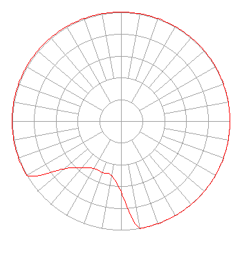 | ||||||||||||||||||
| Azimuth | Ratio | Azimuth | Ratio | Azimuth | Ratio | Azimuth | Ratio | ||||||||||||
| 0 | 1.000 | 10 | 1.000 | 20 | 1.000 | 30 | 1.000 | ||||||||||||
| 40 | 1.000 | 50 | 1.000 | 60 | 1.000 | 70 | 1.000 | ||||||||||||
| 80 | 1.000 | 90 | 1.000 | 100 | 1.000 | 110 | 1.000 | ||||||||||||
| 120 | 1.000 | 130 | 1.000 | 140 | 1.000 | 150 | 1.000 | ||||||||||||
| 160 | 1.000 | 170 | 1.000 | 180 | 0.648 | 190 | 0.508 | ||||||||||||
| 200 | 0.501 | 210 | 0.501 | 220 | 0.557 | 230 | 0.682 | ||||||||||||
| 240 | 1.000 | 250 | 1.000 | 260 | 1.000 | 270 | 1.000 | ||||||||||||
| 280 | 1.000 | 290 | 1.000 | 300 | 1.000 | 310 | 1.000 | ||||||||||||
| 320 | 1.000 | 330 | 1.000 | 340 | 1.000 | 350 | 1.000 | ||||||||||||
Structure Registration Number 1253490 Structure Type: GTOWER Registered To: American Towers LLC Structure Address: 1501 Ne 85th St Oklahoma City, OK County Name: Oklahoma County ASR Issued: 03/08/2017 Date Built: 06/21/2007 Site Elevation: 349 m (1145 ft.) Structure Height: 489 m (1604 ft.) Height Overall: 489 m (1604 ft.) Overall Height AMSL: 838 m (2749 ft.) FAA Determination: 03/02/2017 FAA Study #: 2015-ASW-1665-OE Paint & Light FAA Chapters: B, F, H, 3, 10, 19, 21, 23 PRIOR STUDY 2007-ASW-5048-OE 35-33-36.9 N 97-29-07.6 W (NAD 83) 35-33-36.7 N 97-29-06.5 W (Converted to NAD 27) |
1528 N.e. 23rd Street Oklahoma City, OK 73111 Phone: 405-424-4695 | Date: 05/08/2014 Application Certifier PERRY BROADCASTING COMPANY, INC. 1528 Ne 23rd Street Oklahoma City, OK 73111 Applicant JOEL T. SAXBERG 2322 S. Second Ave. Arcadia, CA 91006-5203 BROADCAST ENGINEERING CONSULTANT H. EDWARD DEBEE Debee Gilchrist 100 N. Broadway Avenue Suite 1500 Oklahoma City, OK 73102 | |||||||||||||||||