
FCCInfo.com
A Service of Cavell, Mertz & Associates, Inc.
(855) FCC-INFO
|
|
|
|
|
||||||||||||||||
|
|
WNJZ Channel: 212A 90.3 MHz Cape May Court House, New Jersey Service: FM - A full-service FM station or application. Facility ID: 48464 Fac. Service: FM Status: License Application Accepted: 08/03/1999 Application Granted: 01/02/2002 File Number: BLED-19990803KB License Expires: 00/00/0000 Prefix Type: This is a license for a noncommercial educational FM station Application Type: License To Cover FCC Website Links: LMS Facility Details This Application CDBS Application Other WNJZ Applications Other WNJZ Applications in CDBS Including Superseded Applications Mailing Address Correspondence for WNJZ Correspondence related to application BLED-19990803KB Service Contour - Open Street Map or USGS Map (60 dBu) Service Contour - KML / Google Earth (60 dBu) Public Inspection Files Facility Type: NON-COMMERCIAL EDUC. FM Class: A, A Zone I; I-A; or II station; with 0.1kW-6kW ERP and a class contour distance <=28km Site Location: 39-06-18.4 N 74-48-04.6 W (NAD 83) Site Location: 39-06-18.0 N 74-48-06.0 W (Converted to NAD 27) Effective Radiated Power: 6 kW Transmitter Output Power: 1.4 kW Antenna Center HAAT: 72 m (236 ft.) Antenna Center AMSL: 72 m (236 ft.) Antenna Center HAG: 69 m (226 ft.) Site Elevation: 3 m. (10 ft.) Height Overall*: 82 m (269 ft.) (* As Filed In This Application, may differ from ASR Data, Below.) Directional Antenna Antenna Make/Model: Systems With Reliability Inc. FM3/3 DA, 3 Section Antenna ID: 16055 Polarization: | ||||||||||||||||||
| Antenna Data for Antenna Id: 16055 WNJZ FM File: BLED-19990803KB Systems With Reliability Inc. - FM3/3 DA, 3 Section Service: FM | 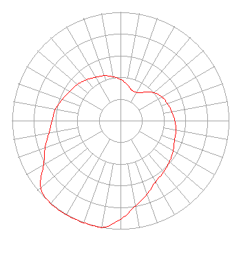 | ||||||||||||||||||
| Azimuth | Ratio | Azimuth | Ratio | Azimuth | Ratio | Azimuth | Ratio | ||||||||||||
| 0 | 0.380 | 10 | 0.340 | 20 | 0.300 | 30 | 0.300 | ||||||||||||
| 40 | 0.340 | 50 | 0.400 | 60 | 0.440 | 70 | 0.460 | ||||||||||||
| 80 | 0.480 | 90 | 0.500 | 100 | 0.520 | 110 | 0.530 | ||||||||||||
| 120 | 0.560 | 130 | 0.590 | 140 | 0.620 | 150 | 0.650 | ||||||||||||
| 160 | 0.720 | 170 | 0.800 | 180 | 0.910 | 190 | 1.000 | ||||||||||||
| 200 | 1.000 | 210 | 1.000 | 220 | 1.000 | 230 | 0.960 | ||||||||||||
| 240 | 0.820 | 250 | 0.740 | 260 | 0.670 | 270 | 0.630 | ||||||||||||
| 280 | 0.610 | 290 | 0.570 | 300 | 0.540 | 310 | 0.520 | ||||||||||||
| 320 | 0.490 | 330 | 0.460 | 340 | 0.440 | 350 | 0.410 | ||||||||||||
Structure Registration Number 1046071 [ASR Heights Differ from WNJZ Application] Structure Type: LTOWER Registered To: Atlantic Coast Communications LLC Structure Address: 916 Route 9 North Swainton, NJ County Name: Cape May County ASR Issued: 09/14/2021 Date Built: 07/30/1997 Site Elevation: 5.2 m (17 ft.) Structure Height: 76.5 m (251 ft.) Height Overall: 82.3 m (270 ft.) Overall Height AMSL: 87.5 m (287 ft.) FAA Determination: 09/13/2021 FAA Study #: 2021-AEA-7418-OE FAA Circular #: 70/7460-1K Paint & Light FAA Chapters: 4, 6, 12 OM&L to remain the same as prior study = 24-HR MED-STROBES 39-06-19.1 N 74-48-02.4 W (NAD 83) 39-06-18.7 N 74-48-03.8 W (Converted to NAD 27) |
150 North 6th Street Philadelphia, PA 19106 Phone: 215-351-3302 | Date: 08/03/1999 Application Certifier NEW JERSEY PUBLIC BRD/CAST AUTHORITY New Jersey Public Broadcasting Authority Po Box 777 Trenton, NJ 08625-0777 Applicant | |||||||||||||||||
| |||||||||||||||||||