
FCCInfo.com
A Service of Cavell, Mertz & Associates, Inc.
(855) FCC-INFO
|
|
WOTL from 04/11/1985 |
|  |
|
|||||||||||||||
|
|
WOTL Channel: 212A 90.3 MHz Toledo, Ohio Service: FM - A full-service FM station or application. Facility ID: 20678 Fac. Service: FM Status: License Application Accepted: 05/30/2013 Application Granted: 06/27/2013 File Number: BMLED-20130530AMK License Expires: 00/00/0000 Prefix Type: This is a modification of license for a noncommercial educational FM station Application Type: Minor Modification FCC Website Links: LMS Facility Details This Application CDBS Application Other WOTL Applications Other WOTL Applications in CDBS Including Superseded Applications Mailing Address Correspondence for WOTL Correspondence related to application BMLED-20130530AMK Service Contour - Open Street Map or USGS Map (60 dBu) Service Contour - KML / Google Earth (60 dBu) Public Inspection Files Facility Type: NON-COMMERCIAL EDUC. FM Class: A, A Zone I; I-A; or II station; with 0.1kW-6kW ERP and a class contour distance <=28km Site Location: 41-38-48.2 N 83-36-21.8 W (NAD 83) Site Location: 41-38-48.0 N 83-36-22.0 W (Converted to NAD 27) Effective Radiated Power: 0.7 kW Transmitter Output Power: 0.94 kW Antenna Center HAAT: 115 m (377 ft.) Antenna Center AMSL: 299 m (981 ft.) Antenna Center HAG: 111 m (364 ft.) Calculated Site Elevation: 188 m. (617 ft.) Height Overall*: 132 m (433 ft.) (* As Filed In This Application, may differ from ASR Data, Below.) Directional Antenna Antenna Make/Model: DIELECTRIC DCR-G1 Antenna ID: 13820 Polarization:
| ||||||||||||||||||
| Antenna Data for Antenna Id: 13820 WOTL FM File: BMLED-20130530AMK DIELECTRIC - DCR-G1 Service: FM | 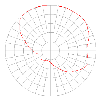 | ||||||||||||||||||
| Azimuth | Ratio | Azimuth | Ratio | Azimuth | Ratio | Azimuth | Ratio | ||||||||||||
| 0 | 0.980 | 10 | 0.990 | 20 | 1.000 | 30 | 0.990 | ||||||||||||
| 40 | 1.000 | 45 | 1.000 | 50 | 0.990 | 60 | 0.950 | ||||||||||||
| 70 | 0.900 | 80 | 0.830 | 90 | 0.800 | 100 | 0.830 | ||||||||||||
| 110 | 0.870 | 120 | 0.800 | 130 | 0.700 | 135 | 0.660 | ||||||||||||
| 140 | 0.610 | 150 | 0.490 | 160 | 0.390 | 170 | 0.320 | ||||||||||||
| 180 | 0.260 | 190 | 0.230 | 200 | 0.230 | 210 | 0.250 | ||||||||||||
| 220 | 0.270 | 225 | 0.280 | 230 | 0.270 | 240 | 0.240 | ||||||||||||
| 245 | 0.240 | 250 | 0.260 | 260 | 0.320 | 270 | 0.400 | ||||||||||||
| 280 | 0.490 | 290 | 0.600 | 300 | 0.760 | 310 | 0.880 | ||||||||||||
| 315 | 0.950 | 320 | 0.980 | 330 | 1.000 | 340 | 1.000 | ||||||||||||
| 350 | 1.000 | ||||||||||||||||||
Structure Registration Number 1054371 [ASR Heights Differ from WOTL Application] Structure Type: GTOWER Registered To: American Towers LLC Structure Address: Ne Of Westwood Ave. & Nebraska Ave. (westwood 1 Of 2 #50923) Toledo, OH County Name: Lucas County ASR Issued: 05/16/2013 Date Built: 05/10/2002 Site Elevation: 186.8 m (613 ft.) Structure Height: 132.6 m (435 ft.) Height Overall: 134.2 m (440 ft.) Overall Height AMSL: 321 m (1053 ft.) FAA Determination: 04/29/2013 FAA Study #: 2013-AGL-3740-OE FAA Circular #: 70/7460-1K Paint & Light FAA Chapters: 4, 8, 12 OM&L to remain the same as prior study = A MED-DUAL SYSTEM 41-38-48.7 N 83-36-17.7 W (NAD 83) 41-38-48.5 N 83-36-17.9 W (Converted to NAD 27) |
112 North Elm Street Shenandoah, IA 51601 Phone: 712-246-5151 Not-for-Profit | Date: 05/30/2013 Application Certifier FAMILY STATIONS, INC. Harvest Broadcasting Assn. D/b/a Harvest Translators, Inc. 4135 Northgate Boulevard Suite 1 Sacramento, CA 95834 Applicant LINDA ADAMS 4135 Northgate Boulevard Ste. 1 Sacremento, CA 95834 ENGINEER MICHELLE A. MCCLURE, ESQ. Fletcher, Heald & Hildreth, P.l.c. | |||||||||||||||||