
FCCInfo.com
A Service of Cavell, Mertz & Associates, Inc.
(855) FCC-INFO
|
|
KMUE from 03/17/1995 |
|  |
|
|||||||||||||||
|
|
KMUE Channel: 201C1 88.1 MHz Eureka, California Service: FM - A full-service FM station or application. Facility ID: 55429 Fac. Service: FM Analog & Digital Status: License Application Accepted: 03/21/2012 Application Granted: 04/16/2012 File Number: BLED-20120321ADK License Expires: 00/00/0000 Prefix Type: This is a license for a noncommercial educational FM station Application Type: License To Cover FCC Website Links: LMS Facility Details This Application CDBS Application Other KMUE Applications Other KMUE Applications in CDBS Including Superseded Applications Mailing Address Correspondence for KMUE Correspondence related to application BLED-20120321ADK Service Contour - Open Street Map or USGS Map (60 dBu) Service Contour - KML / Google Earth (60 dBu) Public Inspection Files Facility Type: NON-COMMERCIAL EDUC. FM Class: C1, A Zone II station; with 50kW-100kW ERP and a class contour distance 52km-72km Site Location: 40-43-38.5 N 123-58-21.2 W (NAD 83) Site Location: 40-43-39.0 N 123-58-17.0 W (Converted to NAD 27) Effective Radiated Power: 10 kW Transmitter Output Power: 1.9 kW Antenna Center HAAT: 494 m (1621 ft.) Antenna Center AMSL: 882 m (2894 ft.) Antenna Center HAG: 74 m (243 ft.) Calculated Site Elevation: 808 m. (2651 ft.) Height Overall*: 134 m (440 ft.) (* As Filed In This Application, may differ from ASR Data, Below.) Directional Antenna Antenna Make/Model: Shivley 6810-6R-DA Antenna ID: 100932 Polarization:
| ||||||||||||||||||
| Antenna Data for Antenna Id: 100932 KMUE FM File: BLED-20120321ADK Shivley - 6810-6R-DA Service: FM | 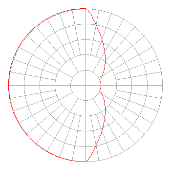 | ||||||||||||||||||
| Azimuth | Ratio | Azimuth | Ratio | Azimuth | Ratio | Azimuth | Ratio | ||||||||||||
| 0 | 1.000 | 10 | 0.794 | 20 | 0.631 | 30 | 0.501 | ||||||||||||
| 40 | 0.398 | 50 | 0.316 | 60 | 0.251 | 70 | 0.200 | ||||||||||||
| 80 | 0.200 | 90 | 0.200 | 100 | 0.200 | 110 | 0.200 | ||||||||||||
| 120 | 0.251 | 130 | 0.316 | 140 | 0.398 | 150 | 0.501 | ||||||||||||
| 160 | 0.631 | 170 | 0.794 | 180 | 1.000 | 190 | 1.000 | ||||||||||||
| 200 | 1.000 | 210 | 1.000 | 220 | 1.000 | 230 | 1.000 | ||||||||||||
| 240 | 1.000 | 250 | 1.000 | 260 | 1.000 | 270 | 1.000 | ||||||||||||
| 280 | 1.000 | 290 | 1.000 | 300 | 1.000 | 310 | 1.000 | ||||||||||||
| 320 | 1.000 | 330 | 1.000 | 340 | 1.000 | 350 | 1.000 | ||||||||||||
Structure Registration Number 1224088 [ASR Heights Differ from KMUE Application] Structure Type: GTOWER Registered To: Redwood Empire Public Television Inc Structure Address: 1603 Barry Road Kneeland, CA County Name: Humboldt County ASR Issued: 12/29/2016 Date Built: 10/23/2015 Site Elevation: 805.3 m (2642 ft.) Structure Height: 121.9 m (400 ft.) Height Overall: 135.3 m (444 ft.) Overall Height AMSL: 940.6 m (3086 ft.) FAA Determination: 12/21/2016 FAA Study #: 2016-AWP-12398-OE FAA Circular #: 70/7460-1L Paint & Light FAA Chapters: 4, 8, 12 PRIOR STUDY 2015-AWP-9887-OE 40-43-41.9 N 123-58-21.5 W (NAD 83) 40-43-42.4 N 123-58-17.3 W (Converted to NAD 27) |
P.o. Box 135 Redway, CA 95560 | Date: 03/21/2012 Application Certifier REDWOOD COMMUNITY RADIO P.o. Box 135 Redway, CA 95560 Applicant GRAY FRIERSON HAERTIG 820 North River Street Suite 108 Portland, OR 97227 ENGINEERING COUNSEL JOHN CRIGLER Garvey Schubert Barer | |||||||||||||||||