
FCCInfo.com
A Service of Cavell, Mertz & Associates, Inc.
(855) FCC-INFO
|
|
K271BL from 07/30/1986 |
|
|
||||||||||||||||
|
|
K271BL Channel: 271D 102.1 MHz Roseburg, Oregon Service: FX - A translator or application for a translator. Facility ID: 57282 Fac. Service: FX Programming Delivery Method: Unspecified Status: License Application Accepted: 07/27/2009 Application Granted: 09/14/2009 File Number: BLFT-20090727ADR License Expires: 00/00/0000 Prefix Type: This is a license for a translator Application Type: License To Cover FCC Website Links: LMS Facility Details This Application CDBS Application Other K271BL Applications Other K271BL Applications in CDBS Including Superseded Applications Mailing Address Correspondence for K271BL Correspondence related to application BLFT-20090727ADR Service Contour - Open Street Map or USGS Map (60 dBu) Service Contour - KML / Google Earth (60 dBu) Class: D, A Noncommercial educational operating with no more than 10W Site Location: 43-12-07.4 N 123-22-57.3 W (NAD 83) Site Location: 43-12-08.0 N 123-22-53.0 W (Converted to NAD 27) Effective Radiated Power: 0.062 kW Horiz. ; 0 kW Vert. Transmitter Output Power: 0.01 kW Antenna Center HAAT: 152 m Horiz.; 0 m Vert. Antenna Center AMSL: 425 m Horiz.; 0 m Vert. Antenna Center HAG: 17 m Horiz.; 0 m Vert. Site Elevation: 408 m. (1339 ft.) Height Overall*: 30 m (98 ft.) (* As Filed In This Application, may differ from ASR Data, Below.) Directional Antenna Antenna Make/Model: None Antenna ID: 91427 Polarization:
| ||||||||||||||||||
| Antenna Data for Antenna Id: 91427 K271BL FX File: BLFT-20090727ADR None - Service: FX | 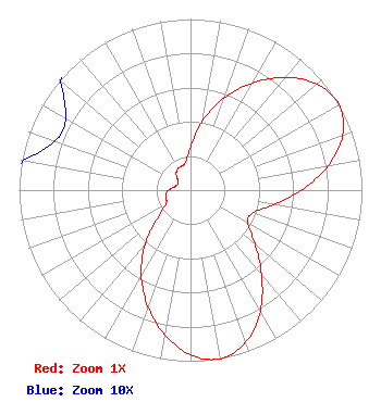 | ||||||||||||||||||
| Azimuth | Ratio | Azimuth | Ratio | Azimuth | Ratio | Azimuth | Ratio | ||||||||||||
| 0 | 0.248 | 10 | 0.413 | 20 | 0.574 | 30 | 0.724 | ||||||||||||
| 40 | 0.859 | 50 | 0.964 | 60 | 1.000 | 70 | 0.945 | ||||||||||||
| 80 | 0.814 | 90 | 0.645 | 100 | 0.490 | 110 | 0.386 | ||||||||||||
| 120 | 0.386 | 130 | 0.490 | 140 | 0.645 | 150 | 0.814 | ||||||||||||
| 160 | 0.945 | 170 | 1.000 | 180 | 0.964 | 190 | 0.859 | ||||||||||||
| 200 | 0.724 | 210 | 0.574 | 220 | 0.413 | 230 | 0.248 | ||||||||||||
| 240 | 0.168 | 250 | 0.149 | 260 | 0.146 | 270 | 0.129 | ||||||||||||
| 280 | 0.099 | 290 | 0.084 | 300 | 0.084 | 310 | 0.099 | ||||||||||||
| 320 | 0.129 | 330 | 0.146 | 340 | 0.149 | 350 | 0.168 | ||||||||||||
Structure Registration Number 1266947 Structure Type: TOWER Registered To: JATCOM Corp. Structure Address: Nebo Ridge 2.8 Km Sw Center Of Roseburg Or Roseburg, OR County Name: Douglas County ASR Issued: 01/23/2009 Date Built: 01/01/1991 Site Elevation: 408.1 m (1339 ft.) Structure Height: 30.4 m (100 ft.) Height Overall: 30.4 m (100 ft.) Overall Height AMSL: 438.5 m (1439 ft.) FAA Determination: 01/22/2009 FAA Study #: 2008-ANM-3300-OE Paint & Light FAA Chapters: NONE PRIOR STUDY 1996-ANM-1007-OE 43-12-07.8 N 123-22-57.4 W (NAD 83) 43-12-08.4 N 123-22-53.1 W (Converted to NAD 27) |
1303 Jewel Drive Roseburg, OR 97471 Phone: 541-672-5761 | Date: 07/27/2009 Application Certifier RAIDER COMMUNICATIONS, INC. 1303 Jewel Drive Roseburg, OR 97471 Applicant SETH B. THOMPSON 1303 Jewel Drive Roseburg, OR 97471 LICENSEE J. DOMINIC MONAHAN Luvaas Cobb 777 High Street Suite 300 Eugene, OR 97401-2787 | |||||||||||||||||