
FCCInfo.com
A Service of Cavell, Mertz & Associates, Inc.
(855) FCC-INFO
|
|
WLZL from 12/01/2011 |
|  |
|
|||||||||||||||
|
|
WLZL Channel: 300B 107.9 MHz College Park, Maryland Service: FM - A full-service FM station or application. Facility ID: 20983 Fac. Service: FM Analog & Digital Status: License Application Accepted: 09/14/2017 Application Granted: 10/24/2017 File Number: BMLH-20170914AAQ License Expires: 00/00/0000 Prefix Type: This is a modification of a license for a commecial FM station Application Type: Minor Modification FCC Website Links: LMS Facility Details This Application CDBS Application Other WLZL Applications Other WLZL Applications in CDBS Including Superseded Applications Mailing Address Correspondence for WLZL Correspondence related to application BMLH-20170914AAQ Service Contour - Open Street Map or USGS Map (54 dBu) Service Contour - KML / Google Earth (54 dBu) Public Inspection Files History Cards for WLZL Facility Type: FM STATION Class: B, A Zone I or I-A station; with 25kW-50kW ERP and a class contour distance 39km-52km Site Location: 38-59-46.0 N 76-39-23.9 W (NAD 83) Site Location: 38-59-45.6 N 76-39-25.0 W (Converted to NAD 27) Effective Radiated Power: 49 kW Transmitter Output Power: 14.72 kW Antenna Center HAAT: 151.1 m (496 ft.) Antenna Center AMSL: 180.4 m (592 ft.) Antenna Center HAG: 142.4 m (467 ft.) Site Elevation: 38 m. (125 ft.) Height Overall*: 152 m (499 ft.) (* As Filed In This Application, may differ from ASR Data, Below.) Directional Antenna Antenna Make/Model: Electronics Research Inc. 1183-6CP-COG-DA Antenna ID: 116791 Polarization: | ||||||||||||||||||
| Antenna Data for Antenna Id: 116791 WLZL FM File: BMLH-20170914AAQ Electronics Research Inc. - 1183-6CP-COG-DA Service: FM | 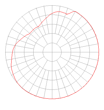 | ||||||||||||||||||
| Azimuth | Ratio | Azimuth | Ratio | Azimuth | Ratio | Azimuth | Ratio | ||||||||||||
| 0 | 0.824 | 10 | 0.875 | 20 | 0.875 | 22 | 0.875 | ||||||||||||
| 30 | 1.000 | 40 | 1.000 | 50 | 1.000 | 60 | 1.000 | ||||||||||||
| 70 | 1.000 | 80 | 1.000 | 90 | 1.000 | 100 | 1.000 | ||||||||||||
| 110 | 1.000 | 120 | 1.000 | 130 | 1.000 | 140 | 1.000 | ||||||||||||
| 150 | 1.000 | 160 | 1.000 | 170 | 1.000 | 180 | 1.000 | ||||||||||||
| 190 | 1.000 | 200 | 1.000 | 210 | 1.000 | 220 | 1.000 | ||||||||||||
| 230 | 0.986 | 240 | 0.956 | 250 | 0.925 | 260 | 0.875 | ||||||||||||
| 270 | 0.844 | 280 | 0.804 | 290 | 0.733 | 300 | 0.672 | ||||||||||||
| 310 | 0.621 | 320 | 0.621 | 330 | 0.621 | 333 | 0.621 | ||||||||||||
| 340 | 0.662 | 350 | 0.733 | ||||||||||||||||
Structure Registration Number 1036204 Structure Type: GTOWER Registered To: K2 Towers III, LLC Structure Address: 1702 Justin Dr Gambrills, MD County Name: Anne Arundel County ASR Issued: 03/06/2023 Date Built: 01/01/1989 Site Elevation: 38.1 m (125 ft.) Structure Height: 124 m (407 ft.) Height Overall: 152.1 m (499 ft.) Overall Height AMSL: 190.2 m (624 ft.) FAA Determination: 09/05/2017 FAA Study #: 2017-AEA-5164-OE FAA Circular #: 70/7460-1G Paint & Light FAA Chapters: 3, 4, 5, 9 OM&L to remain the same as prior study = PAINT/RED LIGHTS 38-59-46.0 N 76-39-23.9 W (NAD 83) 38-59-45.6 N 76-39-25.0 W (Converted to NAD 27) |
2400 Market Street 4th Floor Philadelphia, PA 19103 Phone: 610-660-5610 Limited Liability Company | Date: 09/14/2017 Application Certifier CBS RADIO ANNAPOLIS LLC 1725 Desales Street, Nw Suite 501 Washington, DC 20036 Applicant DANIEL G. RYSON Cbs 1725 Desales St. Nw, Suite 501 Washington, DC 20036-4426 EMPLOYEE OF PARENT CORPORATION LINDA D. FELDMANN Lerman Senter Pllc | |||||||||||||||||