
FCCInfo.com
A Service of Cavell, Mertz & Associates, Inc.
(855) FCC-INFO
|
|
|
|
|
||||||||||||||||
|
|
KTBJ Channel: 207B 89.3 MHz Festus, Missouri Service: FM - A full-service FM station or application. Facility ID: 76989 Fac. Service: FM Status: License Application Accepted: 07/23/2002 Application Granted: 08/29/2002 File Number: BLED-20020723AAA License Expires: 00/00/0000 Prefix Type: This is a license for a noncommercial educational FM station Application Type: License To Cover FCC Website Links: LMS Facility Details This Application CDBS Application Other KTBJ Applications Other KTBJ Applications in CDBS Including Superseded Applications Mailing Address Correspondence for KTBJ Correspondence related to application BLED-20020723AAA Service Contour - Open Street Map or USGS Map (60 dBu) Service Contour - KML / Google Earth (60 dBu) Public Inspection Files Facility Type: NON-COMMERCIAL EDUC. FM Class: B, A Zone I or I-A station; with 25kW-50kW ERP and a class contour distance 39km-52km Site Location: 38-09-16.2 N 90-02-07.4 W (NAD 83) Site Location: 38-09-16.0 N 90-02-07.0 W (Converted to NAD 27) Effective Radiated Power: 25 kW Transmitter Output Power: 4 kW Antenna Center HAAT: 113 m (371 ft.) Antenna Center AMSL: 258 m (846 ft.) Antenna Center HAG: 124 m (407 ft.) Site Elevation: 134 m. (440 ft.) Height Overall*: 137 m (449 ft.) (* As Filed In This Application, may differ from ASR Data, Below.) Directional Antenna Antenna Make/Model: Electronics Research Inc. 1092-6CP-DA Antenna ID: 34539 Polarization:
| ||||||||||||||||||
| Antenna Data for Antenna Id: 34539 KTBJ FM File: BLED-20020723AAA Electronics Research Inc. - 1092-6CP-DA Service: FM | 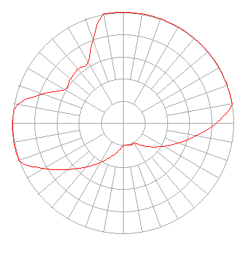 | ||||||||||||||||||
| Azimuth | Ratio | Azimuth | Ratio | Azimuth | Ratio | Azimuth | Ratio | ||||||||||||
| 0 | 1.000 | 10 | 1.000 | 20 | 1.000 | 30 | 1.000 | ||||||||||||
| 40 | 1.000 | 50 | 1.000 | 60 | 1.000 | 70 | 1.000 | ||||||||||||
| 80 | 1.000 | 90 | 0.843 | 100 | 0.670 | 110 | 0.532 | ||||||||||||
| 120 | 0.423 | 130 | 0.336 | 140 | 0.267 | 150 | 0.212 | ||||||||||||
| 160 | 0.210 | 170 | 0.202 | 180 | 0.207 | 190 | 0.261 | ||||||||||||
| 200 | 0.328 | 210 | 0.413 | 220 | 0.520 | 230 | 0.655 | ||||||||||||
| 240 | 0.824 | 250 | 1.000 | 260 | 1.000 | 270 | 1.000 | ||||||||||||
| 280 | 0.963 | 290 | 0.765 | 300 | 0.607 | 310 | 0.618 | ||||||||||||
| 320 | 0.632 | 330 | 0.632 | 340 | 0.796 | 350 | 1.000 | ||||||||||||
Structure Registration Number 1220138 Structure Type: TOWER Registered To: CSN International Structure Address: 4.4 Mi Sw Of Red Bud, Il Red Bud, IL County Name: Randolph County ASR Issued: 05/18/2021 Date Built: 12/03/2001 Site Elevation: 134 m (440 ft.) Structure Height: 137 m (449 ft.) Height Overall: 137 m (449 ft.) Overall Height AMSL: 271 m (889 ft.) FAA Determination: 10/17/2000 FAA Study #: 00-AGL-6486-OE FAA Circular #: 70/7460-1K Paint & Light FAA Chapters: 3, 4, 5, 12 PRIOR FAA 99-AGL-4342-OE 38-09-16.1 N 90-02-07.4 W (NAD 83) 38-09-15.9 N 90-02-07.0 W (Converted to NAD 27) |
P.o. Box 391 4002 N. 3300 E. Twin Falls, ID 83303 Phone: 208-733-3133 Not-for-Profit | Date: 07/23/2002 Application Certifier CSN INTERNATIONAL 3232 W. Macarthur Blvd. Santa Ana, CA 92704 Applicant ROBERT BRANCH 1460 Pine Bluff Drive Lynchburg, VA 24503 ENGINEER ERIC S. KRAVETZ Law Offices Of Eric S. Kravetz | |||||||||||||||||