
FCCInfo.com
A Service of Cavell, Mertz & Associates, Inc.
(855) FCC-INFO
|
|
W231DF from 11/22/2013 |
|
|
||||||||||||||||
|
|
W231DF Channel: 231D 94.1 MHz Montgomery, Alabama Service: FX - A translator or application for a translator. Facility ID: 139817 Fac. Service: FX Programming Delivery Method: Unspecified Status: License Application Accepted: 02/27/2017 Application Granted: 03/08/2017 File Number: BLFT-20170227ABR License Expires: 00/00/0000 Prefix Type: This is a license for a translator Application Type: License To Cover FCC Website Links: LMS Facility Details This Application CDBS Application Other W231DF Applications Other W231DF Applications in CDBS Including Superseded Applications Mailing Address Correspondence for W231DF Correspondence related to application BLFT-20170227ABR Service Contour - Open Street Map or USGS Map (60 dBu) Service Contour - KML / Google Earth (60 dBu) Class: D, A Noncommercial educational operating with no more than 10W Site Location: 32-22-04.5 N 86-15-41.9 W (NAD 83) Site Location: 32-22-04.0 N 86-15-42.0 W (Converted to NAD 27) Effective Radiated Power: 0.25 kW Transmitter Output Power: 0.457 kW Antenna Center HAAT: 0 m Antenna Center AMSL: 292 m Horiz.; 0 m Vert. Antenna Center HAG: 205 m Horiz.; 0 m Vert. Site Elevation: 87 m. (285 ft.) Height Overall*: 222 m (728 ft.) (* As Filed In This Application, may differ from ASR Data, Below.) Directional Antenna Antenna Make/Model: None Antenna ID: 125969 Polarization:
| ||||||||||||||||||
| Antenna Data for Antenna Id: 125969 W231DF FX File: BLFT-20170227ABR None - Service: FX Pattern and Field Values Include a 13° Clockwise Rotation | 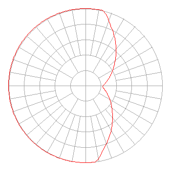 | ||||||||||||||||||
| Azimuth | Ratio | Azimuth | Ratio | Azimuth | Ratio | Azimuth | Ratio | ||||||||||||
| 3 | 1.000 | 13 | 1.000 | 23 | 0.841 | 33 | 0.707 | ||||||||||||
| 43 | 0.582 | 53 | 0.473 | 63 | 0.389 | 73 | 0.316 | ||||||||||||
| 83 | 0.260 | 93 | 0.223 | 103 | 0.260 | 113 | 0.316 | ||||||||||||
| 123 | 0.389 | 133 | 0.473 | 143 | 0.582 | 153 | 0.707 | ||||||||||||
| 163 | 0.841 | 173 | 1.000 | 183 | 1.000 | 193 | 1.000 | ||||||||||||
| 203 | 1.000 | 213 | 1.000 | 223 | 1.000 | 233 | 1.000 | ||||||||||||
| 243 | 1.000 | 253 | 1.000 | 263 | 1.000 | 273 | 1.000 | ||||||||||||
| 283 | 1.000 | 293 | 1.000 | 303 | 1.000 | 313 | 1.000 | ||||||||||||
| 323 | 1.000 | 333 | 1.000 | 343 | 1.000 | 353 | 1.000 | ||||||||||||
Structure Registration Number 1040403 Structure Type: TOWER Registered To: Pinnacle Towers LLC Structure Address: 3251 Harrison Road Montgomery, AL County Name: Montgomery County ASR Issued: 05/06/2016 Date Built: 07/07/1990 Site Elevation: 86.9 m (285 ft.) Structure Height: 215.2 m (706 ft.) Height Overall: 222.2 m (729 ft.) Overall Height AMSL: 309.1 m (1014 ft.) FAA Determination: 04/23/2012 FAA Study #: 2012-ASO-3164-OE FAA Circular #: 70/7460-1K Paint & Light FAA Chapters: 3, 4, 5, 12 PRIOR STUDY 2011-ASO-3909-OE 32-22-04.1 N 86-15-42.0 W (NAD 83) 32-22-03.6 N 86-15-42.1 W (Converted to NAD 27) Crown Castle 1040403 - Pinnacle Towers LLC |
P. O. Box 369 Greenville, AL 36037 Phone: 334-382-6555 | Date: 02/27/2017 Application Certifier AUTAUGAVILLE RADIO, INC. P.o. Box 369 Greenville, AL 36037 Applicant LEE S. REYNOLDS 5256 Valleybrook Trace Birmingham, AL 35244 TECHNICAL CONSULTANT CARY S. TEPPER, ESQ. Tepper Law Firm, Llc 4900 Auburn Avenue Suite 100 Bethesda, MD 20814-2632 | |||||||||||||||||