
FCCInfo.com
A Service of Cavell, Mertz & Associates, Inc.
(855) FCC-INFO
|
|
|
|
|
||||||||||||||||
|
|
WMVE Channel: 211C3 90.1 MHz Chase City, Virginia Service: FM - A full-service FM station or application. Facility ID: 90273 Fac. Service: FM Analog & Digital Status: License Application Accepted: 10/10/2007 Application Granted: 10/26/2007 File Number: BLED-20071010ACE License Expires: 00/00/0000 Prefix Type: This is a license for a noncommercial educational FM station Application Type: License To Cover FCC Website Links: LMS Facility Details This Application CDBS Application Other WMVE Applications Other WMVE Applications in CDBS Including Superseded Applications Mailing Address Correspondence for WMVE Correspondence related to application BLED-20071010ACE Service Contour - Open Street Map or USGS Map (60 dBu) Service Contour - KML / Google Earth (60 dBu) Public Inspection Files Facility Type: NON-COMMERCIAL EDUC. FM Class: C3, A Zone II station; with 6kW-25kW ERP and a class contour distance 28km-39km Site Location: 36-46-29.5 N 78-20-40.0 W (NAD 83) Site Location: 36-46-29.0 N 78-20-41.0 W (Converted to NAD 27) Effective Radiated Power: 8 kW Transmitter Output Power: 6 kW Antenna Center HAAT: 113 m (371 ft.) Antenna Center AMSL: 232 m (761 ft.) Antenna Center HAG: 84 m (276 ft.) Site Elevation: 148 m. (486 ft.) Height Overall*: 91.1 m (299 ft.) (* As Filed In This Application, may differ from ASR Data, Below.) Directional Antenna Antenna Make/Model: DIELECTRIC DCRH2ERD, two sections Antenna ID: 15519 Polarization: | ||||||||||||||||||
| Antenna Data for Antenna Id: 15519 WMVE FM File: BLED-20071010ACE DIELECTRIC - DCRH2ERD, two sections Service: FM | 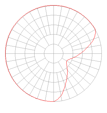 | ||||||||||||||||||
| Azimuth | Ratio | Azimuth | Ratio | Azimuth | Ratio | Azimuth | Ratio | ||||||||||||
| 0 | 1.000 | 10 | 1.000 | 20 | 1.000 | 30 | 1.000 | ||||||||||||
| 40 | 1.000 | 50 | 1.000 | 60 | 1.000 | 70 | 0.891 | ||||||||||||
| 80 | 0.708 | 90 | 0.563 | 100 | 0.447 | 110 | 0.355 | ||||||||||||
| 120 | 0.316 | 130 | 0.355 | 140 | 0.447 | 150 | 0.563 | ||||||||||||
| 160 | 0.708 | 170 | 0.891 | 180 | 1.000 | 190 | 1.000 | ||||||||||||
| 200 | 1.000 | 210 | 1.000 | 220 | 1.000 | 230 | 1.000 | ||||||||||||
| 240 | 1.000 | 250 | 1.000 | 260 | 1.000 | 270 | 1.000 | ||||||||||||
| 280 | 1.000 | 290 | 1.000 | 300 | 1.000 | 310 | 1.000 | ||||||||||||
| 320 | 1.000 | 330 | 1.000 | 340 | 1.000 | 350 | 1.000 | ||||||||||||
Structure Registration Number 1018223 Structure Type: TOWER Registered To: CENTRAL VIRGINIA EDUCATIONAL TELECOMMUNICATIONS CORP Structure Address: On Left Side Rt 660 1 Mi S Of Rt 47 Chase City, VA County Name: Mecklenburg County ASR Issued: 08/18/1997 Date Built: 01/01/1967 Site Elevation: 148.1 m (486 ft.) Structure Height: 84.5 m (277 ft.) Height Overall: 91.1 m (299 ft.) Overall Height AMSL: 239.2 m (785 ft.) FAA Determination: 06/11/1997 FAA Study #: 97-AEA-0900-OE FAA Circular #: 70/7460-1J Paint & Light FAA Chapters: 3, 4, 5, 13 36-46-30.0 N 78-20-40.0 W (NAD 83) 36-46-29.5 N 78-20-41.0 W (Converted to NAD 27) |
23 Sesame Street Richmond, VA 23235 Phone: 804-320-1301 | Date: 10/10/2007 Application Certifier COMMONWEALTH PUBLIC BROADCASTION 23 Sesame St Richmond, VA 23235 Applicant SAM STRAUS CPBE 23 Sesame St Richmond, VA 23235 TECHNICAL DIRECTOR SAM STRAUS Commonwealth Public Broadcast | |||||||||||||||||