
FCCInfo.com
A Service of Cavell, Mertz & Associates, Inc.
(855) FCC-INFO
|
|
|
|  |
|
|||||||||||||||
|
|
WGDE Channel: 220A 91.9 MHz Defiance, Ohio Service: FM - A full-service FM station or application. Facility ID: 53713 Fac. Service: FM Status: License Application Accepted: 03/05/1999 Application Granted: 11/02/1999 File Number: BLED-19990305KB License Expires: 00/00/0000 Prefix Type: This is a license for a noncommercial educational FM station Application Type: License To Cover FCC Website Links: LMS Facility Details This Application CDBS Application Other WGDE Applications Other WGDE Applications in CDBS Including Superseded Applications Mailing Address Correspondence for WGDE Correspondence related to application BLED-19990305KB Service Contour - Open Street Map or USGS Map (60 dBu) Service Contour - KML / Google Earth (60 dBu) Public Inspection Files Facility Type: NON-COMMERCIAL EDUC. FM Class: A, A Zone I; I-A; or II station; with 0.1kW-6kW ERP and a class contour distance <=28km Site Location: 41-17-41.2 N 84-23-23.8 W (NAD 83) Site Location: 41-17-41.0 N 84-23-24.0 W (Converted to NAD 27) Effective Radiated Power: 6 kW Transmitter Output Power: 1.95 kW Antenna Center HAAT: 93 m (305 ft.) Antenna Center AMSL: 308 m (1010 ft.) Antenna Center HAG: 95 m (312 ft.) Site Elevation: 213 m. (699 ft.) Height Overall*: 100 m (328 ft.) (* As Filed In This Application, may differ from ASR Data, Below.) Directional Antenna Antenna Make/Model: DIELECTRIC DCRH3ED Antenna ID: 14748 Polarization: | ||||||||||||||||||
| Antenna Data for Antenna Id: 14748 WGDE FM File: BLED-19990305KB DIELECTRIC - DCRH3ED Service: FM | 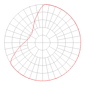 | ||||||||||||||||||
| Azimuth | Ratio | Azimuth | Ratio | Azimuth | Ratio | Azimuth | Ratio | ||||||||||||
| 0 | 0.944 | 5 | 1.000 | 10 | 1.000 | 20 | 1.000 | ||||||||||||
| 30 | 1.000 | 40 | 1.000 | 50 | 1.000 | 60 | 1.000 | ||||||||||||
| 70 | 1.000 | 80 | 1.000 | 90 | 1.000 | 100 | 1.000 | ||||||||||||
| 110 | 1.000 | 120 | 1.000 | 130 | 1.000 | 140 | 1.000 | ||||||||||||
| 150 | 1.000 | 160 | 1.000 | 170 | 1.000 | 180 | 1.000 | ||||||||||||
| 190 | 1.000 | 200 | 1.000 | 210 | 1.000 | 220 | 1.000 | ||||||||||||
| 230 | 1.000 | 235 | 1.000 | 240 | 0.944 | 250 | 0.750 | ||||||||||||
| 260 | 0.596 | 270 | 0.473 | 280 | 0.408 | 290 | 0.364 | ||||||||||||
| 300 | 0.366 | 310 | 0.364 | 320 | 0.408 | 330 | 0.473 | ||||||||||||
| 340 | 0.596 | 350 | 0.750 | ||||||||||||||||
Structure Registration Number 1057781 Structure Type: TOWER Registered To: PUBLIC BROADCASTING FOUNDATION OF NORTHWEST OHIO Structure Address: Off Hwy 15, 7/10 Mile South Of Brunersburg Brunersburg, OH County Name: Defiance County ASR Issued: 11/05/1998 Date Built: 01/20/1999 Site Elevation: 213 m (699 ft.) Structure Height: 99 m (325 ft.) Height Overall: 100 m (328 ft.) Overall Height AMSL: 313 m (1027 ft.) FAA Determination: 05/30/1995 FAA Study #: 95-AGL-1321-OE FAA Circular #: 70/7460-1H Paint & Light FAA Chapters: 3, 4, 5, 13 41-17-41.0 N 84-23-24.0 W (NAD 83) 41-17-40.8 N 84-23-24.2 W (Converted to NAD 27) |
1270 South Detroit Avenue Box 30 Toledo, OH 43614 Phone: 419-380-4600 | Date: 03/05/1999 Application Certifier PUB. BR/CAST. FOUNDATION OF NW OHIO Public Broadcasting Foundation Of Northwest Ohio 136 N. Huron St. Toledo, OH 43697 Applicant | |||||||||||||||||