
FCCInfo.com
A Service of Cavell, Mertz & Associates, Inc.
(855) FCC-INFO
|
|
|
|
|
||||||||||||||||
|
|
K269GF Channel: 269D 101.7 MHz El Paso, Texas Service: FX - A translator or application for a translator. Facility ID: 156979 Fac. Service: FX Programming Delivery Method: Unspecified Status: License Application Accepted: 03/16/2018 Application Granted: 04/03/2018 File Number: BLFT-20180316ABL License Expires: 00/00/0000 Prefix Type: This is a license for a translator Application Type: License To Cover FCC Website Links: LMS Facility Details This Application CDBS Application Other K269GF Applications Other K269GF Applications in CDBS Including Superseded Applications Mailing Address Correspondence for K269GF Correspondence related to application BLFT-20180316ABL Service Contour - Open Street Map or USGS Map (60 dBu) Service Contour - KML / Google Earth (60 dBu) Class: D, A Noncommercial educational operating with no more than 10W Site Location: 31-48-57.4 N 106-29-20.0 W (NAD 83) Site Location: 31-48-57.0 N 106-29-18.0 W (Converted to NAD 27) Effective Radiated Power: 0.01 kW Transmitter Output Power: 0.015 kW Antenna Center HAAT: 0 m Antenna Center AMSL: 1764 m (5787 ft.) Antenna Center HAG: 21 m (69 ft.) Site Elevation: 1743 m. (5719 ft.) Height Overall*: 131 m (430 ft.) (* As Filed In This Application, may differ from ASR Data, Below.) Directional Antenna Antenna Make/Model: None Antenna ID: 16149 Polarization:
| ||||||||||||||||||
| Antenna Data for Antenna Id: 16149 K269GF FX File: BLFT-20180316ABL None - Service: FX Pattern and Field Values Include a 87° Clockwise Rotation | 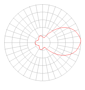 | ||||||||||||||||||
| Azimuth | Ratio | Azimuth | Ratio | Azimuth | Ratio | Azimuth | Ratio | ||||||||||||
| 7 | 0.142 | 17 | 0.134 | 27 | 0.190 | 37 | 0.329 | ||||||||||||
| 47 | 0.528 | 57 | 0.718 | 67 | 0.866 | 77 | 0.952 | ||||||||||||
| 87 | 1.000 | 97 | 0.952 | 107 | 0.866 | 117 | 0.718 | ||||||||||||
| 127 | 0.528 | 137 | 0.329 | 147 | 0.190 | 157 | 0.134 | ||||||||||||
| 167 | 0.142 | 177 | 0.157 | 187 | 0.181 | 197 | 0.187 | ||||||||||||
| 207 | 0.171 | 217 | 0.140 | 227 | 0.123 | 237 | 0.135 | ||||||||||||
| 247 | 0.160 | 257 | 0.182 | 267 | 0.193 | 277 | 0.182 | ||||||||||||
| 287 | 0.160 | 297 | 0.135 | 307 | 0.123 | 317 | 0.140 | ||||||||||||
| 327 | 0.171 | 337 | 0.187 | 347 | 0.181 | 357 | 0.157 | ||||||||||||
Structure Registration Number 1216164 Structure Type: TOWER Registered To: KSCE TV-38 Christian Television Structure Address: Franklin Mountain El Paso, TX County Name: El Paso County ASR Issued: 08/17/2000 Site Elevation: 1743 m (5719 ft.) Structure Height: 131 m (430 ft.) Height Overall: 131 m (430 ft.) Overall Height AMSL: 1874 m (6148 ft.) FAA Determination: 07/22/1999 FAA Study #: 99-ASW-2228-OE FAA Circular #: 70/7460-1J Paint & Light FAA Chapters: 3, 4, 5, 13 31-48-57.0 N 106-29-20.2 W (NAD 83) 31-48-56.6 N 106-29-18.2 W (Converted to NAD 27) |
P.o. Box 1118 Santa Rosa, CA 95402 Phone: 707-479-9428 Not-for-Profit | Date: 03/16/2018 Application Certifier ONE MINISTRIES, INC. P.o. Box 1118 Santa Rosa, CA 95402-1118 Applicant KEITH LEITCH P.o Box 1118 Santa Rosa, CA 95402-1118 ENGINEER JAMES L. OYSTER Law Offices Of James L. Oyster 108 Oyster Lane Castleton, VA 22716-2839 | |||||||||||||||||