
FCCInfo.com
A Service of Cavell, Mertz & Associates, Inc.
(855) FCC-INFO
|
|
|
|
|
||||||||||||||||
|
|
WSIZ-FM Channel: 272A 102.3 MHz Jacksonville, Georgia Service: FM - A full-service FM station or application. Facility ID: 165953 Fac. Service: FM Status: License 73.215 Station Application Accepted: 08/09/2010 Application Granted: 08/13/2010 File Number: BLH-20100809CNL License Expires: 00/00/0000 Prefix Type: This is a license for a commercial FM station Application Type: License To Cover FCC Website Links: LMS Facility Details This Application CDBS Application Other WSIZ-FM Applications Other WSIZ-FM Applications in CDBS Including Superseded Applications Mailing Address Correspondence for WSIZ-FM Correspondence related to application BLH-20100809CNL Service Contour - Open Street Map or USGS Map (60 dBu) Service Contour - KML / Google Earth (60 dBu) Public Inspection Files Facility Type: FM STATION Class: A, A Zone I; I-A; or II station; with 0.1kW-6kW ERP and a class contour distance <=28km Site Location: 31-46-42.7 N 83-05-06.5 W (NAD 83) Site Location: 31-46-42.0 N 83-05-07.0 W (Converted to NAD 27) Effective Radiated Power: 5.5 kW Transmitter Output Power: 2.63 kW Antenna Center HAAT: 102 m (335 ft.) Antenna Center AMSL: 170 m (558 ft.) Antenna Center HAG: 94 m (308 ft.) Calculated Site Elevation: 76 m. (249 ft.) Height Overall*: 98 m (322 ft.) (* As Filed In This Application, may differ from ASR Data, Below.) Directional Antenna Antenna Make/Model: Propagation System Inc PSIFM-4-DA, 4 section Antenna ID: 85111 Polarization: | ||||||||||||||||||
| Antenna Data for Antenna Id: 85111 WSIZ-FM FM File: BLH-20100809CNL Propagation System Inc - PSIFM-4-DA, 4 section Service: FM | 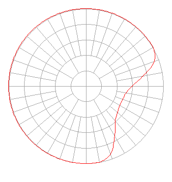 | ||||||||||||||||||
| Azimuth | Ratio | Azimuth | Ratio | Azimuth | Ratio | Azimuth | Ratio | ||||||||||||
| 0 | 1.000 | 10 | 1.000 | 20 | 1.000 | 30 | 1.000 | ||||||||||||
| 40 | 1.000 | 50 | 1.000 | 60 | 1.000 | 70 | 0.940 | ||||||||||||
| 80 | 0.749 | 90 | 0.597 | 100 | 0.523 | 110 | 0.505 | ||||||||||||
| 120 | 0.503 | 130 | 0.532 | 140 | 0.590 | 150 | 0.741 | ||||||||||||
| 160 | 0.930 | 170 | 1.000 | 180 | 1.000 | 190 | 1.000 | ||||||||||||
| 200 | 1.000 | 210 | 1.000 | 220 | 1.000 | 230 | 1.000 | ||||||||||||
| 240 | 1.000 | 250 | 1.000 | 260 | 1.000 | 270 | 1.000 | ||||||||||||
| 280 | 1.000 | 290 | 1.000 | 300 | 1.000 | 310 | 1.000 | ||||||||||||
| 320 | 1.000 | 330 | 1.000 | 340 | 1.000 | 350 | 1.000 | ||||||||||||
Structure Registration Number 1255270 [ASR Heights Differ from WSIZ-FM Application] Structure Type: Registered To: Middle Georgia Community Radio Structure Address: 8.95 Acres, Ll 115, 4th Dist., Ben Hill County, Ga Fitzgerald, GA County Name: Ben Hill County ASR Issued: 01/06/2022 Date Built: 08/09/2010 Site Elevation: 76.2 m (250 ft.) Structure Height: 97.5 m (320 ft.) Height Overall: 97.5 m (320 ft.) Overall Height AMSL: 173.7 m (570 ft.) FAA Determination: 09/12/2006 FAA Study #: 2006-aso-4313-oe FAA Circular #: 70/7460-1K Paint & Light FAA Chapters: 3, 4, 5, 12 Removed expiration date from determination. Scenario 1./jjs/case#635066 31-46-42.7 N 83-05-06.3 W (NAD 83) 31-46-42.0 N 83-05-06.8 W (Converted to NAD 27) |
P.o. Box 158 Fitzgerald, GA 31750 Phone: 806-340-1284 Corporation | Date: 08/09/2010 Application Certifier WORLD RADIO LINK, INC. Po Box 5429 Twin Falls, ID 83303-5429 Applicant GENE WISNIEWSKI P. O. Box 5429 Twin Falls, ID 83303 CONSULTING ENGINEER CLARK PARRISH World Radio Link Incorporated | |||||||||||||||||
| |||||||||||||||||||