
FCCInfo.com
A Service of Cavell, Mertz & Associates, Inc.
(855) FCC-INFO
|
|
|
|  |
|
|||||||||||||||
|
|
WWSP Channel: 210C2 89.9 MHz Stevens Point, Wisconsin Service: FM - A full-service FM station or application. Facility ID: 4286 Fac. Service: FM Status: License Application Accepted: 06/11/2008 Application Granted: 06/23/2008 File Number: BLED-20080611ABK License Expires: 00/00/0000 Prefix Type: This is a license for a noncommercial educational FM station Application Type: License To Cover FCC Website Links: LMS Facility Details This Application CDBS Application Other WWSP Applications Other WWSP Applications in CDBS Including Superseded Applications Mailing Address Correspondence for WWSP Correspondence related to application BLED-20080611ABK Service Contour - Open Street Map or USGS Map (60 dBu) Service Contour - KML / Google Earth (60 dBu) Public Inspection Files History Cards for WWSP Facility Type: NON-COMMERCIAL EDUC. FM Class: C2, A Zone II station; with 25kW-50kW ERP and a class contour distance 39km-52km Site Location: 44-28-54.9 N 89-40-35.4 W (NAD 83) Site Location: 44-28-55.0 N 89-40-35.0 W (Converted to NAD 27) Effective Radiated Power: 30 kW Transmitter Output Power: 6.18 kW Antenna Center HAAT: 97.9 m (321 ft.) Antenna Center AMSL: 425.2 m (1395 ft.) Antenna Center HAG: 69.2 m (227 ft.) Site Elevation: 356 m. (1168 ft.) Height Overall*: 78.6 m (258 ft.) (* As Filed In This Application, may differ from ASR Data, Below.) Directional Antenna Antenna Make/Model: DIELECTRIC DCR-H5ER, five sections Antenna ID: 70927 Polarization: | ||||||||||||||||||
| Antenna Data for Antenna Id: 70927 WWSP FM File: BLED-20080611ABK DIELECTRIC - DCR-H5ER, five sections Service: FM | 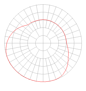 | ||||||||||||||||||
| Azimuth | Ratio | Azimuth | Ratio | Azimuth | Ratio | Azimuth | Ratio | ||||||||||||
| 0 | 0.604 | 10 | 0.603 | 20 | 0.602 | 30 | 0.599 | ||||||||||||
| 40 | 0.599 | 50 | 0.599 | 60 | 0.600 | 70 | 0.601 | ||||||||||||
| 80 | 0.602 | 90 | 0.611 | 100 | 0.647 | 110 | 0.699 | ||||||||||||
| 120 | 0.753 | 130 | 0.835 | 140 | 0.913 | 150 | 0.970 | ||||||||||||
| 160 | 0.995 | 170 | 1.000 | 180 | 1.000 | 190 | 1.000 | ||||||||||||
| 200 | 1.000 | 210 | 1.000 | 220 | 1.000 | 230 | 1.000 | ||||||||||||
| 240 | 1.000 | 250 | 0.995 | 260 | 0.970 | 270 | 0.934 | ||||||||||||
| 280 | 0.882 | 290 | 0.824 | 300 | 0.751 | 310 | 0.676 | ||||||||||||
| 320 | 0.615 | 330 | 0.609 | 340 | 0.601 | 350 | 0.602 | ||||||||||||
Structure Registration Number 1058107 Structure Type: TOWER Registered To: BOARD OF REGENTS OF THE UNIVERSITY OF WISCONSIN SYSTEM DBA = WWSP FM Structure Address: 2401 County Pp Stevens Point, WI County Name: Portage County ASR Issued: 11/17/1998 Date Built: 06/01/1990 Site Elevation: 356 m (1168 ft.) Structure Height: 78.6 m (258 ft.) Height Overall: 78.6 m (258 ft.) Overall Height AMSL: 434.6 m (1426 ft.) FAA Determination: 10/06/1998 FAA Study #: 98-AGL-4739-OE FAA Circular #: 70/7460-1G Paint & Light FAA Chapters: 3, 4, 5, 9 PRIOR FAA 98-AGL-2609-OE 44-28-55.0 N 89-40-35.0 W (NAD 83) 44-28-55.1 N 89-40-34.6 W (Converted to NAD 27) |
1220 Linden Drive Madison, WI 53706 Phone: 608-262-2324 Government Entity | Date: 06/11/2008 Application Certifier BOARD OF REGENTS OF THE UNIVERSITY OF WISCONSIN SYSTEM 1730 Van Hise Hall 1220 Linden Dr. Madison, WI 53706 Applicant B. BENJAMIN EVANS, P.E. 210 S. Main Street Thiensville, WI 53092-1905 CONSULTING ENGINEER BARRY S. PERSH Dow Lohnes Pllc | |||||||||||||||||
|
| ||||||||||||||||||