
FCCInfo.com
A Service of Cavell, Mertz & Associates, Inc.
(855) FCC-INFO
|
|
|
|
|
||||||||||||||||
|
|
K271BX Channel: 271D 102.1 MHz Stockton, California Service: FX - A translator or application for a translator. Facility ID: 140748 Fac. Service: FX Programming Delivery Method: Unspecified Status: License Application Accepted: 04/29/2016 Application Granted: 05/16/2016 File Number: BLFT-20160429AAI License Expires: 00/00/0000 Prefix Type: This is a license for a translator Application Type: License To Cover FCC Website Links: LMS Facility Details This Application CDBS Application Other K271BX Applications Other K271BX Applications in CDBS Including Superseded Applications Mailing Address Correspondence for K271BX Correspondence related to application BLFT-20160429AAI Service Contour - Open Street Map or USGS Map (60 dBu) Service Contour - KML / Google Earth (60 dBu) Class: D, A Noncommercial educational operating with no more than 10W Site Location: 37-57-29.8 N 121-16-58.6 W (NAD 83) Site Location: 37-57-30.1 N 121-16-54.8 W (Converted to NAD 27) Effective Radiated Power: 0 kW Horiz. ; 0.019 kW Vert. Transmitter Output Power: 0.026 kW Antenna Center HAAT: 0 m Antenna Center AMSL: 0 m Horiz.; 101 m Vert. Antenna Center HAG: 0 m Horiz.; 96 m Vert. Site Elevation: 5 m. (16 ft.) Height Overall*: 123 m (404 ft.) (* As Filed In This Application, may differ from ASR Data, Below.) Directional Antenna Antenna Make/Model: None Antenna ID: 124438 Polarization:
| ||||||||||||||||||
| Antenna Data for Antenna Id: 124438 K271BX FX File: BLFT-20160429AAI None - Service: FX | 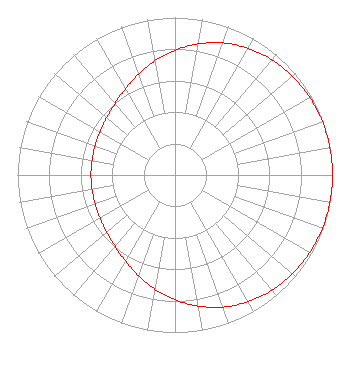 | ||||||||||||||||||
| Azimuth | Ratio | Azimuth | Ratio | Azimuth | Ratio | Azimuth | Ratio | ||||||||||||
| 0 | 0.792 | 10 | 0.845 | 20 | 0.892 | 30 | 0.929 | ||||||||||||
| 40 | 0.956 | 50 | 0.975 | 60 | 0.987 | 70 | 0.995 | ||||||||||||
| 80 | 0.999 | 90 | 1.000 | 100 | 0.999 | 110 | 0.995 | ||||||||||||
| 120 | 0.987 | 130 | 0.975 | 140 | 0.956 | 150 | 0.929 | ||||||||||||
| 160 | 0.892 | 170 | 0.845 | 180 | 0.792 | 190 | 0.735 | ||||||||||||
| 200 | 0.679 | 210 | 0.630 | 220 | 0.592 | 230 | 0.566 | ||||||||||||
| 240 | 0.549 | 250 | 0.540 | 260 | 0.535 | 270 | 0.534 | ||||||||||||
| 280 | 0.535 | 290 | 0.540 | 300 | 0.549 | 310 | 0.566 | ||||||||||||
| 320 | 0.592 | 330 | 0.630 | 340 | 0.679 | 350 | 0.735 | ||||||||||||
Structure Registration Number 1064433 [ASR Heights Differ from K271BX Application] Structure Type: TOWER Registered To: Bank of Stockton Trustee of the Ann Matlow Trust Structure Address: 721 E. Lindsay Street Stockton, CA County Name: San Joaquin County ASR Issued: 01/15/2018 Date Built: 04/12/1999 Site Elevation: 4.5 m (15 ft.) Structure Height: 121.9 m (400 ft.) Height Overall: 122.5 m (402 ft.) Overall Height AMSL: 127 m (417 ft.) FAA Determination: 03/13/2006 FAA Study #: 2006-AWP-880-OE FAA Circular #: 70/7460-1K Paint & Light FAA Chapters: 3, 4, 5, 12 PRIOR STUDY 1998-AWP-2582-OE 37-57-29.8 N 121-16-58.6 W (NAD 83) 37-57-30.1 N 121-16-54.8 W (Converted to NAD 27) |
4043 Geer Rd. Hughson, CA 95326 Phone: 209-883-8760 Corporation | Date: 04/29/2016 Application Certifier MARY V. GUTHRIE 2310 Ponderosa Dr. #28 Camarillo, CA 93010 Applicant CARL GLUCK Carl T. Jones Corp 7901 Yarnwood Court Springfield, VA 22153-2899 TECHNICAL CONSULTANT JOHN NEELY, ESQ Miller And Neely Pc Suite 203 3750 University Blvd., West Kensington, MD 20895 | |||||||||||||||||