
FCCInfo.com
A Service of Cavell, Mertz & Associates, Inc.
(855) FCC-INFO
|
|
W274BT from 06/12/2015 W274BT from 05/02/2014 |
|
|
||||||||||||||||
|
|
W274BT Channel: 274D 102.7 MHz Williston, Florida Service: FX - A translator or application for a translator. Facility ID: 149342 Fac. Service: FX Programming Delivery Method: Unspecified Status: License Application Accepted: 10/28/2015 Application Granted: 07/11/2016 File Number: BLFT-20151028AAB License Expires: 00/00/0000 Prefix Type: This is a license for a translator Application Type: License To Cover FCC Website Links: LMS Facility Details This Application CDBS Application Other W274BT Applications Other W274BT Applications in CDBS Including Superseded Applications Mailing Address Correspondence for W274BT Correspondence related to application BLFT-20151028AAB Service Contour - Open Street Map or USGS Map (60 dBu) Service Contour - KML / Google Earth (60 dBu) Class: D, A Noncommercial educational operating with no more than 10W Site Location: 29-42-34.9 N 82-23-39.4 W (NAD 83) Site Location: 29-42-34.0 N 82-23-40.0 W (Converted to NAD 27) Effective Radiated Power: 0.205 kW Transmitter Output Power: 0.356 kW Antenna Center HAAT: 0 m Antenna Center AMSL: 185 m (607 ft.) Antenna Center HAG: 130 m (427 ft.) Site Elevation: 55 m. (180 ft.) Height Overall*: 257 m (843 ft.) (* As Filed In This Application, may differ from ASR Data, Below.) Directional Antenna Antenna Make/Model: None Antenna ID: 122053 Polarization:
| ||||||||||||||||||
| Antenna Data for Antenna Id: 122053 W274BT FX File: BLFT-20151028AAB None - Service: FX Pattern and Field Values Include a 58° Clockwise Rotation | 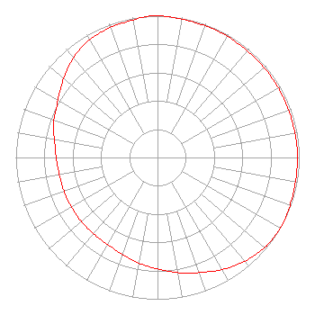 | ||||||||||||||||||
| Azimuth | Ratio | Azimuth | Ratio | Azimuth | Ratio | Azimuth | Ratio | ||||||||||||
| 8 | 0.992 | 18 | 0.988 | 28 | 0.988 | 38 | 0.983 | ||||||||||||
| 48 | 0.983 | 58 | 0.983 | 68 | 0.983 | 78 | 0.983 | ||||||||||||
| 88 | 0.988 | 98 | 0.988 | 108 | 0.992 | 118 | 1.000 | ||||||||||||
| 128 | 0.991 | 138 | 0.963 | 148 | 0.923 | 158 | 0.873 | ||||||||||||
| 168 | 0.832 | 178 | 0.792 | 188 | 0.762 | 198 | 0.732 | ||||||||||||
| 208 | 0.710 | 218 | 0.702 | 228 | 0.702 | 238 | 0.702 | ||||||||||||
| 248 | 0.702 | 258 | 0.702 | 268 | 0.712 | 278 | 0.732 | ||||||||||||
| 288 | 0.772 | 298 | 0.802 | 308 | 0.853 | 318 | 0.909 | ||||||||||||
| 328 | 0.953 | 338 | 0.973 | 348 | 0.983 | 358 | 1.000 | ||||||||||||
Structure Registration Number 1029807 Structure Type: TOWER Registered To: Board of Trustees, University of Florida Structure Address: 4732 Nw 53rd Ave Gainesville, FL County Name: Alachua County ASR Issued: 01/20/2021 Date Built: 04/28/2005 Site Elevation: 54.9 m (180 ft.) Structure Height: 238.4 m (782 ft.) Height Overall: 257.2 m (844 ft.) Overall Height AMSL: 312.1 m (1024 ft.) FAA Determination: 02/25/2004 FAA Study #: 2004-ASO-664-OE FAA Circular #: 70/7460-1F Paint & Light FAA Chapters: 4, 6, 9 PRIOR FAA 80-ASO-2042-OE. OM&L TO REMAIN THE SAME AS PRIOR STUDY = 24-HR HI-STROBES 29-42-34.9 N 82-23-39.4 W (NAD 83) 29-42-34.0 N 82-23-40.0 W (Converted to NAD 27) |
P.o. Box 118405 2202a Weimer Hall Gainesville, DC 32604-8405 Phone: 202-298-2534 | Date: 10/28/2015 Application Certifier EDGEWATER BROADCASTING, INC. 160 Gooding St. W. Suite B Twin Falls, ID 83301 Applicant GENE WISNIEWSKI 160 Gooding Street West Suite A Twin Falls, ID 83301 CONSULTING ENGINEER CLARK PARRISH Edgewater Broadcasting, Inc. 160 Gooding St. W. Suite B Twin Falls, ID 83301 | |||||||||||||||||