
FCCInfo.com
A Service of Cavell, Mertz & Associates, Inc.
(855) FCC-INFO
|
|
KBRQ from 09/14/1983 |
|
|
||||||||||||||||
|
|
KBRQ Channel: 273C1 102.5 MHz Hillsboro, Texas Service: FM - A full-service FM station or application. Facility ID: 60805 Fac. Service: FM Status: License 73.215 Station Application Accepted: 10/18/2016 Application Granted: 11/14/2016 File Number: BMLH-20161018AAT License Expires: 00/00/0000 Prefix Type: This is a modification of a license for a commecial FM station Application Type: Minor Modification FCC Website Links: LMS Facility Details This Application CDBS Application Other KBRQ Applications Other KBRQ Applications in CDBS Including Superseded Applications Mailing Address Correspondence for KBRQ Correspondence related to application BMLH-20161018AAT Service Contour - Open Street Map or USGS Map (60 dBu) Service Contour - KML / Google Earth (60 dBu) Public Inspection Files History Cards for KBRQ Facility Type: FM STATION Class: C1, A Zone II station; with 50kW-100kW ERP and a class contour distance 52km-72km Site Location: 31-49-29.9 N 97-09-33.2 W (NAD 83) Site Location: 31-49-29.3 N 97-09-32.2 W (Converted to NAD 27) Effective Radiated Power: 100 kW Transmitter Output Power: 11.3 kW Antenna Center HAAT: 137 m (449 ft.) Antenna Center AMSL: 305 m (1001 ft.) Antenna Center HAG: 136 m (446 ft.) Calculated Site Elevation: 169 m. (554 ft.) Height Overall*: 151 m (495 ft.) (* As Filed In This Application, may differ from ASR Data, Below.) Directional Antenna Antenna Make/Model: DIELECTRIC DCRC10CHD Antenna ID: 108876 Polarization: | ||||||||||||||||||
| Antenna Data for Antenna Id: 108876 KBRQ FM File: BMLH-20161018AAT DIELECTRIC - DCRC10CHD Service: FM | 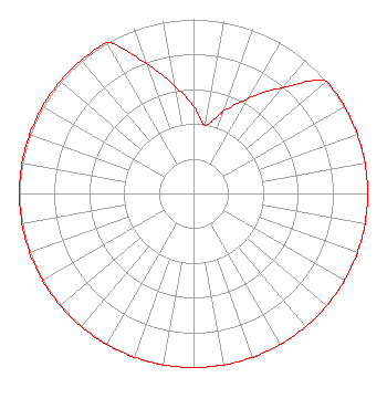 | ||||||||||||||||||
| Azimuth | Ratio | Azimuth | Ratio | Azimuth | Ratio | Azimuth | Ratio | ||||||||||||
| 0 | 0.501 | 10 | 0.398 | 20 | 0.501 | 30 | 0.631 | ||||||||||||
| 40 | 0.794 | 50 | 1.000 | 60 | 1.000 | 70 | 1.000 | ||||||||||||
| 80 | 1.000 | 90 | 1.000 | 100 | 1.000 | 110 | 1.000 | ||||||||||||
| 120 | 1.000 | 130 | 1.000 | 140 | 1.000 | 150 | 1.000 | ||||||||||||
| 160 | 1.000 | 170 | 1.000 | 180 | 1.000 | 190 | 1.000 | ||||||||||||
| 200 | 1.000 | 210 | 1.000 | 220 | 1.000 | 230 | 1.000 | ||||||||||||
| 240 | 1.000 | 250 | 1.000 | 260 | 1.000 | 270 | 1.000 | ||||||||||||
| 280 | 1.000 | 290 | 1.000 | 300 | 1.000 | 310 | 1.000 | ||||||||||||
| 320 | 1.000 | 330 | 1.000 | 340 | 0.794 | 350 | 0.631 | ||||||||||||
Structure Registration Number 1052363 [ASR Heights Differ from KBRQ Application] Structure Type: GTOWER Registered To: Vertical Bridge CC FM, LLC Structure Address: 173 Hcr 2231 / Us-tx-5055 West, TX County Name: Hill County ASR Issued: 03/19/2019 Date Built: 03/29/2012 Site Elevation: 171.6 m (563 ft.) Structure Height: 148 m (486 ft.) Height Overall: 150.6 m (494 ft.) Overall Height AMSL: 322.2 m (1057 ft.) FAA Determination: 06/11/2018 FAA Study #: 2018-ASW-8615-OE FAA Circular #: 70/7460-1L Paint & Light FAA Chapters: 4, 8, 12 PRIOR STUDY 2015-ASW-4801-OE 31-49-29.9 N 97-09-33.2 W (NAD 83) 31-49-29.3 N 97-09-32.2 W (Converted to NAD 27) |
7136 S. Yale Avenue Tulsa, OK 74136 Phone: 918-664-4581 | Date: 10/18/2016 Application Certifier CLEAR CHANNEL BROADCASTING LICENSES, INC. 2625 S. Memorial Drive Suite A Tulsa, OK 74129-2623 Applicant TROY G. LANGHAM 2625 S. Memorial Dr. Suite A Tulsa, OK 74129 FCC ENGINEERING SUPERVISOR TROY LANGHAM Iheartmedia, Inc. | |||||||||||||||||
|
| ||||||||||||||||||